2022-02-01 51 -1
| Tue 1 Feb 2022 in 51,-1: 51.7805608, -1.4129697 geohashing.info google osm bing/os kml crox |
Location
Near Eynsham, Oxfordshire.
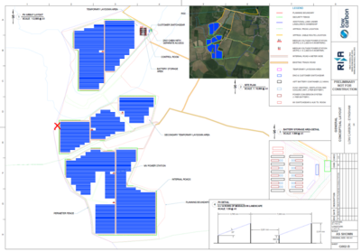
Hashpoint looks like it's close to the banks of Chill Brook, in the grounds of Twelve Acre Farm. There's been a lot of changes to the land around here recently owing to the ongoing construction of a new solar power plant on this land.
Based on planning documents I saw when visiting a presentation about the proposed construction at South Leigh Village Hall last year, I believe the hashpoint is probably outside the new security fence that's proposed. I've marked the anticipated location of the hashpoint on the diagram below:
Participants
Plans
Work-permitting, I plan to cycle out to the trailhead at 51.7774, -1.41957, lock my bike to the "public footpath" sign, cross the footbridge to the East, and trek out to see if the hashpoint itself is accessible. Not sure when I'll find time, though: it's a busy week for both work and home life!
Expedition
Tracklog
Photos
Achievements
