Difference between revisions of "2022-02-19 46 -123"
Michael5000 (talk | contribs) (Created page with "{{subst:Expedition}}") |
Michael5000 (talk | contribs) |
||
| Line 3: | Line 3: | ||
[[Image:{{{image|IMAGE}}}|thumb|left]] | [[Image:{{{image|IMAGE}}}|thumb|left]] | ||
| − | + | {{meetup graticule | |
| − | |||
| − | |||
| − | |||
| − | |||
| lat={{#explode:{{SUBPAGENAME}}| |1}} | | lat={{#explode:{{SUBPAGENAME}}| |1}} | ||
| lon={{#explode:{{SUBPAGENAME}}| |2}} | | lon={{#explode:{{SUBPAGENAME}}| |2}} | ||
| Line 14: | Line 10: | ||
__NOTOC__ | __NOTOC__ | ||
== Location == | == Location == | ||
| − | + | ||
| + | On the beach west of Astoria, Oregon. | ||
== Participants == | == Participants == | ||
| − | |||
| − | |||
| − | + | *[[User:Michael5000|Michael5000]] | |
| − | |||
== Expedition == | == Expedition == | ||
| − | |||
| − | + | The little road trip that started with [[2022-02-19 46 -122]] continued exactly one degree of longitude west, along the lower Columbia River. | |
| − | + | ||
| + | Although I knew that this hashpoint would be quite close to [[2012-05-14 46 -123|one I fought my way to ten years ago]] -- that, indeed, was part of the charm -- I somehow didn't expect to end up at the exact same challenging access point, and to find that its challenges were still as... challenging, I guess, as they were ten years ago. The issue is that the theoretical route to the beach is blocked by large ponds ponds of brackish water in the low points between dunes. | ||
| + | |||
| + | My intention was to run to the hashpoint, but when I saw the first of the ponds I said to myself "well, I'm certainly not wading through those again!" I backtracked a little to a clear trail I had seen heading straight north into the woods, more or less parallel to the beach. At this point, I was imagining that I could run a short distance north to get around the ponds, find a dry path to the beach, and then head back south to arrive at the hashpoint. | ||
| + | |||
| + | And that's kind of what happened. Except, instead of finding a route to the beach in a couple hundred feet, I ended up running north for about 2 1/2 miles. Also, as I went the trail dipped down several times into shallow ponds, some of which I could skirt around but some of which I had to run through ankle-deep. So much for keeping my feet dry. Boy, was I pleased to get to a paved path that led all the way to the beach! | ||
| + | |||
| + | (I happened to be on that particular path last summer, incidentally, and saw a couple walking two enormous pigs on leashes. But I digress.) | ||
| + | |||
| + | So then I was on the beach, running back south, and it was very unpleasant. I could not find firm sand to run on, so it was laborious, and with a strong headwind, sea spray, and heavy mist I was soon exhausted and sopping wet. More than a mile from the hashpoint I stopped to walk, and was soon less exhausted by still sopping wet and increasingly very, very cold. Passing close to where I was parked, with the hashpoint still a half mile south, I decided to give it up and head directly back to the car. | ||
| + | |||
| + | Having given up and climbed off the beach, I was surprised by how much less fierce and wet the wind was. Feeling a little better, I gave up on giving up, turned back south, and fought my way a half mile through beach grass. I fell three times, which is a lot at my age, but I made it. I made it! | ||
| + | |||
| + | Here's my intended route to the hashpoint in blue, and my actual route in red | ||
| + | |||
| + | [[File:2022-02-19 46 -123 8.jpg|500 px]] | ||
| + | |||
| + | As is often the case, I found a way back from the hashpoint that was much easier than the way I approached it. However, that still left me with those damn ponds between me and my car. There was nothing to do for it but mind the electronics and go wading through the black water, often knee deep and at one point to mid-thigh. | ||
| + | |||
| + | I got through with plenty of discomfort but without loss or damage to my gear. Apparently not everyone was so lucky: | ||
| + | |||
| + | [[File:2022-02-19 46 -123 5.jpg|500 px]] | ||
| + | |||
| + | Presumably, that abandoned vehicle belonged to a geohasher with even poorer judgment than mine! | ||
== Photos == | == Photos == | ||
| − | + | ||
| − | |||
| − | |||
<gallery perrow="5"> | <gallery perrow="5"> | ||
| + | File:2022-02-19 46 -123 1.jpg|There's a lot of water in this part of the world. | ||
| + | File:2022-02-19 46 -123 3.jpg|This bridge is four miles long. In the fog, I couldn't see either end for most of it. | ||
| + | File:2022-02-19 46 -123 2.jpg|Looking north from the hashpoint. | ||
| + | File:2022-02-19 46 -123 7.jpg|Looking south from the hashpoint. | ||
| + | File:2022-02-19 46 -123 4.jpg|Looking east, inland, from the hashpoint. | ||
| + | File:2022-02-19 46 -123 6.jpg|Me, looking a bit haggard at the hashpoint. | ||
</gallery> | </gallery> | ||
== Achievements == | == Achievements == | ||
{{#vardefine:ribbonwidth|800px}} | {{#vardefine:ribbonwidth|800px}} | ||
| − | |||
| − | |||
| − | |||
| − | |||
| − | |||
| − | |||
| − | |||
| − | |||
| − | |||
| − | |||
| − | |||
| − | |||
| − | |||
| − | |||
| − | |||
[[Category:Expeditions]] | [[Category:Expeditions]] | ||
| − | |||
[[Category:Expeditions with photos]] | [[Category:Expeditions with photos]] | ||
| − | |||
| − | |||
| − | |||
| − | |||
| − | |||
[[Category:Coordinates reached]] | [[Category:Coordinates reached]] | ||
| − | + | {{Multihash2 | count = 2 | date = 2022-02-19 | name = [[User:Michael5000|Michael5000]] }} | |
| − | + | {{location|US|OR|CT}} | |
| − | |||
| − | |||
| − | |||
| − | |||
| − | |||
| − | |||
| − | |||
| − | |||
| − | |||
| − | [[ | ||
| − | |||
| − | |||
| − | |||
| − | |||
| − | |||
Revision as of 07:37, 20 February 2022
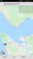
Location
On the beach west of Astoria, Oregon.
Participants
Expedition
The little road trip that started with 2022-02-19 46 -122 continued exactly one degree of longitude west, along the lower Columbia River.
Although I knew that this hashpoint would be quite close to one I fought my way to ten years ago -- that, indeed, was part of the charm -- I somehow didn't expect to end up at the exact same challenging access point, and to find that its challenges were still as... challenging, I guess, as they were ten years ago. The issue is that the theoretical route to the beach is blocked by large ponds ponds of brackish water in the low points between dunes.
My intention was to run to the hashpoint, but when I saw the first of the ponds I said to myself "well, I'm certainly not wading through those again!" I backtracked a little to a clear trail I had seen heading straight north into the woods, more or less parallel to the beach. At this point, I was imagining that I could run a short distance north to get around the ponds, find a dry path to the beach, and then head back south to arrive at the hashpoint.
And that's kind of what happened. Except, instead of finding a route to the beach in a couple hundred feet, I ended up running north for about 2 1/2 miles. Also, as I went the trail dipped down several times into shallow ponds, some of which I could skirt around but some of which I had to run through ankle-deep. So much for keeping my feet dry. Boy, was I pleased to get to a paved path that led all the way to the beach!
(I happened to be on that particular path last summer, incidentally, and saw a couple walking two enormous pigs on leashes. But I digress.)
So then I was on the beach, running back south, and it was very unpleasant. I could not find firm sand to run on, so it was laborious, and with a strong headwind, sea spray, and heavy mist I was soon exhausted and sopping wet. More than a mile from the hashpoint I stopped to walk, and was soon less exhausted by still sopping wet and increasingly very, very cold. Passing close to where I was parked, with the hashpoint still a half mile south, I decided to give it up and head directly back to the car.
Having given up and climbed off the beach, I was surprised by how much less fierce and wet the wind was. Feeling a little better, I gave up on giving up, turned back south, and fought my way a half mile through beach grass. I fell three times, which is a lot at my age, but I made it. I made it!
Here's my intended route to the hashpoint in blue, and my actual route in red

As is often the case, I found a way back from the hashpoint that was much easier than the way I approached it. However, that still left me with those damn ponds between me and my car. There was nothing to do for it but mind the electronics and go wading through the black water, often knee deep and at one point to mid-thigh.
I got through with plenty of discomfort but without loss or damage to my gear. Apparently not everyone was so lucky:

Presumably, that abandoned vehicle belonged to a geohasher with even poorer judgment than mine!
Photos
There's a lot of water in this part of the world.
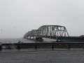
This bridge is four miles long. In the fog, I couldn't see either end for most of it.
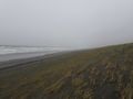
Looking north from the hashpoint.
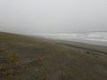
Looking south from the hashpoint.
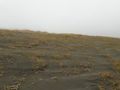
Looking east, inland, from the hashpoint.
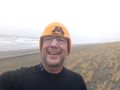
Me, looking a bit haggard at the hashpoint.


Achievements
Michael5000 earned the Multihash Achievement
|