Difference between revisions of "2022-03-11 35 -111"
Felix Dance (talk | contribs) ([retro picture]Meteor Crater instead of hash) |
m (Location) |
||
| (3 intermediate revisions by 2 users not shown) | |||
| Line 1: | Line 1: | ||
| − | + | [[Image:{{{image|2022-03-11_35_-111_Felix Dance_1650350351065.jpg}}}|thumb|left]] | |
| − | + | {{meetup graticule | |
| − | [[Image:{{{image| | ||
| − | |||
| − | |||
| − | |||
| − | |||
| − | |||
| − | |||
| lat=35 | | lat=35 | ||
| lon=-111 | | lon=-111 | ||
| date=2022-03-11 | | date=2022-03-11 | ||
| − | }} | + | }} |
__NOTOC__ | __NOTOC__ | ||
| + | |||
== Location == | == Location == | ||
| − | + | Off a snowy road east of Flagstaff, AZ. | |
== Participants == | == Participants == | ||
| − | + | *[[User:Felix Dance|Felix Dance]] | |
| − | |||
| − | == | + | == Expedition == |
| − | + | A USA fail here. My girlfriend and I had been driving around the SW states of the US in a camper van and this looked like it could have been the first hash accessible with our van. | |
| − | + | I was already driving out that way to check out Meteor Crater - an impact crater in Arizona. My girlfriend was not so interested in that so she stayed in Flagstaff to do some errands. | |
| − | + | ||
| + | It was at this point that I realised that the hash was doable. Sadly, we'd already agreed on our reunion time and I didn't have a SIM card to change the plan (which would have been a bit of a jerk move anyway). I calculated that I could cut short my crater tour by 30 mins to investigate the hash anyway though. | ||
| + | |||
| + | So I drove towards it along the freezing highway. It'd been snowing vigorously overnight so there was a lot of that around. Beautiful scenery though. | ||
| + | |||
| + | I reached the turn-off to the hash, which incredibly luckily happened to have a 4-way freeway on/off-ramp right near it despite the general area being largely bereft of the things. I eased my dinky little camper van towards the dirt road heading to the hash. It was now only 2.5 kms to the hash. The hash itself seemed to be only about 400m from the dirt road. The terrain was free of buildings, houses, trees... anything really except snow and dirt. | ||
| + | |||
| + | BUT... the road looked pretty dodgy. It was very rough, and now also covered in about 5cm of snow. Our two-wheel-drive van would have a hard time on that surface and could easily get bogged. Add to that that the landscape was a bit undulating. I could imagine getting bogged, not being able to reverse or turn around, not having a SIM card to call my girlfriend or anyone else and just... being stuck there. In the absolute middle of nowhere. | ||
| + | |||
| + | After a half-hearted attempt at it, quietly freaking out, I reached a sign that said that the road was unmaintained and to enter at your own risk of getting completely stranded. That did it for me. I took a couple of photos and turned around back onto the highway. | ||
| + | |||
| + | I quickly and efficiently toured the Meteor Crater, drove back to meet my girlfriend in Flagstaff and was 4 minutes late. | ||
| − | + | I must also note that this was the day before one of my most spectacular geohash successes, at the Grand Canyon: [[2022-03-12 36 -112]] | |
| − | |||
== Photos == | == Photos == | ||
| − | |||
| − | |||
| − | |||
<gallery perrow="5"> | <gallery perrow="5"> | ||
| Line 45: | Line 45: | ||
== Achievements == | == Achievements == | ||
| − | {{ | + | {{There might be alligators! |
| − | + | ||
| + | | latitude = 35 | ||
| + | | longitude = -111 | ||
| + | | date = 2022-03-11 | ||
| + | | name = [[User:Felix Dance|Felix Dance]] | ||
| + | | hazard = snowy road | ||
| + | | image = 2022-03-11_35_-111_Felix Dance_1650350329266.jpg | ||
| − | + | }} | |
| − | |||
| − | |||
| − | + | {{Prize poultry | |
| − | + | | latitude = 35 | |
| − | + | | longitude = -111 | |
| − | [[ | + | | date = 2022-03-11 |
| − | -- | + | | name = [[User:Felix Dance|Felix Dance]] |
| + | | hazard = sign indicating road not suitable for driving | ||
| + | | image = 2022-03-11_35_-111_Felix Dance_1650350329266.jpg | ||
| − | + | }} | |
| − | |||
[[Category:Expeditions]] | [[Category:Expeditions]] | ||
| − | |||
[[Category:Expeditions with photos]] | [[Category:Expeditions with photos]] | ||
| − | |||
| − | |||
| − | |||
| − | |||
| − | |||
| − | |||
| − | |||
| − | |||
| − | |||
[[Category:Coordinates not reached]] | [[Category:Coordinates not reached]] | ||
| − | |||
| − | |||
[[Category:Not reached - Mother Nature]] | [[Category:Not reached - Mother Nature]] | ||
| − | + | {{location|US|AZ|CO}} | |
| − | |||
| − | |||
| − | |||
| − | |||
| − | |||
| − | |||
| − | |||
| − | |||
| − | |||
| − | |||
Latest revision as of 22:42, 20 April 2022

| Fri 11 Mar 2022 in 35,-111: 35.1032277, -111.1875736 geohashing.info google osm bing/os kml crox |
Location
Off a snowy road east of Flagstaff, AZ.
Participants
Expedition
A USA fail here. My girlfriend and I had been driving around the SW states of the US in a camper van and this looked like it could have been the first hash accessible with our van.
I was already driving out that way to check out Meteor Crater - an impact crater in Arizona. My girlfriend was not so interested in that so she stayed in Flagstaff to do some errands.
It was at this point that I realised that the hash was doable. Sadly, we'd already agreed on our reunion time and I didn't have a SIM card to change the plan (which would have been a bit of a jerk move anyway). I calculated that I could cut short my crater tour by 30 mins to investigate the hash anyway though.
So I drove towards it along the freezing highway. It'd been snowing vigorously overnight so there was a lot of that around. Beautiful scenery though.
I reached the turn-off to the hash, which incredibly luckily happened to have a 4-way freeway on/off-ramp right near it despite the general area being largely bereft of the things. I eased my dinky little camper van towards the dirt road heading to the hash. It was now only 2.5 kms to the hash. The hash itself seemed to be only about 400m from the dirt road. The terrain was free of buildings, houses, trees... anything really except snow and dirt.
BUT... the road looked pretty dodgy. It was very rough, and now also covered in about 5cm of snow. Our two-wheel-drive van would have a hard time on that surface and could easily get bogged. Add to that that the landscape was a bit undulating. I could imagine getting bogged, not being able to reverse or turn around, not having a SIM card to call my girlfriend or anyone else and just... being stuck there. In the absolute middle of nowhere.
After a half-hearted attempt at it, quietly freaking out, I reached a sign that said that the road was unmaintained and to enter at your own risk of getting completely stranded. That did it for me. I took a couple of photos and turned around back onto the highway.
I quickly and efficiently toured the Meteor Crater, drove back to meet my girlfriend in Flagstaff and was 4 minutes late.
I must also note that this was the day before one of my most spectacular geohash successes, at the Grand Canyon: 2022-03-12 36 -112
Photos
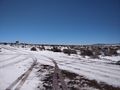
Turn off to the hash
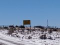
Ominous sign
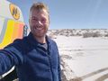
The hash-van
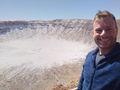
Meteor Crater instead of hash


Achievements
Felix Dance earned the There might be alligators! consolation prize
|
Felix Dance earned the Prize poultry Consolation Prize
|