Difference between revisions of "2022-03-18 48 11"
From Geohashing
m (→Participants) |
(→Photos) |
||
| (One intermediate revision by the same user not shown) | |||
| Line 3: | Line 3: | ||
| lon={{#explode:{{SUBPAGENAME}}| |2}} | | lon={{#explode:{{SUBPAGENAME}}| |2}} | ||
| date={{#explode:{{SUBPAGENAME}}| |0}} | | date={{#explode:{{SUBPAGENAME}}| |0}} | ||
| − | }} | + | }} |
| + | |||
__NOTOC__ | __NOTOC__ | ||
| + | |||
== Location == | == Location == | ||
| − | + | On a field south of the Danube somewhere between Ingolstadt and Vohburg. | |
== Participants == | == Participants == | ||
| Line 12: | Line 14: | ||
== Plans == | == Plans == | ||
| − | + | I was in Ingolstadt that day and realized that the hash was close by. So I planned to drive there after work. | |
== Expedition == | == Expedition == | ||
| − | + | Already the drive along the "Alte Donau" (Old Danube) was really beautiful and I've seen a lot of birds, including the first Storks this year. I parked my car on a gravel road a few yards from the hashpoint and walked to it over the (barren) field. | |
| − | |||
| − | |||
| − | |||
== Photos == | == Photos == | ||
| − | |||
| − | |||
| − | |||
<gallery perrow="5"> | <gallery perrow="5"> | ||
| + | Image:2022-03-18_48_11_Solli_01.jpg | Nearby pond | ||
| + | Image:2022-03-18_48_11_Solli_02.jpg | Being out standing in my field | ||
| + | Image:2022-03-18_48_11_Solli_03.jpg | Stupid Grin™ | ||
| + | Image:2022-03-18_48_11_Solli_04.jpg | Proof | ||
| + | Image:2022-03-18_48_11_Solli_05.jpg | The Vohburg refinery viewed from the hashpoint | ||
</gallery> | </gallery> | ||
== Achievements == | == Achievements == | ||
{{#vardefine:ribbonwidth|800px}} | {{#vardefine:ribbonwidth|800px}} | ||
| − | + | {{land geohash | |
| − | + | | latitude = 48 | |
| − | + | | longitude = 11 | |
| − | + | | date = 2022-03-18 | |
| − | + | | name = Solli | |
| + | }} | ||
| − | |||
| − | |||
| − | |||
| − | |||
| − | |||
| − | |||
| − | |||
| − | |||
| − | |||
| − | |||
[[Category:Expeditions]] | [[Category:Expeditions]] | ||
| − | |||
[[Category:Expeditions with photos]] | [[Category:Expeditions with photos]] | ||
| − | |||
| − | |||
| − | |||
| − | |||
| − | |||
[[Category:Coordinates reached]] | [[Category:Coordinates reached]] | ||
| − | + | {{location|DE|BY|PAF}} | |
| − | |||
| − | |||
| − | |||
| − | |||
| − | |||
| − | |||
| − | |||
| − | |||
| − | |||
| − | |||
| − | |||
| − | |||
| − | |||
| − | |||
| − | |||
| − | |||
| − | |||
Latest revision as of 13:09, 4 May 2022
| Fri 18 Mar 2022 in 48,11: 48.7495326, 11.5720502 geohashing.info google osm bing/os kml crox |
Location
On a field south of the Danube somewhere between Ingolstadt and Vohburg.
Participants
Plans
I was in Ingolstadt that day and realized that the hash was close by. So I planned to drive there after work.
Expedition
Already the drive along the "Alte Donau" (Old Danube) was really beautiful and I've seen a lot of birds, including the first Storks this year. I parked my car on a gravel road a few yards from the hashpoint and walked to it over the (barren) field.
Photos
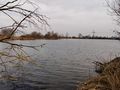
Nearby pond
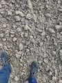
Being out standing in my field

Stupid Grin™
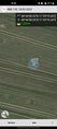
Proof
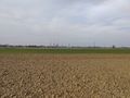
The Vohburg refinery viewed from the hashpoint


Achievements
Solli earned the Land geohash achievement
|