Difference between revisions of "2022-03-26 52 13"
(Expedition report) |
m (uncommenting categories) |
||
| (One intermediate revision by one other user not shown) | |||
| Line 39: | Line 39: | ||
</gallery> | </gallery> | ||
| − | <!-- =============== USEFUL CATEGORIES FOLLOW ================ | + | <!-- =============== USEFUL CATEGORIES FOLLOW ================--> |
[[Category:Expeditions]] | [[Category:Expeditions]] | ||
[[Category:Expeditions with photos]] | [[Category:Expeditions with photos]] | ||
[[Category:Coordinates reached]] | [[Category:Coordinates reached]] | ||
| + | {{location|DE|BB|OHV}} | ||
Latest revision as of 22:35, 26 March 2022

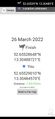
| Sat 26 Mar 2022 in 52,13: 52.6552865, 13.3048872 geohashing.info google osm bing/os kml crox |
Location
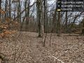
Where the German wall used to be, in a forest on the Berlin Brandenburg border.
Participants
Plans
12km from home, so no real plans except for stepping out the door and cycling there.
Expedition
I had intended to be there at 4pm for the meetup time (despite the unlikeliness of anybody else being there), but I was late due to the special gravity field of my couch. The trip there was uneventful: grey weather, but pleasant temperatures, and a lot of people out and about.
The place itself was 10m off the Berlin Wall path that allows people to hike/cycle the entire length of where the Berlin Wall used to be. Took a picture and then followed the path some more before heading back home.
Photos
Berlin Brandenburg border forest
Slightly late @52.6553,13.3049
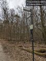
The Berlin Wall cycleway, 10m from the hashpoint

