Difference between revisions of "2022-03-27 58 5"
From Geohashing
(→Location) |
(→Achievements) |
||
| (10 intermediate revisions by 3 users not shown) | |||
| Line 15: | Line 15: | ||
== Location == | == Location == | ||
<!-- where you've surveyed the hash to be --> | <!-- where you've surveyed the hash to be --> | ||
| − | Jåttå | + | On a cultivated meadow at Jåttå in Stavanger, Norway |
== Participants == | == Participants == | ||
<!-- who attended: If you link to your wiki user name in this section, your expedition will be picked up by the various statistics generated for geohashing. You may use three tildes ~ as a shortcut to automatically insert the user signature of the account you are editing with. | <!-- who attended: If you link to your wiki user name in this section, your expedition will be picked up by the various statistics generated for geohashing. You may use three tildes ~ as a shortcut to automatically insert the user signature of the account you are editing with. | ||
--> | --> | ||
| − | Pica42 | + | *[[User:Pica42|Pica42]] |
| − | |||
| − | |||
| − | |||
== Expedition == | == Expedition == | ||
<!-- how it all turned out. your narrative goes here. --> | <!-- how it all turned out. your narrative goes here. --> | ||
A morning trip to Jåttå, Stavanger, Norway on a slightly gray Sunday. The meadow was covered with natural fertilizer. | A morning trip to Jåttå, Stavanger, Norway on a slightly gray Sunday. The meadow was covered with natural fertilizer. | ||
| − | |||
| − | |||
| − | |||
== Photos == | == Photos == | ||
| Line 38: | Line 32: | ||
<gallery perrow="5"> | <gallery perrow="5"> | ||
| − | Image:2022-03-27_58_5_Pica42_1648368182213.jpg| | + | Image:2022-03-27_58_5_Pica42_1648368182213.jpg|A trip to Jåttå [https://openstreetmap.org/?mlat=58.91787760&mlon=5.71182900&zoom=16 @58.9179,5.7118] |
| − | |||
| − | |||
| − | |||
3 Jåttå.jpg|View to the west. | 3 Jåttå.jpg|View to the west. | ||
2 Jåttå.jpg|View to the north. | 2 Jåttå.jpg|View to the north. | ||
| Line 52: | Line 43: | ||
<!-- Add any achievement ribbons you earned below, or remove this section --> | <!-- Add any achievement ribbons you earned below, or remove this section --> | ||
| − | |||
| − | |||
| − | |||
| − | |||
| − | |||
| − | |||
| − | |||
| − | |||
| − | |||
| − | |||
| − | |||
| − | |||
| − | |||
| − | |||
[[Category:Expeditions]] | [[Category:Expeditions]] | ||
| − | |||
[[Category:Expeditions with photos]] | [[Category:Expeditions with photos]] | ||
| − | |||
| − | |||
| − | |||
| − | |||
| − | |||
[[Category:Coordinates reached]] | [[Category:Coordinates reached]] | ||
| + | {{location|NO|11}} | ||
| + | {{land geohash |name=[[User:Pica42|Pica42]] |date=2022-03-27 |latitude=58 |longitude=5 }} | ||
| − | + | {{Last man standing | |
| − | + | | latitude = 58 | |
| − | -- | + | | longitude = 5 |
| − | + | | date = 2022-03-27 | |
| − | + | | gender = man | |
| − | + | | name = [[User:Pica42|Pica42]] | |
| − | + | }} | |
| − | [[ | ||
| − | |||
| − | |||
| − | |||
| − | |||
| − | |||
| − | |||
| − | |||
| − | |||
Latest revision as of 16:19, 19 November 2022
| Sun 27 Mar 2022 in 58,5: 58.9178479, 5.7118457 geohashing.info google osm bing/os kml crox |
Location
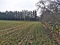
On a cultivated meadow at Jåttå in Stavanger, Norway
Participants
Expedition
A morning trip to Jåttå, Stavanger, Norway on a slightly gray Sunday. The meadow was covered with natural fertilizer.
Photos

A trip to Jåttå @58.9179,5.7118
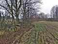
View to the west.

View to the north.
View to the east.


Achievements
Pica42 earned the Land geohash achievement
|
Pica42 earned the Last man standing achievement
|