Difference between revisions of "2022-04-01 47 -122"
([live picture]Western end [https://openstreetmap.org/?mlat=47.77301297&mlon=-122.37840597&zoom=16 @47.7730,-122.3784]) |
|||
| Line 1: | Line 1: | ||
| − | + | {{meetup graticule | |
| − | |||
| − | |||
| − | |||
| − | |||
| − | |||
| − | |||
| − | |||
| − | |||
| lat=47 | | lat=47 | ||
| lon=-122 | | lon=-122 | ||
| date=2022-04-01 | | date=2022-04-01 | ||
| + | | graticule_name=Seattle | ||
| + | | graticule_link=Seattle, Washington | ||
}}<!-- edit as necessary --> | }}<!-- edit as necessary --> | ||
__NOTOC__ | __NOTOC__ | ||
== Location == | == Location == | ||
| − | + | On Richmond Beach access pathway, close to a park and a bowling alley. | |
== Participants == | == Participants == | ||
| − | + | * [[User:Thomcat|Thomcat]] | |
| − | |||
== Plans == | == Plans == | ||
| − | + | Stop by after work, in this case a baseball game | |
== Expedition == | == Expedition == | ||
| − | + | This one was dead easy, if the google maps were accurate. Between a culdesac and a main road, an access pathway, leading uphill west to east. | |
| + | |||
| + | After a frustrating game I stopped at the bowling alley / tap room first for a well needed pint. I should have checked in there for geohashing, but alas, no. A short drive around the corner (yes, I could have walked in the slight rain) led right to an easy parking spot. | ||
| + | |||
| + | I snapped a picture of the entrance, the path way, and landed spot on easily enough. I then walked down to snap a pic from the west end also. I did not bring the chalk, but the light rain would wipe that out soon enough. +1 success. | ||
== Tracklog == | == Tracklog == | ||
| Line 48: | Line 45: | ||
<!-- Add any achievement ribbons you earned below, or remove this section --> | <!-- Add any achievement ribbons you earned below, or remove this section --> | ||
| − | |||
| − | |||
| − | |||
| − | |||
| − | |||
| − | |||
| − | |||
| − | |||
| − | |||
| − | |||
| − | |||
| − | |||
| − | |||
| − | |||
[[Category:Expeditions]] | [[Category:Expeditions]] | ||
| − | |||
[[Category:Expeditions with photos]] | [[Category:Expeditions with photos]] | ||
| − | |||
| − | |||
| − | |||
| − | |||
| − | |||
[[Category:Coordinates reached]] | [[Category:Coordinates reached]] | ||
| − | + | {{location|US|WA|KN}} | |
| − | |||
| − | |||
| − | |||
| − | |||
| − | |||
| − | |||
| − | |||
| − | |||
| − | |||
| − | |||
| − | |||
| − | |||
| − | |||
| − | |||
| − | |||
| − | |||
| − | |||
Latest revision as of 19:59, 2 April 2022
| Fri 1 Apr 2022 in Seattle: 47.7729124, -122.3780281 geohashing.info google osm bing/os kml crox |
Location
On Richmond Beach access pathway, close to a park and a bowling alley.
Participants
Plans
Stop by after work, in this case a baseball game
Expedition
This one was dead easy, if the google maps were accurate. Between a culdesac and a main road, an access pathway, leading uphill west to east.
After a frustrating game I stopped at the bowling alley / tap room first for a well needed pint. I should have checked in there for geohashing, but alas, no. A short drive around the corner (yes, I could have walked in the slight rain) led right to an easy parking spot.
I snapped a picture of the entrance, the path way, and landed spot on easily enough. I then walked down to snap a pic from the west end also. I did not bring the chalk, but the light rain would wipe that out soon enough. +1 success.
Tracklog
Photos
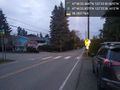
Eastern end @47.7730,-122.3773
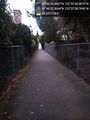
Walkway @47.7729,-122.3774
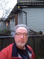
geohasher @47.7729,-122.3780
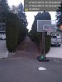
Western end @47.7730,-122.3784


