Difference between revisions of "2022-04-24 49 8"
From Geohashing
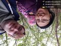
([live picture]been there! [https://openstreetmap.org/?mlat=49.88025180&mlon=8.60908510&zoom=16 @49.8803,8.6091]) |
m (Location) |
||
| (One intermediate revision by one other user not shown) | |||
| Line 15: | Line 15: | ||
== Location == | == Location == | ||
<!-- where you've surveyed the hash to be --> | <!-- where you've surveyed the hash to be --> | ||
| + | This Geohash is located in a forest in Darmstadt. | ||
== Participants == | == Participants == | ||
<!-- who attended: If you link to your wiki user name in this section, your expedition will be picked up by the various statistics generated for geohashing. You may use three tildes ~ as a shortcut to automatically insert the user signature of the account you are editing with. | <!-- who attended: If you link to your wiki user name in this section, your expedition will be picked up by the various statistics generated for geohashing. You may use three tildes ~ as a shortcut to automatically insert the user signature of the account you are editing with. | ||
--> | --> | ||
| + | * [[User:Rincewind|Rincewind]] | ||
| + | * [[User:Yakamoz|Yakamoz]] | ||
| + | * TheOffspring | ||
== Plans == | == Plans == | ||
| Line 42: | Line 46: | ||
<!-- Add any achievement ribbons you earned below, or remove this section --> | <!-- Add any achievement ribbons you earned below, or remove this section --> | ||
| − | |||
| − | |||
| − | |||
| − | |||
| − | |||
| − | |||
| − | |||
| − | |||
| − | |||
| − | |||
| − | |||
| − | |||
| − | |||
| − | |||
[[Category:Expeditions]] | [[Category:Expeditions]] | ||
| − | |||
[[Category:Expeditions with photos]] | [[Category:Expeditions with photos]] | ||
| − | |||
| − | |||
| − | |||
| − | |||
| − | |||
[[Category:Coordinates reached]] | [[Category:Coordinates reached]] | ||
| − | + | {{location|DE|HE|DA|city=true}} | |
| − | |||
| − | |||
| − | |||
| − | |||
| − | |||
| − | |||
| − | |||
| − | |||
| − | |||
| − | |||
| − | |||
| − | |||
| − | |||
| − | |||
| − | |||
| − | |||
| − | |||
Latest revision as of 19:42, 28 May 2022
| Sun 24 Apr 2022 in 49,8: 49.8801597, 8.6094685 geohashing.info google osm bing/os kml crox |
Location
This Geohash is located in a forest in Darmstadt.
Participants
Plans
Expedition
Tracklog
Photos
been there! @49.8803,8.6091
