Difference between revisions of "2022-04-25 50 7"
Gefrierbrand (talk | contribs) (→Photos) |
Gefrierbrand (talk | contribs) |
||
| Line 1: | Line 1: | ||
| − | + | {{meetup graticule | |
| − | |||
| − | |||
| − | |||
| − | |||
| − | |||
| − | |||
| − | |||
| − | |||
| lat=50 | | lat=50 | ||
| lon=7 | | lon=7 | ||
| date=2022-04-25 | | date=2022-04-25 | ||
| − | }} | + | }} |
__NOTOC__ | __NOTOC__ | ||
== Location == | == Location == | ||
| − | + | Beside a wind turbine near Buchholz | |
== Participants == | == Participants == | ||
| − | + | * [[User:Gefrierbrand|Gefrierbrand]] | |
| − | |||
| − | |||
| − | |||
| − | |||
== Expedition == | == Expedition == | ||
| − | + | The has was very close to the Autobahn A61 on which I was traveling anyways. Moreover it was near to an exit and also right next to a huge wind turbine, which made it almost unmissable. | |
| + | I parked a few hundred meters away and walked towards the hashlocation with the turbine as my guide. I had to deviate from the paths a bit to get to the actual location in the forest, but there were nice, fresh paths and very good GPS reception, so it was terribly easy to reach this hash. | ||
| − | + | Near to the turbine, several signs warned about the dangers of falling ice from it, but since the temperatures were well over 15 °C I had nothing to fear and got up close to the turbine looking up to its massive and impressive wings from below before returning to my car and continuing home. | |
| − | |||
| − | |||
== Photos == | == Photos == | ||
| Line 45: | Line 32: | ||
== Achievements == | == Achievements == | ||
{{#vardefine:ribbonwidth|800px}} | {{#vardefine:ribbonwidth|800px}} | ||
| − | + | {{land geohash | |
| − | + | | latitude = 50 | |
| − | + | | longitude =7 | |
| − | + | | date =2022-04-25 | |
| − | + | | name = Gefrierbrand | |
| − | + | }} | |
| − | + | {{Easy_geohash | |
| − | + | | latitude = 50 | |
| − | + | | longitude =7 | |
| − | + | | date =2022-04-25 | |
| − | + | | name = Gefrierbrand | |
| − | + | }} | |
| − | |||
| − | |||
[[Category:Expeditions]] | [[Category:Expeditions]] | ||
| − | |||
[[Category:Expeditions with photos]] | [[Category:Expeditions with photos]] | ||
| − | |||
| − | |||
| − | |||
| − | |||
| − | |||
[[Category:Coordinates reached]] | [[Category:Coordinates reached]] | ||
| − | |||
| − | |||
| − | |||
| − | |||
| − | |||
| − | |||
| − | |||
| − | |||
| − | |||
| − | |||
| − | |||
| − | |||
| − | |||
| − | |||
| − | |||
| − | |||
| − | |||
| − | |||
Revision as of 18:46, 25 April 2022
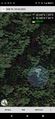
| Mon 25 Apr 2022 in 50,7: 50.2004389, 7.5606666 geohashing.info google osm bing/os kml crox |
Location
Beside a wind turbine near Buchholz
Participants
Expedition
The has was very close to the Autobahn A61 on which I was traveling anyways. Moreover it was near to an exit and also right next to a huge wind turbine, which made it almost unmissable.
I parked a few hundred meters away and walked towards the hashlocation with the turbine as my guide. I had to deviate from the paths a bit to get to the actual location in the forest, but there were nice, fresh paths and very good GPS reception, so it was terribly easy to reach this hash.
Near to the turbine, several signs warned about the dangers of falling ice from it, but since the temperatures were well over 15 °C I had nothing to fear and got up close to the turbine looking up to its massive and impressive wings from below before returning to my car and continuing home.
Photos
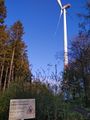
warning ice
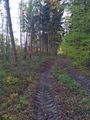
easy walking
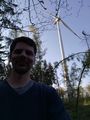
StupidGrinTM
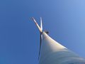
134 m to the hub
proof


Achievements
Gefrierbrand earned the Land geohash achievement
|
Gefrierbrand has visited an Easy Geohash
|