Difference between revisions of "2022-04-30 58 5"
From Geohashing
(→Photos) |
(→Achievements) |
||
| (13 intermediate revisions by 3 users not shown) | |||
| Line 1: | Line 1: | ||
| − | + | {{meetup graticule | |
| − | |||
| − | |||
| − | |||
| − | |||
| − | |||
| − | |||
| − | |||
| − | |||
| lat=58 | | lat=58 | ||
| lon=5 | | lon=5 | ||
| date=2022-04-30 | | date=2022-04-30 | ||
}}<!-- edit as necessary --> | }}<!-- edit as necessary --> | ||
| − | + | [[Image:20220430_090533.jpg|thumb|left]] | |
== Location == | == Location == | ||
<!-- where you've surveyed the hash to be --> | <!-- where you've surveyed the hash to be --> | ||
| Line 20: | Line 12: | ||
<!-- who attended: If you link to your wiki user name in this section, your expedition will be picked up by the various statistics generated for geohashing. You may use three tildes ~ as a shortcut to automatically insert the user signature of the account you are editing with. | <!-- who attended: If you link to your wiki user name in this section, your expedition will be picked up by the various statistics generated for geohashing. You may use three tildes ~ as a shortcut to automatically insert the user signature of the account you are editing with. | ||
--> | --> | ||
| − | Pica42 | + | *[[User:Pica42|Pica42]] |
| − | |||
| − | |||
| − | |||
== Expedition == | == Expedition == | ||
<!-- how it all turned out. your narrative goes here. --> | <!-- how it all turned out. your narrative goes here. --> | ||
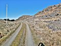
| − | + | I took the trip early in the morning in beautiful weather. From where I parked it was about 500 meters to walk on a tractor road to the hash at 250 meters above sea level. | |
| − | |||
| − | |||
== Photos == | == Photos == | ||
| Line 37: | Line 24: | ||
<gallery perrow="5"> | <gallery perrow="5"> | ||
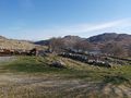
| − | Image:2022-04-30_58_5_Pica42_1651302211222.jpg| | + | Image:2022-04-30_58_5_Pica42_1651302211222.jpg|Fløymeland [https://openstreetmap.org/?mlat=58.65025750&mlon=5.81817990&zoom=16 @58.6503,5.8182] |
| − | Image:20220430 090353.jpg| | + | Image:20220430 090353.jpg|View to the northeast. |
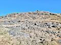
| − | Image:20220430_114959.jpg| | + | Image:20220430_114959.jpg|View to the west. |
| − | + | Image:20220430_115115.jpg|View to the northwest. | |
</gallery> | </gallery> | ||
| Line 47: | Line 34: | ||
<!-- Add any achievement ribbons you earned below, or remove this section --> | <!-- Add any achievement ribbons you earned below, or remove this section --> | ||
| − | |||
| − | |||
| − | |||
| − | |||
| − | |||
| − | |||
| − | |||
| − | |||
| − | |||
| − | |||
| − | |||
| − | |||
| − | |||
| − | |||
[[Category:Expeditions]] | [[Category:Expeditions]] | ||
| − | |||
[[Category:Expeditions with photos]] | [[Category:Expeditions with photos]] | ||
| − | |||
| − | |||
| − | |||
| − | |||
| − | |||
[[Category:Coordinates reached]] | [[Category:Coordinates reached]] | ||
| + | __NOTOC__ | ||
| + | {{location|NO|11}} | ||
| − | + | {{land geohash |name=[[User:Pica42|Pica42]] |date=2022-04-30 |latitude=58 |longitude=5 }} | |
| − | |||
| − | |||
| − | |||
| − | |||
| − | |||
| − | |||
| − | |||
| − | |||
| − | |||
| − | |||
| − | |||
| − | |||
| − | |||
| − | [[ | ||
| − | |||
| − | |||
Latest revision as of 13:04, 20 July 2022
| Sat 30 Apr 2022 in 58,5: 58.6502938, 5.8181929 geohashing.info google osm bing/os kml crox |

Location
Fløymeland in Time, Norway
Participants
Expedition
I took the trip early in the morning in beautiful weather. From where I parked it was about 500 meters to walk on a tractor road to the hash at 250 meters above sea level.
Photos
Fløymeland @58.6503,5.8182
View to the northeast.
View to the west.
View to the northwest.


Achievements
Pica42 earned the Land geohash achievement
|