Difference between revisions of "2022-05-05 -37 145"
Felix Dance (talk | contribs) (An expedition message sent via Geohash Droid for Android.) |
m (Location) |
||
| (12 intermediate revisions by 2 users not shown) | |||
| Line 1: | Line 1: | ||
| − | + | [[Image:{{{image|2022-05-05_-37_145_Felix Dance_1651719653032.jpg}}}|thumb|left]] | |
| − | + | {{meetup graticule | |
| − | [[Image:{{{image| | ||
| − | |||
| − | |||
| − | |||
| − | |||
| − | |||
| − | |||
| lat=-37 | | lat=-37 | ||
| lon=145 | | lon=145 | ||
| date=2022-05-05 | | date=2022-05-05 | ||
| − | }} | + | }} |
| + | |||
__NOTOC__ | __NOTOC__ | ||
== Location == | == Location == | ||
| − | + | On a steep footpath in Boronia. | |
== Participants == | == Participants == | ||
| − | + | *[[User:Felix Dance|Felix Dance]] | |
| − | + | ||
| + | == Expedition == | ||
| + | Neat little hash this one. I woke up to [[User:Stevage|Stevage]]'s message in the group chat saying the hash was in Boronia. I had a look and it was also accessible, just on a footpath. So I got ready and headed off on my bike. | ||
| − | + | Using my road bike for maximum speed I hurled myself towards the Eastern Suburbs. I took a lot of roads rather than the more salubrious Koonung Trail and negotiated a few diagonals to take advantage of the hypotenuses. | |
| − | |||
| − | + | And soon I was screaming down the last hill, battling the irritatingly long traffic sequence at the Dorset Rd/Boronia Rd intersection and then onto the residential streets to the hash. I overshot slightly since I was focused on climbing the pretty-steep street, but then turned around and almost immediately hit the jackpot with the hash. | |
| − | + | ||
| + | I took some photos and returned on the train. | ||
== Tracklog == | == Tracklog == | ||
| − | + | {{ Tracklog | Geohash 2022-05-05 -37 145 Boronia.gpx }} | |
== Photos == | == Photos == | ||
| − | |||
| − | |||
| − | |||
<gallery perrow="5"> | <gallery perrow="5"> | ||
| + | |||
| + | Image:2022-05-05_-37_145_Felix Dance_1651719653032.jpg|Geohash success! | ||
| + | |||
| + | Image:2022-05-05_-37_145_Felix Dance_1651719668561.jpg|Up the street | ||
| + | |||
| + | Image:2022-05-05_-37_145_Felix Dance_1651719679741.jpg|Hash tree | ||
| + | |||
| + | Image:2022-05-05_-37_145_Felix Dance_1651719700698.jpg|GPS proof | ||
</gallery> | </gallery> | ||
== Achievements == | == Achievements == | ||
| − | {{ | + | {{bicycle geohash |
| − | |||
| − | + | | latitude = -37 | |
| − | + | | longitude = 145 | |
| − | [[ | + | | date = 2022-05-05 |
| + | | name = [[User:Felix Dance|Felix Dance]] | ||
| + | | distance = 38 kms | ||
| + | | bothways = false | ||
| + | | image = 2022-05-05_-37_145_Felix Dance_1651719653032.jpg | ||
| − | + | }} | |
| − | + | {{#vardefine:ribbonwidth|800px}} | |
| − | |||
| − | |||
| − | |||
| − | |||
| − | |||
| − | |||
| − | |||
[[Category:Expeditions]] | [[Category:Expeditions]] | ||
| − | |||
[[Category:Expeditions with photos]] | [[Category:Expeditions with photos]] | ||
| − | |||
| − | |||
| − | |||
| − | |||
| − | |||
[[Category:Coordinates reached]] | [[Category:Coordinates reached]] | ||
| − | + | {{location|AU|VIC|KN}} | |
| − | |||
| − | |||
| − | |||
| − | |||
| − | |||
| − | |||
| − | |||
| − | |||
| − | |||
| − | |||
| − | |||
| − | |||
| − | |||
| − | |||
| − | |||
| − | |||
| − | |||
Latest revision as of 09:43, 17 May 2022

| Thu 5 May 2022 in -37,145: -37.8674755, 145.2885623 geohashing.info google osm bing/os kml crox |
Location
On a steep footpath in Boronia.
Participants
Expedition
Neat little hash this one. I woke up to Stevage's message in the group chat saying the hash was in Boronia. I had a look and it was also accessible, just on a footpath. So I got ready and headed off on my bike.
Using my road bike for maximum speed I hurled myself towards the Eastern Suburbs. I took a lot of roads rather than the more salubrious Koonung Trail and negotiated a few diagonals to take advantage of the hypotenuses.
And soon I was screaming down the last hill, battling the irritatingly long traffic sequence at the Dorset Rd/Boronia Rd intersection and then onto the residential streets to the hash. I overshot slightly since I was focused on climbing the pretty-steep street, but then turned around and almost immediately hit the jackpot with the hash.
I took some photos and returned on the train.
Tracklog
Photos
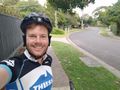
Geohash success!
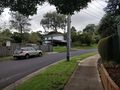
Up the street
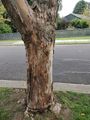
Hash tree
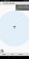
GPS proof


Achievements
Felix Dance earned the Bicycle geohash achievement
|