Difference between revisions of "2022-05-12 48 11"
m (→Participants) |
|||
| (3 intermediate revisions by 2 users not shown) | |||
| Line 8: | Line 8: | ||
== Participants == | == Participants == | ||
| − | * [[User:Solli|Solli]] | + | * [[User:Solli|Solli]], Shany the Hashdog |
== Plans == | == Plans == | ||
| Line 14: | Line 14: | ||
== Expedition == | == Expedition == | ||
| − | + | The Regatta Course was built for the 1972 Olympic Games and it is now a popular course for rowing and canoeing. Around the water basin there is a paved path that is used as a track for cyclists and inline skaters. So on a sunny evening like this there were quite a few people around. | |
| − | + | I parked my car on the northern end and walked to the hashpoint on the north-western side of the course. As it turned out, the point was a few yards away from the shore in a little wood or rather shrubbery. However Mother Nature could not keep me from reaching the point. | |
| − | |||
== Photos == | == Photos == | ||
| − | |||
| − | |||
| − | |||
<gallery perrow="5"> | <gallery perrow="5"> | ||
| + | Image:2022-05-12_48_11_Solli_01.jpg | An evening on the Regatta Course | ||
| + | Image:2022-05-12_48_11_Solli_02.jpg | Shany the Hashdog | ||
| + | Image:2022-05-12_48_11_Solli_03.jpg | The tribune of the 1972 Olympics | ||
| + | Image:2022-05-12_48_11_Solli_04.jpg | Proof | ||
| + | Image:2022-05-12_48_11_Solli_05.jpg | Stupid Grin™ | ||
| + | Image:2022-05-12_48_11_Solli_06.jpg | The Hashpoint | ||
| + | Image:2022-05-12_48_11_Solli_07.jpg | On the way back | ||
</gallery> | </gallery> | ||
== Achievements == | == Achievements == | ||
{{#vardefine:ribbonwidth|800px}} | {{#vardefine:ribbonwidth|800px}} | ||
| − | + | {{land geohash | |
| + | | latitude = 48 | ||
| + | | longitude = 11 | ||
| + | | date = 2022-05-12 | ||
| + | | name = Solli | ||
| + | }} | ||
| − | |||
| − | |||
| − | |||
| − | |||
| − | |||
| − | |||
| − | |||
| − | |||
| − | |||
| − | |||
| − | |||
| − | |||
| − | |||
| − | |||
[[Category:Expeditions]] | [[Category:Expeditions]] | ||
| − | |||
[[Category:Expeditions with photos]] | [[Category:Expeditions with photos]] | ||
| − | |||
| − | |||
| − | |||
| − | |||
| − | |||
[[Category:Coordinates reached]] | [[Category:Coordinates reached]] | ||
| − | + | {{location|DE|BY|M}} | |
| − | |||
| − | |||
| − | |||
| − | |||
| − | |||
| − | |||
| − | |||
| − | |||
| − | |||
| − | |||
| − | |||
| − | |||
| − | |||
| − | |||
| − | |||
| − | |||
| − | |||
Latest revision as of 12:41, 18 May 2022
| Thu 12 May 2022 in 48,11: 48.2453924, 11.5161617 geohashing.info google osm bing/os kml crox |
Location
Near the Oberschleißheim Regatta Course
Participants
- Solli, Shany the Hashdog
Plans
I'm going to give it a try in the evening. It seems pretty accessible and the weather is also nice for a little walk at the Regatta Course.
Expedition
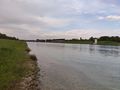
The Regatta Course was built for the 1972 Olympic Games and it is now a popular course for rowing and canoeing. Around the water basin there is a paved path that is used as a track for cyclists and inline skaters. So on a sunny evening like this there were quite a few people around.
I parked my car on the northern end and walked to the hashpoint on the north-western side of the course. As it turned out, the point was a few yards away from the shore in a little wood or rather shrubbery. However Mother Nature could not keep me from reaching the point.
Photos
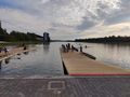
An evening on the Regatta Course
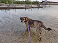
Shany the Hashdog
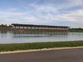
The tribune of the 1972 Olympics

Proof

Stupid Grin™
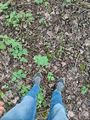
The Hashpoint
On the way back


Achievements
Solli earned the Land geohash achievement
|