Difference between revisions of "2022-05-15 52 9"
(Planning new expedition) |
m |
||
| (4 intermediate revisions by 3 users not shown) | |||
| Line 1: | Line 1: | ||
| − | + | {{meetup graticule|date=2022-05-15|lat=52|lon=9}} | |
| + | ==Location== | ||
| + | This Geohash is located on Memeler Straße in [[wikipedia:Hannover|Hannover-Bothfeld]]. | ||
| − | [[ | + | ==Participants== |
| + | *[[User:DLichti|DLichti]] | ||
| + | *[[User:GeorgDerReisende|GeorgDerReisende]] | ||
| + | *[[User:Fippe|Fippe]] | ||
| − | + | ==Plans== | |
| − | + | ===DLichti=== | |
| + | Take the tram to ''Alte Heide'' and be at the location at 16:00. | ||
| − | + | ==Expedition== | |
| − | + | ===DLichti=== | |
| − | + | I arrived at the ''Alte Heide'' tram station at 15:25 on a warm and sunny afternoon. | |
| − | + | Since there was ample time to reach the location, I wandered around doing some OSM mapping in the vicinity. | |
| − | + | Half an hour later, I found myself in front of a car parked right on the geohash. | |
| − | + | But thanks to GPS noise, I still managed to get a 0m screenshot. | |
| − | + | GeorgDerReisende arrived a few minutes later, just before hash o'clock. | |
| − | == | + | Since we had not heard of anyone else, we left quite soon. |
| − | + | After some more mapping, I took the tram home. | |
| − | |||
| − | |||
| − | |||
| − | |||
| − | |||
| − | |||
| − | |||
| − | == | + | ===Fippe=== |
| − | + | {{User:Fippe/Spree|2022-05-07}} | |
| − | + | From Berlin, I took the train to Hannover and cycled the rest of the distance, part of the route went through the Eilenriede forest. In the parking lot at the destination, I located the coordinates and recorded proof. Afterwards, I cycled home, returning for the first time after thirteen expeditions in nine days. | |
| − | |||
| − | == Photos == | + | ==Photos== |
| − | + | ===Fippe=== | |
| − | + | [[File:2022-05-15 52 9 03 Surroundings.jpg|Surroundings|1000px]] | |
| − | -- | + | <gallery> |
| − | + | 2022-05-15 52 9 01 Proof.jpg | Proof | |
| + | 2022-05-15 52 9 02 Geohash.jpg | The Geohash | ||
| + | 2022-05-15 52 9 04 Site.jpg | The site of the Geohash | ||
</gallery> | </gallery> | ||
| − | == | + | ==Ribbons== |
| − | {{#vardefine:ribbonwidth| | + | {{#vardefine:ribbonwidth|100%}} |
| − | + | {{land geohash|date=2022-05-15|latitude=52|longitude=9|name=[[User:DLichti|DLichti]], [[User:GeorgDerReisende|GeorgDerReisende]] and [[User:Fippe|Fippe]]|image=2022-05-15 52 9 02 Geohash.jpg}} | |
| + | {{xkcd-100-Honorable-Mention|date=2022-05-15|latitude=52|longitude=9|distance=240 km|name=[[User:Fippe|Fippe]]}} | ||
| + | {{consecutive geohash 3|hashcount=13|daycount=9|date=2022-05-07|latitude=52|longitude=13|name=[[User:Fippe|Fippe]]}} | ||
| − | + | __NOTOC__ | |
| − | |||
| − | |||
| − | |||
| − | |||
| − | |||
| − | |||
| − | |||
| − | |||
| − | |||
| − | |||
| − | |||
| − | |||
| − | |||
[[Category:Expeditions]] | [[Category:Expeditions]] | ||
| − | + | [[Category:Coordinates reached]] | |
[[Category:Expeditions with photos]] | [[Category:Expeditions with photos]] | ||
| − | + | {{location|DE|NI|H}} | |
| − | + | {{user categories|user=Fippe|bike=18|train=254|hours=11}} | |
| − | |||
| − | |||
| − | |||
| − | |||
| − | |||
| − | |||
| − | |||
| − | |||
| − | |||
| − | |||
| − | |||
| − | |||
| − | |||
| − | |||
| − | |||
| − | |||
| − | |||
| − | |||
| − | |||
| − | |||
| − | |||
| − | |||
Latest revision as of 17:12, 21 March 2023
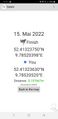
| Sun 15 May 2022 in 52,9: 52.4132375, 9.7852040 geohashing.info google osm bing/os kml crox |
Location
This Geohash is located on Memeler Straße in Hannover-Bothfeld.
Participants
Plans
DLichti
Take the tram to Alte Heide and be at the location at 16:00.
Expedition
DLichti
I arrived at the Alte Heide tram station at 15:25 on a warm and sunny afternoon. Since there was ample time to reach the location, I wandered around doing some OSM mapping in the vicinity. Half an hour later, I found myself in front of a car parked right on the geohash. But thanks to GPS noise, I still managed to get a 0m screenshot. GeorgDerReisende arrived a few minutes later, just before hash o'clock. Since we had not heard of anyone else, we left quite soon. After some more mapping, I took the tram home.
Fippe
First trip to Berlin
SeegefeldJ ·
WustJ ·
MünchehofeJ ·
Berlin‑Nikolassee ·
Bochow ·
Sacrow ·
Babitz ·
Templin ·
Libbesdorf ·
Gryfino ·
Kleßen ·
BeelitzJ ·
Hannover‑Bothfeld
J: with Jan
From Berlin, I took the train to Hannover and cycled the rest of the distance, part of the route went through the Eilenriede forest. In the parking lot at the destination, I located the coordinates and recorded proof. Afterwards, I cycled home, returning for the first time after thirteen expeditions in nine days.
Photos
Fippe

Proof
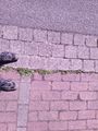
The Geohash
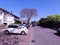
The site of the Geohash


Ribbons
DLichti, GeorgDerReisende and Fippe earned the Land geohash achievement
|
Fippe earned the XKCD-100 Honorable Mention Achievement
|
Fippe earned the Consecutive geohash achievement
|