Difference between revisions of "2022-06-03 52 4"
(Created page with "{{subst:Expedition}}") |
m (Location) |
||
| (8 intermediate revisions by 2 users not shown) | |||
| Line 1: | Line 1: | ||
| − | + | {{meetup graticule | |
| + | | lat=52 | ||
| + | | lon=4 | ||
| + | | date=2022-06-03 | ||
| + | }} | ||
| − | |||
| − | |||
| − | |||
| − | |||
| − | |||
| − | |||
| − | |||
| − | |||
| − | |||
| − | |||
| − | |||
__NOTOC__ | __NOTOC__ | ||
== Location == | == Location == | ||
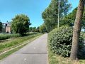
| − | + | The hash landed at the Northgodreef in Noordwijk, a mere 3.3 km from home. It may be on the bicycle path, the road itself or the grass in between. Let's go and discover! Actually quite close to [[2015-09-02_52_4|The 52,4 hash of 2015-09-02]] | |
== Participants == | == Participants == | ||
| − | + | [[User:Palmpje|Palmpje]] ([[User talk:Palmpje|talk]]) | |
| − | |||
== Plans == | == Plans == | ||
| − | + | As [[User:Palmpje|Palmpje]] would be working from home today plans were flexible. Whenever I'd have to wait for a run to finish and not have anything urgent to do I's drive over (given more time the bicycle would have been used). | |
== Expedition == | == Expedition == | ||
| − | + | A bit after 2 in the afternoon I was fed up with debugging something that should work but obviously still does not. So I took a break and drove to Noordwijk. Parking at the hash is prohibited so I parked in the residential area and had a short walk (about 150m) to the hash. First it appeared to be in the middle of some bushes, then on the road but eventually the GPSr decided it was on the edge of the bicycle path. Lucky me! | |
| − | + | Not much more adventure to be had | |
| − | |||
| − | |||
== Photos == | == Photos == | ||
| − | |||
| − | |||
| − | |||
<gallery perrow="5"> | <gallery perrow="5"> | ||
| + | Image:20220603_52_4_Proof.jpg | Right here | ||
| + | Image:20220603_52_4_Northish.jpg | Wasteland | ||
| + | Image:20220603_52_4_Eastish.jpg | That is the way home | ||
| + | Image:20220603_52_4_Soutish.jpg | Nice houses here | ||
| + | Image:20220603_52_4_Westish.jpg | To the beach! | ||
</gallery> | </gallery> | ||
== Achievements == | == Achievements == | ||
{{#vardefine:ribbonwidth|800px}} | {{#vardefine:ribbonwidth|800px}} | ||
| − | + | {{land geohash | latitude = 52 | longitude = 4 | date = 2022-06-03 | name = [[User:Palmpje|Palmpje]] }} | |
| − | + | {{Déjà vu geohash | latitude = 52 | longitude = 4 | date = 2022-06-03 | olddate = so many days | |
| − | + | | name = [[User:Palmpje|Palmpje]]}} | |
| − | |||
| − | [[ | ||
| − | |||
| − | |||
| − | |||
| − | |||
| − | |||
| − | |||
| − | |||
| − | |||
| − | |||
| − | |||
[[Category:Expeditions]] | [[Category:Expeditions]] | ||
| − | |||
[[Category:Expeditions with photos]] | [[Category:Expeditions with photos]] | ||
| − | |||
| − | |||
| − | |||
| − | |||
| − | |||
[[Category:Coordinates reached]] | [[Category:Coordinates reached]] | ||
| − | + | {{location|NL|ZH}} | |
| − | |||
| − | |||
| − | |||
| − | |||
| − | |||
| − | |||
| − | |||
| − | |||
| − | |||
| − | |||
| − | |||
| − | |||
| − | |||
| − | |||
| − | |||
| − | |||
| − | |||
Latest revision as of 19:42, 6 June 2022
| Fri 3 Jun 2022 in 52,4: 52.2445038, 4.4544887 geohashing.info google osm bing/os kml crox |
Location
The hash landed at the Northgodreef in Noordwijk, a mere 3.3 km from home. It may be on the bicycle path, the road itself or the grass in between. Let's go and discover! Actually quite close to The 52,4 hash of 2015-09-02
Participants
Plans
As Palmpje would be working from home today plans were flexible. Whenever I'd have to wait for a run to finish and not have anything urgent to do I's drive over (given more time the bicycle would have been used).
Expedition
A bit after 2 in the afternoon I was fed up with debugging something that should work but obviously still does not. So I took a break and drove to Noordwijk. Parking at the hash is prohibited so I parked in the residential area and had a short walk (about 150m) to the hash. First it appeared to be in the middle of some bushes, then on the road but eventually the GPSr decided it was on the edge of the bicycle path. Lucky me! Not much more adventure to be had
Photos
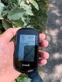
Right here
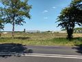
Wasteland
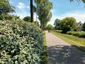
That is the way home
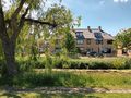
Nice houses here
To the beach!


Achievements
Palmpje earned the Land geohash achievement
|
Palmpje earned the Déjà Vu Geohash Achievement
|