Difference between revisions of "2022-06-14 52 9"
From Geohashing
(new report) |
m (Adding hours) |
||
| Line 30: | Line 30: | ||
[[Category:Expeditions with photos]] | [[Category:Expeditions with photos]] | ||
{{location|DE|NI|HM}} | {{location|DE|NI|HM}} | ||
| − | {{user categories|user=Fippe|tram=12|foot=3|train=82|inlineskates=7}} | + | {{user categories|user=Fippe|tram=12|foot=3|train=82|inlineskates=7|hours=18}} |
Latest revision as of 19:59, 11 December 2022
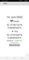
| Tue 14 Jun 2022 in 52,9: 52.1518613, 9.4848944 geohashing.info google osm bing/os kml crox |
Location
This Geohash is located between three fields in Hohnsen.
Participants
Expedition
I took the train to Bad Münder and inline-skated to the edge of the fields beyond Hachmühlen, and continued on foot.
Walking between the fields prooved difficult as there was a deep ditch in the middle, walking along parallel tractor tracks was much easier. The Geohash was in a corner of that field, near a tripoint with two others. At the tripoint, there was a tree.
After recording proof, I got back on the path, skated back to the station and took the train back to Hannover-Bismarckstraße.
Photos

Proof
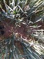
The Geohash
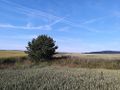
The site of the Geohash


Ribbons
Fippe earned the Land geohash achievement
|