Difference between revisions of "2022-06-19 46 -122"
Michael5000 (talk | contribs) (Created page with "{{subst:Expedition}}") |
Michael5000 (talk | contribs) (→Achievements) |
||
| (9 intermediate revisions by 2 users not shown) | |||
| Line 14: | Line 14: | ||
__NOTOC__ | __NOTOC__ | ||
== Location == | == Location == | ||
| − | + | ||
| + | On the shoulder of Camus Road, off the Winlock-Toledo exit of I-5. | ||
== Participants == | == Participants == | ||
| − | |||
| − | |||
| − | + | [[User:Michael5000|Michael5000]] | |
| − | |||
== Expedition == | == Expedition == | ||
| − | |||
| − | + | For the second weekend in a row, I found myself zipping up Interstate 5 into the State of Washington in search of a hashpoint. This time I went as far as the exit that serves the little towns of Winlock and Toledo, parked in a convenient "park and ride" lot, and changed into my running clothes. | |
| − | + | ||
| + | After [[2022-06-11 46 -123|last weekend's phone failure]], I had been excited to have my phone available for this expedition. So excited, in fact, that I made a point of hooking it up to a charger to make sure it would be ready! Not excited enough, unfortunately, to remember to reclaim it from the charger on my way out the door -- so, once again, this would be a hashpoint where I wasn't able to record either the view or the grin. | ||
| + | |||
| + | "Camus Road" is probably a misspelling of "camas" or wild onion, an extremely common placename in Oregon and Washington, but it's fun to imagine that it's rural Washington's salute to Albert Camus. Whichever. I ran about a mile down the lightly trafficked road to the hashpoint, which was just off the side of the road. There I was! Just last like week, I decided that if I didn't have a camera at the hashpoint, I'd have to take the hashpoint to a camera, so I picked up a representative hashrock and stuck it in my running belt. I continued south on Camus Road, which ducked in behind some rusty metalwork statues, if that's the word, that one sees to the east of the freeway about halfway between Tacoma and Portland. Eventually, the road followed a little river under the freeway, then I caught another road heading back north, and eventually finished the circuit of about 5 1/2 miles. So, that was pretty good exercise. | ||
| + | |||
| + | After cooling off a little, I drove over to Winlock to behold the nominal "World's Largest Egg." I was mildly charmed, but also a little underwhelmed. I don't want to let down the home team, but I think Vegreville, Alberta has them beat. | ||
| + | |||
| + | Later in the afternoon, I didn't quite make it to [[2022-06-19 45 -122]]. | ||
== Photos == | == Photos == | ||
| − | |||
| − | |||
| − | |||
<gallery perrow="5"> | <gallery perrow="5"> | ||
| + | File:2022-06-19 46 -122 a.jpg|Rock from the hashpoint, photographed after the fact. | ||
| + | File:2022-06-19 46 -122 map.jpg|The running route, including the hashpoint. | ||
</gallery> | </gallery> | ||
== Achievements == | == Achievements == | ||
{{#vardefine:ribbonwidth|800px}} | {{#vardefine:ribbonwidth|800px}} | ||
| − | |||
| − | |||
| − | |||
| − | |||
| − | |||
| − | |||
| − | |||
| − | + | *After four expeditions this year, [[Mt. St. Helens, Washington]] is now my second-most hashed graticule with 8 total expeditions, all successful. | |
| − | |||
| − | [[ | ||
| − | - | ||
| − | |||
| − | |||
| − | |||
[[Category:Expeditions]] | [[Category:Expeditions]] | ||
| − | |||
[[Category:Expeditions with photos]] | [[Category:Expeditions with photos]] | ||
| − | |||
| − | |||
| − | |||
| − | |||
| − | |||
[[Category:Coordinates reached]] | [[Category:Coordinates reached]] | ||
| − | + | {{location|US|WA|LE}} | |
| − | |||
| − | |||
| − | |||
| − | |||
| − | |||
| − | |||
| − | |||
| − | |||
| − | |||
| − | |||
| − | |||
| − | |||
| − | |||
| − | |||
| − | |||
| − | |||
| − | |||
Latest revision as of 16:23, 20 June 2022
| Sun 19 Jun 2022 in 46,-122: 46.4626064, -122.8840299 geohashing.info google osm bing/os kml crox |
Location
On the shoulder of Camus Road, off the Winlock-Toledo exit of I-5.
Participants
Expedition
For the second weekend in a row, I found myself zipping up Interstate 5 into the State of Washington in search of a hashpoint. This time I went as far as the exit that serves the little towns of Winlock and Toledo, parked in a convenient "park and ride" lot, and changed into my running clothes.
After last weekend's phone failure, I had been excited to have my phone available for this expedition. So excited, in fact, that I made a point of hooking it up to a charger to make sure it would be ready! Not excited enough, unfortunately, to remember to reclaim it from the charger on my way out the door -- so, once again, this would be a hashpoint where I wasn't able to record either the view or the grin.
"Camus Road" is probably a misspelling of "camas" or wild onion, an extremely common placename in Oregon and Washington, but it's fun to imagine that it's rural Washington's salute to Albert Camus. Whichever. I ran about a mile down the lightly trafficked road to the hashpoint, which was just off the side of the road. There I was! Just last like week, I decided that if I didn't have a camera at the hashpoint, I'd have to take the hashpoint to a camera, so I picked up a representative hashrock and stuck it in my running belt. I continued south on Camus Road, which ducked in behind some rusty metalwork statues, if that's the word, that one sees to the east of the freeway about halfway between Tacoma and Portland. Eventually, the road followed a little river under the freeway, then I caught another road heading back north, and eventually finished the circuit of about 5 1/2 miles. So, that was pretty good exercise.
After cooling off a little, I drove over to Winlock to behold the nominal "World's Largest Egg." I was mildly charmed, but also a little underwhelmed. I don't want to let down the home team, but I think Vegreville, Alberta has them beat.
Later in the afternoon, I didn't quite make it to 2022-06-19 45 -122.
Photos
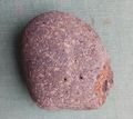
Rock from the hashpoint, photographed after the fact.
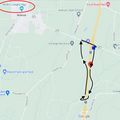
The running route, including the hashpoint.


Achievements
- After four expeditions this year, Mt. St. Helens, Washington is now my second-most hashed graticule with 8 total expeditions, all successful.