Difference between revisions of "2022-06-25 43 -79"
From Geohashing
(An expedition message sent via Geohash Droid for Android.) |
m (Location) |
||
| (5 intermediate revisions by one other user not shown) | |||
| Line 1: | Line 1: | ||
| − | + | {{meetup graticule | |
| − | |||
| − | |||
| − | |||
| − | |||
| − | |||
| − | |||
| − | |||
| − | |||
| lat=43 | | lat=43 | ||
| lon=-79 | | lon=-79 | ||
| Line 14: | Line 6: | ||
__NOTOC__ | __NOTOC__ | ||
== Location == | == Location == | ||
| − | + | On Warden Avenue south of Kingston Road in southwest Scarborough. | |
== Participants == | == Participants == | ||
| − | + | *[[User:Frogman|Frogman]] | |
| − | + | *Wyatt | |
| − | |||
| − | |||
| − | |||
== Expedition == | == Expedition == | ||
| − | + | This hashpoint is in my old stomping grounds! It's only about a five minute walk from my old apartment. I invited Wyatt to join me, and we met at about noon at Warden Station. We took the 135 to Clonmore and Warden and walked the rest of the way. After geohashing, we walked down to Neville Park loop to catch the Queen streetcars downtown to meet up with some friends. | |
| − | |||
| − | |||
| − | |||
== Photos == | == Photos == | ||
| Line 34: | Line 20: | ||
--> | --> | ||
<gallery perrow="5"> | <gallery perrow="5"> | ||
| + | |||
| + | Image:2022-06-25_43_-79_frogman_1656334870780.jpg|Waiting at Warden Station. | ||
| + | |||
| + | Image:2022-06-25_43_-79_frogman_1656334887207.jpg|We made it! | ||
| + | |||
| + | Image:2022-06-25_43_-79_frogman_1656334900192.jpg|The hashpoint. | ||
| + | |||
| + | Image:2022-06-25_43_-79_frogman_1656334971561.jpg|The intrepid expeditioners! | ||
</gallery> | </gallery> | ||
== Achievements == | == Achievements == | ||
{{#vardefine:ribbonwidth|800px}} | {{#vardefine:ribbonwidth|800px}} | ||
| − | + | {{Public transport geohash | |
| + | |||
| + | | latitude = 43 | ||
| + | | longitude = -79 | ||
| + | | date = 2022-06-25 | ||
| + | | busline = the TTC | ||
| + | | name = [[User:Frogman|Frogman]] and Wyatt | ||
| + | | image = 2022-06-25_43_-79_frogman_1656334870780.jpg | ||
| − | + | }} | |
| − | |||
| − | |||
| − | + | {{drag-along | |
| − | + | | latitude = 43 | |
| − | + | | longitude = -79 | |
| − | [[ | + | | date = 2022-06-25 |
| − | + | | partner = Wyatt | |
| + | | name = [[User:Frogman|Frogman]] | ||
| − | + | }} | |
| − | |||
[[Category:Expeditions]] | [[Category:Expeditions]] | ||
| − | |||
[[Category:Expeditions with photos]] | [[Category:Expeditions with photos]] | ||
| − | |||
| − | |||
| − | |||
| − | |||
| − | |||
[[Category:Coordinates reached]] | [[Category:Coordinates reached]] | ||
| − | + | {{location|CA|ON|TO}} | |
| − | |||
| − | |||
| − | |||
| − | |||
| − | |||
| − | |||
| − | |||
| − | |||
| − | |||
| − | |||
| − | |||
| − | |||
| − | |||
| − | |||
| − | |||
| − | |||
| − | |||
Latest revision as of 13:42, 27 June 2022
| Sat 25 Jun 2022 in 43,-79: 43.6865699, -79.2704325 geohashing.info google osm bing/os kml crox |
Location
On Warden Avenue south of Kingston Road in southwest Scarborough.
Participants
- Frogman
- Wyatt
Expedition
This hashpoint is in my old stomping grounds! It's only about a five minute walk from my old apartment. I invited Wyatt to join me, and we met at about noon at Warden Station. We took the 135 to Clonmore and Warden and walked the rest of the way. After geohashing, we walked down to Neville Park loop to catch the Queen streetcars downtown to meet up with some friends.
Photos
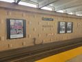
Waiting at Warden Station.
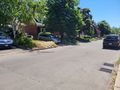
We made it!
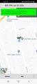
The hashpoint.
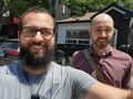
The intrepid expeditioners!


Achievements
Frogman and Wyatt earned the Public transport geohash achievement
|
Frogman earned the Drag-along achievement
|