Difference between revisions of "2022-06-28 52 10"
From Geohashing
(new report) |
m (Adding hours) |
||
| Line 31: | Line 31: | ||
[[Category:Expeditions with photos]] | [[Category:Expeditions with photos]] | ||
{{location|DE|NI|PE}} | {{location|DE|NI|PE}} | ||
| − | {{user categories|user=Fippe|tram=21|train=85|foot=5}} | + | {{user categories|user=Fippe|tram=21|train=85|foot=5|hours=19}} |
Latest revision as of 20:01, 11 December 2022
| Tue 28 Jun 2022 in 52,10: 52.4399662, 10.3046283 geohashing.info google osm bing/os kml crox |
Location
This Geohash is located on the edge of a field in Edemissen.
Participants
Expedition
I took the train to Meinersen and walked the rest of the distance. The last part was a 150m path which was unmarked on both OSM and Google. The coordinates were a step into the already harvested field.
After recording proof, I walked back to Meinersen. On the way I took a pretty terrible picture of a rabbit and a pretty decent picture of a butterfly. From Meinersen, I took the train home.
Photos

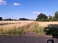
The path exists!
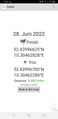
Proof
The Geohash
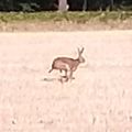
If Bigfoot was a rabbit
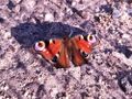
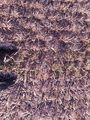
A butterfly


Ribbons
Fippe earned the Land geohash achievement
|
Fippe earned the OpenStreetMap achievement
|