Difference between revisions of "2022-07-06 47 -122"
Michael5000 (talk | contribs) (→Participants) |
Michael5000 (talk | contribs) |
||
| Line 18: | Line 18: | ||
We woke up on Tuesday morning, checked the hashpoints, and saw that there was nothing much of interest in Oregon or Washington, so we enjoyed a nice day at home taking care of chores. | We woke up on Tuesday morning, checked the hashpoints, and saw that there was nothing much of interest in Oregon or Washington, so we enjoyed a nice day at home taking care of chores. | ||
| − | + | Then, we woke up on Wednesday morning, checked the hashpoints, and saw that there was a trio stretching roughly from Seattle to the Tri Cities. That seemed a little excessive, but then it's geohashing, right? So, we had lunch in Tacoma before leaving I-5 on Washington Highway 18, then ducking south a few miles to a newish suburban neighborhood in the hills. The hashpoint was pretty much as expected, on a trail under powerlines, with a nice view off to the north into the Seattle suburbs. | |
After a short stroll, I programmed the GPS 1 degree of longitude east and off we went to [[2022-07-06 47 -121]]. | After a short stroll, I programmed the GPS 1 degree of longitude east and off we went to [[2022-07-06 47 -121]]. | ||
| Line 26: | Line 26: | ||
<gallery perrow="5"> | <gallery perrow="5"> | ||
| − | File:2022-07-06 47 -122 a.jpg| | + | File:2022-07-06 47 -122 a.jpg|The view from the hashpoint |
| − | File:2022-07-06 47 -122 b.jpg| | + | File:2022-07-06 47 -122 b.jpg|The obligatory hashpoint selfie |
| − | File:2022-07-06 47 -122 c.jpg| | + | File:2022-07-06 47 -122 c.jpg|Looking to the side towards some of the neighborhood houses |
| − | File:2022-07-06 47 -122 d.jpg| | + | File:2022-07-06 47 -122 d.jpg|We left a marker in case other geohashers needed help finding the spot |
| − | File:2022-07-06 47 -122 e.jpg| | + | File:2022-07-06 47 -122 e.jpg|Mrs.5000 explores a powerline tower |
</gallery> | </gallery> | ||
== Achievements == | == Achievements == | ||
{{#vardefine:ribbonwidth|800px}} | {{#vardefine:ribbonwidth|800px}} | ||
| − | |||
| − | |||
| − | |||
| − | |||
| − | |||
| − | |||
| − | |||
[[Category:Expeditions]] | [[Category:Expeditions]] | ||
| − | |||
[[Category:Expeditions with photos]] | [[Category:Expeditions with photos]] | ||
| − | |||
| − | |||
| − | |||
| − | |||
| − | |||
[[Category:Coordinates reached]] | [[Category:Coordinates reached]] | ||
| − | |||
| − | |||
| − | |||
| − | |||
| − | |||
| − | |||
| − | |||
| − | |||
| − | |||
| − | |||
| − | |||
| − | |||
| − | |||
| − | |||
| − | |||
| − | |||
| − | |||
| − | |||
Revision as of 00:38, 8 July 2022
| Wed 6 Jul 2022 in 47,-122: 47.2593220, -122.1964760 geohashing.info google osm bing/os kml crox |
Location
On a path in a powerline park in Auburn
Participants
Expedition
We woke up on Tuesday morning, checked the hashpoints, and saw that there was nothing much of interest in Oregon or Washington, so we enjoyed a nice day at home taking care of chores.
Then, we woke up on Wednesday morning, checked the hashpoints, and saw that there was a trio stretching roughly from Seattle to the Tri Cities. That seemed a little excessive, but then it's geohashing, right? So, we had lunch in Tacoma before leaving I-5 on Washington Highway 18, then ducking south a few miles to a newish suburban neighborhood in the hills. The hashpoint was pretty much as expected, on a trail under powerlines, with a nice view off to the north into the Seattle suburbs.
After a short stroll, I programmed the GPS 1 degree of longitude east and off we went to 2022-07-06 47 -121.
Photos
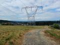
The view from the hashpoint

The obligatory hashpoint selfie
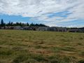
Looking to the side towards some of the neighborhood houses
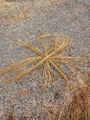
We left a marker in case other geohashers needed help finding the spot
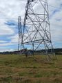
Mrs.5000 explores a powerline tower


