Difference between revisions of "2022-07-08 44 -121"
Michael5000 (talk | contribs) (→Photos) |
Michael5000 (talk | contribs) (→Achievements) |
||
| Line 41: | Line 41: | ||
== Achievements == | == Achievements == | ||
{{#vardefine:ribbonwidth|800px}} | {{#vardefine:ribbonwidth|800px}} | ||
| − | |||
| − | + | *First expedition to the Bend graticule and to Jefferson County for Mrs.5000. | |
| − | |||
| − | |||
| − | |||
| − | |||
| − | |||
| − | |||
| − | |||
| − | |||
| − | |||
| − | |||
| − | |||
| − | |||
| − | |||
[[Category:Expeditions]] | [[Category:Expeditions]] | ||
| − | |||
[[Category:Expeditions with photos]] | [[Category:Expeditions with photos]] | ||
| − | |||
| − | |||
| − | |||
| − | |||
| − | |||
[[Category:Coordinates reached]] | [[Category:Coordinates reached]] | ||
| − | |||
| − | |||
| − | |||
| − | |||
| − | |||
| − | |||
| − | |||
| − | |||
| − | |||
| − | |||
| − | |||
| − | |||
| − | |||
| − | |||
| − | |||
| − | |||
| − | |||
| − | |||
Revision as of 18:16, 10 July 2022
| Fri 8 Jul 2022 in 44,-121: 44.6115230, -121.2101686 geohashing.info google osm bing/os kml crox |
Location
Near a solar field on Elbe Road, northwest of Metolius.
Participants
Expedition
Having taken in 2022-07-08 45 -120 and 2022-07-08 44 -120 on what was by now an admittedly rather meandering route home from Pendleton, we continued west on US 26 across the Ochoco Mountains, through the tire-factory town of Prineville -- maybe we should have stopped? -- and onward to Madras, Oregon. Madras's J Street turns into Belmont Lane, which we drove out west of town through a charming high-desert agricultural landscape, down into a canyon and back out, and then to Elbe Road, which was... a dirt track. We parked the car next to a solar field -- I like to call them "sunshine farms" -- and walked half a mile through dusty heat and sagebrush to the hashpoint.
We were pretty thirsty by then, so we went to a large grocery store back in Madras, where roughly four employees were trying to keep up with the needs of approximately 100,000 customers. After surveying the scene, we went across the street to a little convenience store and bought coffee and water in what seemed in comparison like the hush of an abandoned cathedral.
So fortified, we continued south towards 2022-07-08 45 -121. We had no idea what peril awaited us, but I suppose that's always true, the human experience of time being what it is.
Photos
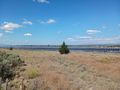
Sun farming -- this is where we parked.
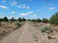
The dusty, dusty road to the hashpoint.
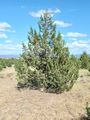
The tree that lives at the hashpoint.
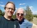
Yay, us!


Achievements
- First expedition to the Bend graticule and to Jefferson County for Mrs.5000.