Difference between revisions of "2022-07-08 47 -122"
([live picture]520 [https://openstreetmap.org/?mlat=47.63805397&mlon=-122.24128197&zoom=16 @47.6381,-122.2413]) |
|||
| Line 18: | Line 18: | ||
== Expedition == | == Expedition == | ||
| − | + | The day gets away, especially if you are headed on a camping trip on the 'morrow. | |
| + | |||
| + | An evening geohash can bring out some real beauty. We took the I-90 floating bridge eastbound from Seattle to reach Bellevue. The hashpoint was located between the parking area and the road. I did not mark with sidewalk chalk this time. | ||
| + | |||
| + | After reaching the point, I walked about and saw some of the interesting critters, including a mother duck (hen?) and 3 ducklings on the shoreline. Many pathways (and a few trails) lead to and from the water, and the intrepid hashdog walked them all. We also found a sign that was difficult to decode - the 3rd symbol from the left means don't look at the electric fan? Dunno. | ||
| + | |||
| + | Hash completed, we took the other floating bridge home again at sunset. | ||
== Tracklog == | == Tracklog == | ||
| Line 49: | Line 55: | ||
{{#vardefine:ribbonwidth|800px}} | {{#vardefine:ribbonwidth|800px}} | ||
<!-- Add any achievement ribbons you earned below, or remove this section --> | <!-- Add any achievement ribbons you earned below, or remove this section --> | ||
| − | |||
| − | |||
| − | |||
| − | |||
| − | |||
| − | |||
| − | |||
| − | |||
| − | |||
| − | |||
| − | |||
| − | |||
| − | |||
[[Category:Expeditions]] | [[Category:Expeditions]] | ||
[[Category:Expeditions with photos]] | [[Category:Expeditions with photos]] | ||
[[Category:Coordinates reached]] | [[Category:Coordinates reached]] | ||
| − | |||
| − | |||
| − | |||
| − | |||
| − | |||
| − | |||
| − | |||
| − | |||
| − | |||
| − | |||
| − | |||
{{location|US|WA|KN}} | {{location|US|WA|KN}} | ||
Latest revision as of 04:33, 9 July 2022
| Fri 8 Jul 2022 in Seattle: 47.6115230, -122.2101686 geohashing.info google osm bing/os kml crox |
Location
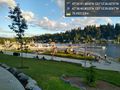
Meydenbaur Park in Bellevue, near Lake Washington
Participants
Plans
Today, but otherwise TBD
Expedition
The day gets away, especially if you are headed on a camping trip on the 'morrow.
An evening geohash can bring out some real beauty. We took the I-90 floating bridge eastbound from Seattle to reach Bellevue. The hashpoint was located between the parking area and the road. I did not mark with sidewalk chalk this time.
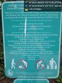
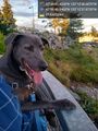
After reaching the point, I walked about and saw some of the interesting critters, including a mother duck (hen?) and 3 ducklings on the shoreline. Many pathways (and a few trails) lead to and from the water, and the intrepid hashdog walked them all. We also found a sign that was difficult to decode - the 3rd symbol from the left means don't look at the electric fan? Dunno.
Hash completed, we took the other floating bridge home again at sunset.
Tracklog
Photos
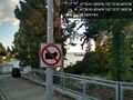
A sign of the times @47.6118,-122.2103
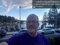
Geohasher @47.6115,-122.2102
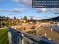
Flags @47.6108,-122.2107
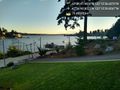
Looking west @47.6113,-122.2111
Looking south @47.6113,-122.2111
Symbols to decode @47.6120,-122.2116
Hash dog @47.6111,-122.2105


