Difference between revisions of "2022-07-11 -39 146"
([live picture]8) |
m (per Renaming Proposal) |
||
| (29 intermediate revisions by 4 users not shown) | |||
| Line 1: | Line 1: | ||
| − | |||
| − | [[ | + | [[File:61a81419-7ff9-4e40-a785-6a49e8287232.jpg|400px]] |
| − | + | {{meetup graticule | |
| − | |||
| − | |||
| − | |||
| − | |||
| − | |||
| lat=-39 | | lat=-39 | ||
| lon=146 | | lon=146 | ||
| Line 14: | Line 8: | ||
__NOTOC__ | __NOTOC__ | ||
== Location == | == Location == | ||
| − | + | On the side of a cliff near the beach in Wilson's Promontory National Park. | |
== Participants == | == Participants == | ||
| − | + | *[[User:Stevage|Stevage]] | |
| − | -- | + | *[[User:Mdixon4|Mdixon4]] |
| + | *Rhonda | ||
| + | |||
| + | == Expedition (Stevage) == | ||
| + | === Background === | ||
| + | The [[Tidal_River,_Australia|Tidal River graticule]] is a special gem. It is 98% ocean, 100% national park or other protected area, and covers the southernmost tip of mainland Australia, an area of spectacular scenery. Pristine, wild coastline, with beautiful white sand beaches, granite cliffs and stubby hills, and lots of wildlife including kangaroos, emus, possums, birds, etc. | ||
| + | |||
| + | There is only one public road, terminating at Tidal River, meaning the vast majority of the small amount of land is only accessible on foot. And there aren't very many hiking trails either. The bush in the area is often pretty dense, steep, or marshy. And did I mention it's about a 3 hour drive from Melbourne? All in all, this is not a graticule that lends itself to easy, accessible geohashes. Which is why we have had our eye on it for years. | ||
| + | |||
| + | Every few months, a point appears somewhere on land. Expeditions are mooted, but usually abandoned due to the sheer difficulty of driving down, hiking in, then finally bushbashing for possibly hours to get to the point - with only a few hours' notice. | ||
| + | |||
| + | So you can see why we were pretty excited when this geohash appeared - just inland of Leonard Bay 2 at one of the most accessible parts of the park. And on a Monday no less, giving the maximum time to plan. | ||
| + | |||
| + | [[File:2022-07-12 12_28_51-View 2022-07-11_-39_146_stevage_1657522678168.jpg - Markup Hero — Mozilla Firefo.png|300px|thumb|right|The hash was on the far side of this spur.]] | ||
| + | |||
| + | By rights, this should have been [[User:Felix Dance|Felix Dance]]'s expedition. He's been a frequent champion of this graticule, mooting possible expeditions, including one once which would have seen him knock off work, drive all the way down, hike for hours, bush bash for even more hours, hike bike, and drive...straight to work, ready to start the next day. | ||
| + | |||
| + | This adventure didn't require anything nearly so extreme. The main question was: climb up to the point from the beach, or walk along the hiking track, then descend from above? It wasn't clear whether we could get to the beach by scrambling around from Squeaky Beach, so we opted for the latter. | ||
| + | |||
| + | It was hard to find good photos of the cliff. How steep was it? How dangerous? We didn't want to get all the way there and be thwarted by a rocky cliff that was too dangerous to climb. Only one thing for it: bring abseiling gear! Rhonda brought a rope, harness and abseiling devices, and I brought my own harness. I neglected to mention that I've never actually been rock climbing outdoors, or abseiling since I was a kid. What could go wrong? | ||
| + | |||
| + | |||
| + | === Transportation === | ||
| + | I set off from home around 8:30, tramming to the city, and taking a V/Line train out to Moe, near where Matt and Rhonda live. I can't even remember the last time I took a train without my bike. It felt...weird. To pass the time, I read "What if?" by, of course, Randall Munroe. I think there's a mistake right at the end, where he suggests that the last survivor of Robert Scott's doomed Antaractic expedition was in the running for "most isolated human being", in the order of 3000 kilometres from any other human being. I ''think'' the members of his rescue crew were closer than that. | ||
| + | |||
| + | In Moe, I perused the local shops, like any normal Moe tourist, buying a pair of carrot socks for my partner, and a vanilla slice for myself. Matt and Rhonda arrived, and we made haste for the Prom... | ||
| + | |||
| + | ...until we reached Mirboo North, and (What Would Felix Do) stopped to check if the brewery was open. It wasn't. We continued... | ||
| + | |||
| + | [[File:2022-07-11 -39 146 stevage 1657522556883.jpg|thumb|300px]] | ||
| + | |||
| + | ...until we reached Meeniyan, where we were enticed by the intriguingly named "Bread & Pickles" bakery to stop for a pie. More intriguing was the sign announcing that, regretfully, there was no bread for sale. I couldn't resist asking, as I ordered my pie, whether there were any pickles for sale either. There were not. We continued... | ||
| + | |||
| + | ...wondering just what Lachie was up to. His location sharing showed he was unexpectedly launching an expedition of his own? He was a bit ahead of us in Fish Creek. Then, Tidal River. Back to Fish Creek? Suddenly he announced he had changed his mind and was in a bakery back in Melbourne after all. We continued... | ||
| + | |||
| + | ...until, just before entering the national park, I mused aloud how it was a shame that we hadn't brought any beer. The car immediately lurched to a halt, its quick witted driver having noticed instantly that we were just about to pass the last possible opportunity to buy any - the tiny village of Yanakie. Whew. We stocked up on local microbrewery, Burra, whose beer was fortunately better than their label typesetting. | ||
| + | |||
| + | Entering the National Park, we immediately saw an emu grazing to our left, and made a note to stop for photos later if it was still there. Soon after, a wallaby grazing on our right, ditto. Into the Squeaky Beach carpark! | ||
| + | |||
| + | === On foot === | ||
| + | [[File:2022-07-11 -39 146 stevage 1657522702794.jpg|thumb|300px]] | ||
| + | |||
| + | |||
| − | + | The track was incredibly well made, probably accessible by wheelchair. This made it easy to admire the scenery, a veritable showcase of Australian flora: correas, grevilleas and the iconic banksia, underneath manna gums, ti-tree and the odd acacia. We walked a short distance along an undulating ridge, looking out over the ocean, where many small islands are sprinkled about, each looking tantalisingly untouched. | |
| − | |||
| − | + | We all had a few reservations about the bush-bashing part, particularly not wanting to overly trample such important wilderness. Fortunately a semi-official trail branched off the main one and took us even closer. We gazed down at the beach - what an amazing place for a swim on a warmer day. We crunched through a few dead ti-tree branches as the distance to go ticked down under a hundred metres. We could see the little spur on which the hash lay. At first it didn't look too steep, but then we could see the lower parts looked very steep and scrambly. It was vegetated, but on very loose sand, with a sheer drop to one side of perhaps ten metres down onto the boulder-strewn beach. | |
| − | + | ||
| + | [[File:2022-07-11 -39 146 stevage 1657522748836.jpg|thumb|300px|Matt and Rhonda descend on the point, geotrash in hand.]] | ||
| − | |||
| − | |||
| − | + | After a little bit of debate, we followed the track past the top of the spur before making our way down, fighting our way through ti-tree and small scrub, inching our way from 40 metres, 30, 20, 10...5ish? The dance became very difficult, precariously manoeuvering around the edge of this steep spur, watching our footing. I recorded about 1.5m. Matt had 7, then 2, then 6...then 1.5...then 7. Rhonda got to about 2. | |
| − | |||
| − | |||
| − | |||
| − | |||
| − | + | I wasn't totally satisfied. I've been thinking about what qualifies as "success" and "reaching the geohash", and the basic question I ask is: | |
| − | + | : ''If there had been a giant pole, 1 metre in radius, magically placed at the exact coordinates, how confident are you that you could have touched the pole?'' | |
| − | + | I was maybe 50% confident. The pole might have been within my grasp, on the scrubby bit of the spur. Or it might have been just a metre further around, where a landslip had wrenched away any possible footing, leaving a sheer drop, making any attempt quite foolhardy. | |
| − | + | === Out comes the rope! === | |
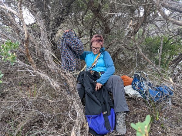
| − | + | [[File:2022-07-11 -39 146 stevage 1657522823565.jpg|thumb|300px|Rhonda gets the ropes set up.]] | |
| − | + | Rhonda was happy to practice her anchor-building technique, so set about assessing the local trees for stability, before setting a sling around two and anchoring the rope from that. I harnessed up, and with a bit more fiddling of gear, we got into a safe position where instead of abseiling, I would be tethered a fixed distance - enough to step sideways around over the abyss. | |
| − | + | Just the previous day I had been having height-related freakouts in a rock-climbing gym in much safer circumstances, but here I felt very calm, while leaning backwards over a big drop, with absolutely no way to catch myself if something happened to the rope. I inched around to where I thought the point lay, and carefully pulled out my phone - yes, 0.35m! Much better. Success! | |
| − | + | [[File:9d56da90-bf6b-49c3-8893-1f1bbdb0e20a.jpg|thumb|400px|Precariosity]] | |
| − | + | === Out === | |
| − | + | Neither Matt nor Rhonda was fussed about making their own roped journey, so we packed up and headed back. We stopped to enjoy our beers on a beautiful sandy ledge overlooking the beach, with wonderful views of the sea, the rocks, the cliffs, not a single other person anywhere. | |
| − | |||
| − | + | As we drove out, we again encountered the wallaby in exactly the same spot (on our left this time), and then the emu (on our right). Some things never change. | |
| − | |||
| − | |||
| − | |||
| − | |||
| − | |||
| − | + | [[File:2022-07-11 -39 146 stevage 1657523014972.jpg|thumb|300px|Stationary emu.]] | |
| − | + | == Tracklog == | |
| − | + | [[File:2022-07-12 12_13_16-Geohash _ Walk _ Strava — Mozilla Firefox.png|400px]] | |
| − | [[ | ||
| − | |||
| − | < | + | == Photos == |
| + | <gallery mode="packed" heights="300px"> | ||
| − | + | Image:2022-07-11_-39_146_stevage_1657522556883.jpg|They didn't sell pickles either. | |
| − | + | Image:2022-07-11_-39_146_stevage_1657522588530.jpg|Meeniyan | |
| − | -- | + | Image:2022-07-11_-39_146_stevage_1657522647582.jpg| |
| − | + | Image:2022-07-11_-39_146_stevage_1657522678168.jpg| | |
| − | + | Image:2022-07-11_-39_146_stevage_1657522702794.jpg| | |
| − | + | Image:2022-07-11_-39_146_stevage_1657522724563.jpg| | |
| − | -- | + | Image:2022-07-11_-39_146_stevage_1657522748836.jpg| |
| − | + | Image:2022-07-11_-39_146_stevage_1657522790729.jpg| | |
| − | + | Image:2022-07-11_-39_146_stevage_1657522823565.jpg| | |
| − | + | Image:2022-07-11_-39_146_stevage_1657522847978.jpg| | |
| + | Image:2022-07-11_-39_146_stevage_1657522875511.jpg | ||
| + | Image:2022-07-11_-39_146_stevage_1657522901145.jpg| | ||
| + | Image:2022-07-11_-39_146_stevage_1657522922226.jpg| | ||
| + | Image:2022-07-11_-39_146_stevage_1657522943442.jpg| | ||
| + | Image:2022-07-11_-39_146_stevage_1657522997740.jpg| | ||
| + | Image:2022-07-11_-39_146_stevage_1657522997750.jpg| | ||
| + | Image:2022-07-11_-39_146_stevage_1657523014972.jpg| | ||
| + | Image:2022-07-11_-39_146_stevage_1657523033338.jpg| | ||
| + | File:2022-07-11 -39 146 stevage 1657522875511.jpg| | ||
| + | File:9d56da90-bf6b-49c3-8893-1f1bbdb0e20a.jpg| | ||
| + | Image:2022-07-11_-39_146_mdixon4_PXL_20220711_042710845.jpg| | ||
| + | Image:2022-07-11_-39_146_mdixon4_PXL_20220711_053007938.MP-EFFECTS.jpg| | ||
| + | Image:2022-07-11_-39_146_mdixon4_PXL_20220711_054200463.MP.jpg| | ||
| + | |||
| + | </gallery> | ||
| + | == Achievements == | ||
| + | {{#vardefine:ribbonwidth|800px}} | ||
| − | -- | + | {{Graticule unlocked|latitude=-39|longitude=146|date=2022-07-11}} |
| − | |||
| − | |||
| − | |||
| − | |||
| − | |||
| − | |||
| − | |||
| − | + | {{Geotrash|latitude=-39|longitude=146|date=2022-07-11|name=Mdixon4}} | |
| − | |||
| − | |||
| − | |||
| − | |||
| − | + | [[Category:Expeditions]] | |
| + | [[Category:Coordinates reached]] | ||
| + | {{location|AU|VIC|SL}} | ||
Latest revision as of 04:43, 20 March 2024

| Mon 11 Jul 2022 in -39,146: -39.0219590, 146.2921495 geohashing.info google osm bing/os kml crox |
Location
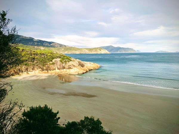
On the side of a cliff near the beach in Wilson's Promontory National Park.
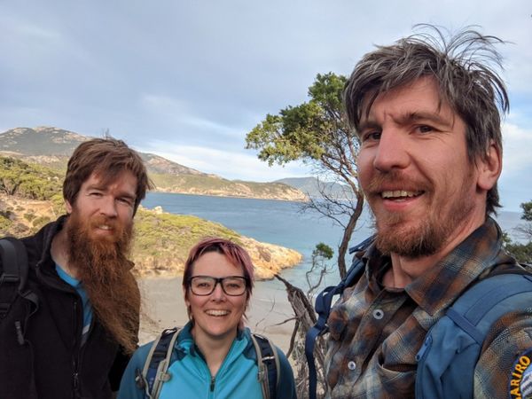
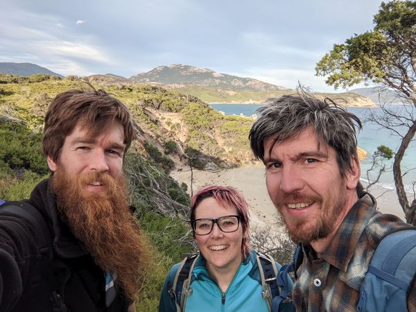
Participants
Expedition (Stevage)
Background
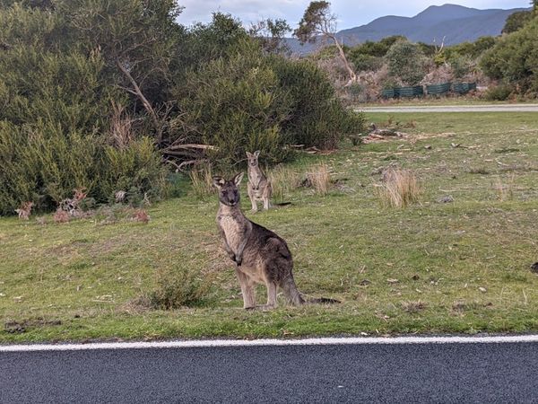
The Tidal River graticule is a special gem. It is 98% ocean, 100% national park or other protected area, and covers the southernmost tip of mainland Australia, an area of spectacular scenery. Pristine, wild coastline, with beautiful white sand beaches, granite cliffs and stubby hills, and lots of wildlife including kangaroos, emus, possums, birds, etc.
There is only one public road, terminating at Tidal River, meaning the vast majority of the small amount of land is only accessible on foot. And there aren't very many hiking trails either. The bush in the area is often pretty dense, steep, or marshy. And did I mention it's about a 3 hour drive from Melbourne? All in all, this is not a graticule that lends itself to easy, accessible geohashes. Which is why we have had our eye on it for years.
Every few months, a point appears somewhere on land. Expeditions are mooted, but usually abandoned due to the sheer difficulty of driving down, hiking in, then finally bushbashing for possibly hours to get to the point - with only a few hours' notice.
So you can see why we were pretty excited when this geohash appeared - just inland of Leonard Bay 2 at one of the most accessible parts of the park. And on a Monday no less, giving the maximum time to plan.

By rights, this should have been Felix Dance's expedition. He's been a frequent champion of this graticule, mooting possible expeditions, including one once which would have seen him knock off work, drive all the way down, hike for hours, bush bash for even more hours, hike bike, and drive...straight to work, ready to start the next day.
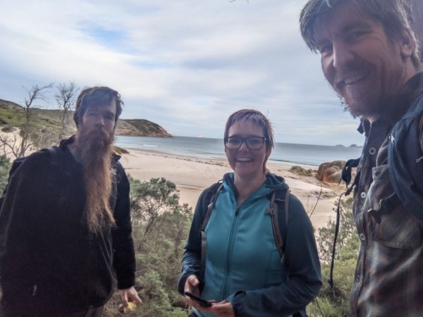
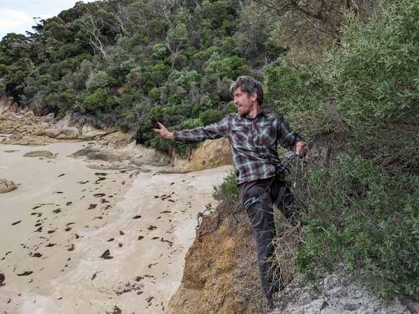
This adventure didn't require anything nearly so extreme. The main question was: climb up to the point from the beach, or walk along the hiking track, then descend from above? It wasn't clear whether we could get to the beach by scrambling around from Squeaky Beach, so we opted for the latter.
It was hard to find good photos of the cliff. How steep was it? How dangerous? We didn't want to get all the way there and be thwarted by a rocky cliff that was too dangerous to climb. Only one thing for it: bring abseiling gear! Rhonda brought a rope, harness and abseiling devices, and I brought my own harness. I neglected to mention that I've never actually been rock climbing outdoors, or abseiling since I was a kid. What could go wrong?
Transportation
I set off from home around 8:30, tramming to the city, and taking a V/Line train out to Moe, near where Matt and Rhonda live. I can't even remember the last time I took a train without my bike. It felt...weird. To pass the time, I read "What if?" by, of course, Randall Munroe. I think there's a mistake right at the end, where he suggests that the last survivor of Robert Scott's doomed Antaractic expedition was in the running for "most isolated human being", in the order of 3000 kilometres from any other human being. I think the members of his rescue crew were closer than that.
In Moe, I perused the local shops, like any normal Moe tourist, buying a pair of carrot socks for my partner, and a vanilla slice for myself. Matt and Rhonda arrived, and we made haste for the Prom...
...until we reached Mirboo North, and (What Would Felix Do) stopped to check if the brewery was open. It wasn't. We continued...

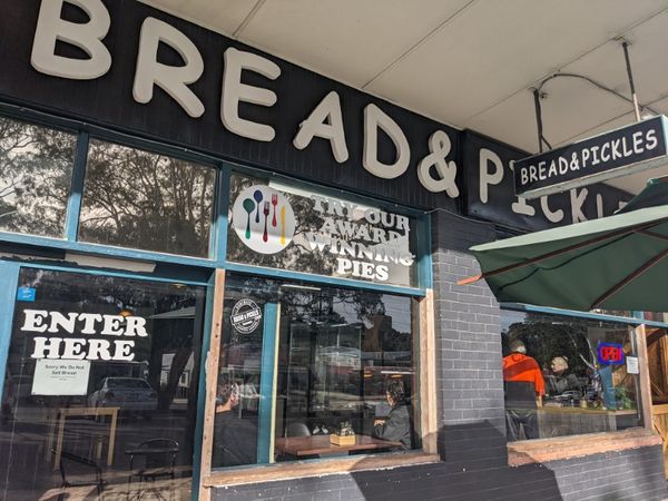
...until we reached Meeniyan, where we were enticed by the intriguingly named "Bread & Pickles" bakery to stop for a pie. More intriguing was the sign announcing that, regretfully, there was no bread for sale. I couldn't resist asking, as I ordered my pie, whether there were any pickles for sale either. There were not. We continued...
...wondering just what Lachie was up to. His location sharing showed he was unexpectedly launching an expedition of his own? He was a bit ahead of us in Fish Creek. Then, Tidal River. Back to Fish Creek? Suddenly he announced he had changed his mind and was in a bakery back in Melbourne after all. We continued...
...until, just before entering the national park, I mused aloud how it was a shame that we hadn't brought any beer. The car immediately lurched to a halt, its quick witted driver having noticed instantly that we were just about to pass the last possible opportunity to buy any - the tiny village of Yanakie. Whew. We stocked up on local microbrewery, Burra, whose beer was fortunately better than their label typesetting.
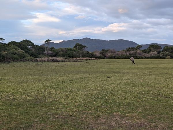
Entering the National Park, we immediately saw an emu grazing to our left, and made a note to stop for photos later if it was still there. Soon after, a wallaby grazing on our right, ditto. Into the Squeaky Beach carpark!
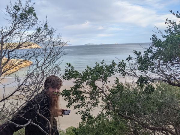
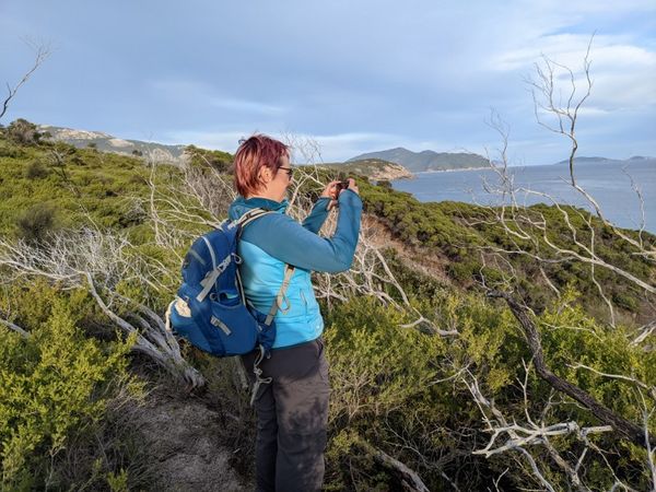
On foot

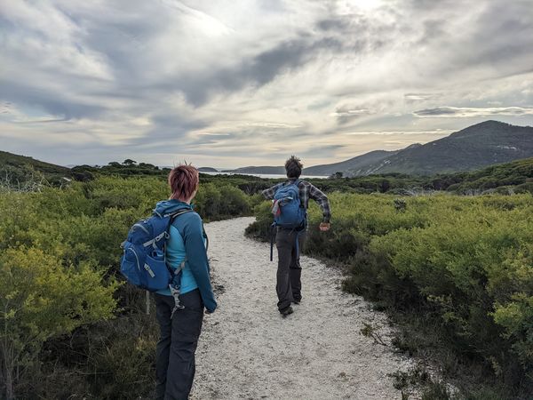
The track was incredibly well made, probably accessible by wheelchair. This made it easy to admire the scenery, a veritable showcase of Australian flora: correas, grevilleas and the iconic banksia, underneath manna gums, ti-tree and the odd acacia. We walked a short distance along an undulating ridge, looking out over the ocean, where many small islands are sprinkled about, each looking tantalisingly untouched.
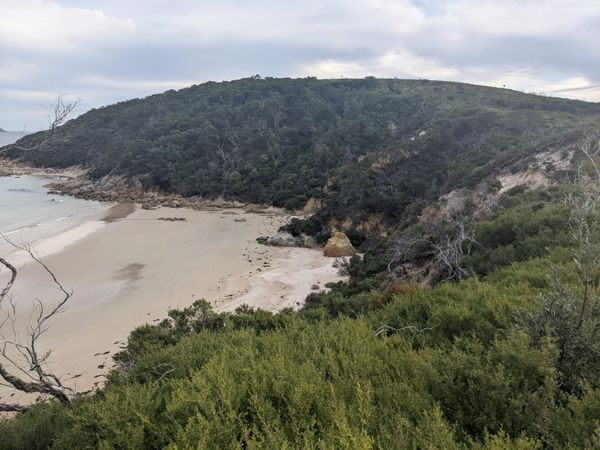
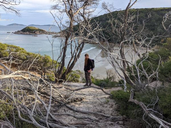
We all had a few reservations about the bush-bashing part, particularly not wanting to overly trample such important wilderness. Fortunately a semi-official trail branched off the main one and took us even closer. We gazed down at the beach - what an amazing place for a swim on a warmer day. We crunched through a few dead ti-tree branches as the distance to go ticked down under a hundred metres. We could see the little spur on which the hash lay. At first it didn't look too steep, but then we could see the lower parts looked very steep and scrambly. It was vegetated, but on very loose sand, with a sheer drop to one side of perhaps ten metres down onto the boulder-strewn beach.

After a little bit of debate, we followed the track past the top of the spur before making our way down, fighting our way through ti-tree and small scrub, inching our way from 40 metres, 30, 20, 10...5ish? The dance became very difficult, precariously manoeuvering around the edge of this steep spur, watching our footing. I recorded about 1.5m. Matt had 7, then 2, then 6...then 1.5...then 7. Rhonda got to about 2.
I wasn't totally satisfied. I've been thinking about what qualifies as "success" and "reaching the geohash", and the basic question I ask is:
- If there had been a giant pole, 1 metre in radius, magically placed at the exact coordinates, how confident are you that you could have touched the pole?
I was maybe 50% confident. The pole might have been within my grasp, on the scrubby bit of the spur. Or it might have been just a metre further around, where a landslip had wrenched away any possible footing, leaving a sheer drop, making any attempt quite foolhardy.
Out comes the rope!

Rhonda was happy to practice her anchor-building technique, so set about assessing the local trees for stability, before setting a sling around two and anchoring the rope from that. I harnessed up, and with a bit more fiddling of gear, we got into a safe position where instead of abseiling, I would be tethered a fixed distance - enough to step sideways around over the abyss.
Just the previous day I had been having height-related freakouts in a rock-climbing gym in much safer circumstances, but here I felt very calm, while leaning backwards over a big drop, with absolutely no way to catch myself if something happened to the rope. I inched around to where I thought the point lay, and carefully pulled out my phone - yes, 0.35m! Much better. Success!

Out
Neither Matt nor Rhonda was fussed about making their own roped journey, so we packed up and headed back. We stopped to enjoy our beers on a beautiful sandy ledge overlooking the beach, with wonderful views of the sea, the rocks, the cliffs, not a single other person anywhere.
As we drove out, we again encountered the wallaby in exactly the same spot (on our left this time), and then the emu (on our right). Some things never change.

Tracklog

Photos
They didn't sell pickles either.
Meeniyan


Achievements
This user earned the Graticule Unlocked Achievement
|
Mdixon4 earned the GeoTrash Geohash Achievement
|