Difference between revisions of "2022-07-14 39 -86"
Capricorn5 (talk | contribs) m (→Participants) |
m (Location) |
||
| (14 intermediate revisions by 2 users not shown) | |||
| Line 8: | Line 8: | ||
And DON'T FORGET to add your expedition and the best photo you took to the gallery on the Main Page! We'd love to read your report, but that means we first have to discover it! :) | And DON'T FORGET to add your expedition and the best photo you took to the gallery on the Main Page! We'd love to read your report, but that means we first have to discover it! :) | ||
-->{{meetup graticule | -->{{meetup graticule | ||
| − | | lat=39 | + | | lat=39 |
| − | | lon=-86 | + | | lon=-86 |
| date=2022-07-14 | | date=2022-07-14 | ||
}}<!-- edit as necessary --> | }}<!-- edit as necessary --> | ||
| − | |||
== Location == | == Location == | ||
1.8 miles northeast of the Indianapolis Motor Speedway, possibly close enough to hear it when races are underway at 100-130 decibels - the sound of 700 horsepower at 200+ miles per hour! | 1.8 miles northeast of the Indianapolis Motor Speedway, possibly close enough to hear it when races are underway at 100-130 decibels - the sound of 700 horsepower at 200+ miles per hour! | ||
== Participants == | == Participants == | ||
| − | Hope and Intrepid Husband, with ambient noise provided by Large Barking Dog | + | [[User:Capricorn5|Hope]] and Intrepid Husband, with ambient noise provided by Large Barking Dog. |
== Plans == | == Plans == | ||
| − | + | Checked the hashpoints over coffee, fully anticipating to find them in the middle of corn or soybean fields throughout the state, and was happily surprised to see that it was sited in the Eagledale, Indianapolis area. Not just in an accessible location, but a fun location - Centennial & Groff Park and Splash Pad! All evening plans and corresponding responsibilities were belayed in the service of an adventure to the hashpoint. | |
== Expedition == | == Expedition == | ||
| − | + | A not-particularly scenic trip via the Orange Construction-Coned Wonderland of 465 West expedited arrival at Speedway, Indiana, and with some pothole dodging east on 10th street and some unintentional swerving in the direction of the Mug-n-Bun Drive In's siren song, we reached Centennial & Groff Park. The only other park user was a frisbee-throwing dude and his dogs who were clearly not seeking the hashpoint but possibly wondering why I was holding my phone and doing something resembling the Rumba Box Step Dance in the street (trust me, not something you'd want to behold). Turns out, this was the trip in which I learned that the GPS on my phone teleports me randomly around once within three meters of the hashpoint. That meant that when I breathed or leaned slightly in any direction, all bets were off as to where I was in relation to the hashpoint. Intrepid Husband was a diligent and supportive traffic spotter, until we called it close enough at 4.19 meters, despite being within 0.8 meters one inhalation previously. Splash Pad was not operating and it was hot enough to scald skin on the playground equipment, so with discretion being the better part of valor in this instance we opted for dinner at the Mug-n-Bun, a Speedway tradition since 1960. | |
| − | |||
| − | |||
| − | |||
== Photos == | == Photos == | ||
| Line 33: | Line 29: | ||
--> | --> | ||
<gallery perrow="5"> | <gallery perrow="5"> | ||
| + | Image:2022_07_14_hashpoint.jpg|Semi-Elusive Hashpoint | ||
| + | Image:2022_07_14_hashproof.JPG|Hashproof | ||
| + | Image:022_07_14_Southeast.JPG |View to the Southeast and Invisible Splashpad | ||
| + | Image:022_07_14_shady geohashers.jpg|Shady Geohashers | ||
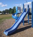
| + | Image:022_07_14_park.JPG |At the Park | ||
</gallery> | </gallery> | ||
| Line 39: | Line 40: | ||
<!-- Add any achievement ribbons you earned below, or remove this section --> | <!-- Add any achievement ribbons you earned below, or remove this section --> | ||
| − | + | __NOTOC__ | |
| − | |||
| − | |||
| − | |||
| − | |||
| − | |||
| − | |||
| − | |||
| − | |||
| − | |||
| − | |||
| − | |||
| − | |||
| − | |||
[[Category:Expeditions]] | [[Category:Expeditions]] | ||
| − | |||
[[Category:Expeditions with photos]] | [[Category:Expeditions with photos]] | ||
| − | |||
| − | |||
| − | |||
| − | |||
| − | |||
[[Category:Coordinates reached]] | [[Category:Coordinates reached]] | ||
| − | + | {{location|US|IN|MO}} | |
| − | |||
| − | |||
| − | |||
| − | |||
| − | |||
| − | |||
| − | |||
| − | |||
| − | |||
| − | |||
| − | |||
| − | |||
| − | |||
| − | |||
| − | |||
| − | |||
| − | |||
Latest revision as of 09:43, 17 July 2022
| Thu 14 Jul 2022 in 39,-86: 39.7988281, -86.2140834 geohashing.info google osm bing/os kml crox |
Location
1.8 miles northeast of the Indianapolis Motor Speedway, possibly close enough to hear it when races are underway at 100-130 decibels - the sound of 700 horsepower at 200+ miles per hour!
Participants
Hope and Intrepid Husband, with ambient noise provided by Large Barking Dog.
Plans
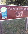
Checked the hashpoints over coffee, fully anticipating to find them in the middle of corn or soybean fields throughout the state, and was happily surprised to see that it was sited in the Eagledale, Indianapolis area. Not just in an accessible location, but a fun location - Centennial & Groff Park and Splash Pad! All evening plans and corresponding responsibilities were belayed in the service of an adventure to the hashpoint.
Expedition
A not-particularly scenic trip via the Orange Construction-Coned Wonderland of 465 West expedited arrival at Speedway, Indiana, and with some pothole dodging east on 10th street and some unintentional swerving in the direction of the Mug-n-Bun Drive In's siren song, we reached Centennial & Groff Park. The only other park user was a frisbee-throwing dude and his dogs who were clearly not seeking the hashpoint but possibly wondering why I was holding my phone and doing something resembling the Rumba Box Step Dance in the street (trust me, not something you'd want to behold). Turns out, this was the trip in which I learned that the GPS on my phone teleports me randomly around once within three meters of the hashpoint. That meant that when I breathed or leaned slightly in any direction, all bets were off as to where I was in relation to the hashpoint. Intrepid Husband was a diligent and supportive traffic spotter, until we called it close enough at 4.19 meters, despite being within 0.8 meters one inhalation previously. Splash Pad was not operating and it was hot enough to scald skin on the playground equipment, so with discretion being the better part of valor in this instance we opted for dinner at the Mug-n-Bun, a Speedway tradition since 1960.
Photos
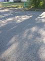
Semi-Elusive Hashpoint
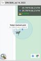
Hashproof
View to the Southeast and Invisible Splashpad
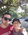
Shady Geohashers
At the Park


