Difference between revisions of "2022-07-28 48 7"
From Geohashing
m (Location) |
(→Achievements: Last man standing) |
||
| Line 41: | Line 41: | ||
| distance = 22 km | | distance = 22 km | ||
| bothways = true | | bothways = true | ||
| + | }} | ||
| + | {{Last man standing | ||
| + | | latitude = 48 | ||
| + | | longitude = 7 | ||
| + | | date = 2022-07-28 | ||
| + | | name = [[User:Baarde|Baarde]] | ||
}} | }} | ||
Latest revision as of 13:37, 26 March 2023
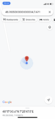
| Thu 28 Jul 2022 in 48,7: 48.2834951, 7.4298727 geohashing.info google osm bing/os kml crox |
Location
In the vineyards near Scherwiller.
Participants
Expedition
I left Sélestat in the evening and cycled to the nearby village of Scherwiller.
The coordinates were located in the vineyards. After recording proof, I continued southwards for a dozen kilometres before heading back home.
Photos
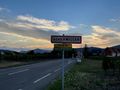
In Scherwiller
TER 831758 from Strasbourg to Sélestat
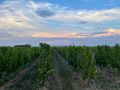
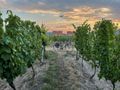
Coordinates reached
Surroundings (East)
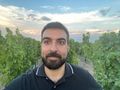
Stupid grin
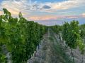
Surroundings (West)
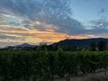
Ramstein and Ortenbourg castles in the distance


Achievements
Baarde earned the Land geohash achievement
|
Baarde earned the Bicycle geohash achievement
|
Baarde earned the Last man standing achievement
|