Difference between revisions of "2022-08-18 51 7"
Lam 'al Adie (talk | contribs) (→Plans) |
m (Location) |
||
| (7 intermediate revisions by 2 users not shown) | |||
| Line 1: | Line 1: | ||
| − | + | {{meetup graticule | |
| − | |||
| − | |||
| − | |||
| − | |||
| − | |||
| − | |||
| − | |||
| − | |||
| lat=51 | | lat=51 | ||
| lon=7 | | lon=7 | ||
| date=2022-08-18 | | date=2022-08-18 | ||
}}<!-- edit as necessary --> | }}<!-- edit as necessary --> | ||
| − | |||
== Here do be dragons! == | == Here do be dragons! == | ||
<!-- where you've surveyed the hash to be --> | <!-- where you've surveyed the hash to be --> | ||
| + | [[File:Here do be dragons!.jpg|320px|Here do be dragons]] | ||
| + | |||
| + | ==Location== | ||
Today's hashpoint was located just a few meters away from the Drachenbrücke (Dragon-Bridge) to the former mine dump [https://de.wikipedia.org/wiki/Halde_Hoheward Halde Hoheward] | Today's hashpoint was located just a few meters away from the Drachenbrücke (Dragon-Bridge) to the former mine dump [https://de.wikipedia.org/wiki/Halde_Hoheward Halde Hoheward] | ||
| Line 20: | Line 14: | ||
<!-- who attended: If you link to your wiki user name in this section, your expedition will be picked up by the various statistics generated for geohashing. You may use three tildes ~ as a shortcut to automatically insert the user signature of the account you are editing with. | <!-- who attended: If you link to your wiki user name in this section, your expedition will be picked up by the various statistics generated for geohashing. You may use three tildes ~ as a shortcut to automatically insert the user signature of the account you are editing with. | ||
--> | --> | ||
| − | It was just the two of us: me (Lam 'al Adie) and my trusted mount STEVENS. | + | It was just the two of us: me ([[User:Lam 'al Adie|Lam 'al Adie]]) and my trusted mount STEVENS. |
== Plans == | == Plans == | ||
| Line 28: | Line 22: | ||
== Expedition == | == Expedition == | ||
<!-- how it all turned out. your narrative goes here. --> | <!-- how it all turned out. your narrative goes here. --> | ||
| + | The map already said so, this will be a dangerous journey. <br> | ||
| + | I'll have to sneak my way around some of the most [https://de.wikipedia.org/wiki/Zoom_Erlebniswelt_Gelsenkirchen Fierce Creatures]. | ||
| + | Then there's the problem of crossing the [https://de.wikipedia.org/wiki/Rhein-Herne-Kanal Waters of Vessels of Steel]! | ||
| + | Only some small distance to the north and I'll have to cross the [https://de.wikipedia.org/wiki/Emscher River of Poo]. This means, I have crossed the border to the barren lands! The maze of [https://de.wikipedia.org/wiki/Resser_Mark Dead Wood] needs to be mastered before I'll reach the foot of [https://de.wikipedia.org/wiki/Halde_Hoheward Mount Doom]. <br> | ||
| + | My steed is getting more and more nervous, the air smells like molten lead. On top of Mount Doom I can see the [https://de.wikipedia.org/wiki/Halde_Hoheward#Horizontobservatorium Dragons lair]. I'll have to be careful and quiet, as I'm approaching the hashpoint.<br><br> | ||
| + | Finally I'll get there, everything's fine. Only my stallion has lost some weight. He's only Bones and wires. I need to tend him well when - if - we get back home. On my way back I even get to see the dragon. It seems to be asleep. such a majestic view. I'm glad, that I didn't get engaged into a fight.<br> | ||
| + | On my way back home I cross the grounds the now abandoned [https://de.wikipedia.org/wiki/Umspannwerk_Recklinghausen Castle Electra] and pass through the formerly prosperous but now somewhat declined city of [https://de.wikipedia.org/wiki/Herne Her-Ne].<br> | ||
| + | <br> | ||
| + | This small adventure was a great fun after a day at work. Thanks to the Internet for guiding me there. | ||
== Tracklog == | == Tracklog == | ||
<!-- if your GPS device keeps a log, you may use Template:Tracklog, post a link here, or both --> | <!-- if your GPS device keeps a log, you may use Template:Tracklog, post a link here, or both --> | ||
| + | {{tracklog|Dragons.gpx}} | ||
== Photos == | == Photos == | ||
| Line 36: | Line 40: | ||
Image:2020-##-## ## ## Alpha.jpg | Witty Comment | Image:2020-##-## ## ## Alpha.jpg | Witty Comment | ||
--> | --> | ||
| − | <gallery perrow= | + | <gallery perrow=4> |
| − | + | File:Iron Vessels.jpg|thumb|vessels of steel | |
| − | + | File:bridge crossing the waters.jpg | |
| + | File:rivers of poo.jpg|thumb|rivers of poo | ||
| + | File:Waters of pest.jpg | ||
| + | File:dragons lair on mount doom.jpg|dragons lair on mount doom | ||
| + | File:my stallion is quite haggard.jpg|STEVENS is quite haggard, i need to feed him more | ||
| + | File:Dragon1.jpg|here do be dragons (1) | ||
| + | File:Dragon2.jpg|here do be dragons (2) | ||
| + | File:hoheward.jpg | ||
| + | File:on my way back home.jpg | ||
| + | File:castle electra.jpg|Castle Electra | ||
</gallery> | </gallery> | ||
| Line 45: | Line 58: | ||
<!-- Add any achievement ribbons you earned below, or remove this section --> | <!-- Add any achievement ribbons you earned below, or remove this section --> | ||
| − | + | __NOTOC__ | |
| − | |||
| − | |||
| − | |||
| − | |||
| − | |||
| − | |||
| − | |||
| − | |||
| − | |||
| − | |||
| − | |||
| − | |||
| − | |||
[[Category:Expeditions]] | [[Category:Expeditions]] | ||
| − | |||
[[Category:Expeditions with photos]] | [[Category:Expeditions with photos]] | ||
| − | |||
| − | |||
| − | |||
| − | |||
| − | |||
[[Category:Coordinates reached]] | [[Category:Coordinates reached]] | ||
| − | + | {{location|DE|NW|RE}} | |
| − | |||
| − | |||
| − | |||
| − | |||
| − | |||
| − | |||
| − | |||
| − | |||
| − | |||
| − | |||
| − | |||
| − | |||
| − | |||
| − | |||
| − | |||
| − | |||
| − | |||
Latest revision as of 16:44, 21 August 2022
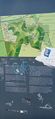
| Thu 18 Aug 2022 in 51,7: 51.5641103, 7.1742680 geohashing.info google osm bing/os kml crox |
Here do be dragons!

Location
Today's hashpoint was located just a few meters away from the Drachenbrücke (Dragon-Bridge) to the former mine dump Halde Hoheward
Participants
It was just the two of us: me (Lam 'al Adie) and my trusted mount STEVENS.
Plans
me: whoa look at that! the hashpoint is only 15 km off of my way. Gotta look into that.
Expedition
The map already said so, this will be a dangerous journey.
I'll have to sneak my way around some of the most Fierce Creatures.
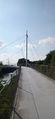
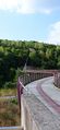
Then there's the problem of crossing the Waters of Vessels of Steel!
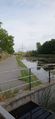
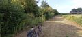
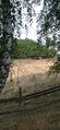
Only some small distance to the north and I'll have to cross the River of Poo. This means, I have crossed the border to the barren lands! The maze of Dead Wood needs to be mastered before I'll reach the foot of Mount Doom.
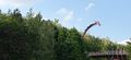
My steed is getting more and more nervous, the air smells like molten lead. On top of Mount Doom I can see the Dragons lair. I'll have to be careful and quiet, as I'm approaching the hashpoint.
Finally I'll get there, everything's fine. Only my stallion has lost some weight. He's only Bones and wires. I need to tend him well when - if - we get back home. On my way back I even get to see the dragon. It seems to be asleep. such a majestic view. I'm glad, that I didn't get engaged into a fight.
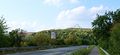
On my way back home I cross the grounds the now abandoned Castle Electra and pass through the formerly prosperous but now somewhat declined city of Her-Ne.
This small adventure was a great fun after a day at work. Thanks to the Internet for guiding me there.
Tracklog
Photos
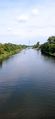
vessels of steel
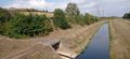
rivers of poo
dragons lair on mount doom
STEVENS is quite haggard, i need to feed him more
here do be dragons (1)
here do be dragons (2)
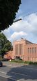
Castle Electra


