Difference between revisions of "2022-08-23 47 -122"
([live picture]Test photo [https://openstreetmap.org/?mlat=47.57030797&mlon=-122.10657397&zoom=16 @47.5703,-122.1066]) |
|||
| Line 18: | Line 18: | ||
== Expedition == | == Expedition == | ||
| − | + | Easy hash, except for the traffic. | |
| + | |||
| + | Visited Costco for gas and dogfood, cheese and butter. Nice pleasant trip south along West Sammammish drive, reaching the pullout for the trail spotted from streetview. | ||
| + | |||
| + | An easy hike up the hill, just 0.2 miles from trail head to the I-90 trail. Along the way, GPS error grew and shrank, probably due to trees. On the way back down I stopped at the hash point, and after a brief dance, got within 2m for the post. | ||
| + | |||
| + | Due to recent experience, I posted using the picture coordinates and the phone coordinates - almost no difference today. | ||
| + | |||
| + | Geohash reached, I returned to the car and fought even more traffic on the way home. Too easy not to go, though. | ||
== Tracklog == | == Tracklog == | ||
| Line 52: | Line 60: | ||
--> | --> | ||
| − | |||
| − | |||
| − | |||
[[Category:Expeditions]] | [[Category:Expeditions]] | ||
[[Category:Expeditions with photos]] | [[Category:Expeditions with photos]] | ||
[[Category:Coordinates reached]] | [[Category:Coordinates reached]] | ||
| − | |||
| − | |||
| − | |||
| − | |||
| − | |||
| − | |||
| − | |||
| − | |||
| − | |||
| − | |||
| − | |||
{{location|US|WA|KN}} | {{location|US|WA|KN}} | ||
Revision as of 05:28, 24 August 2022
| Tue 23 Aug 2022 in Seattle: 47.5702604, -122.1065778 geohashing.info google osm bing/os kml crox |
Location
Sunrise park trail, between Lake Sammammish and I-90.
Participants
Plans
Stop by after work, then take the bridge back to Seattle.
Expedition
Easy hash, except for the traffic.
Visited Costco for gas and dogfood, cheese and butter. Nice pleasant trip south along West Sammammish drive, reaching the pullout for the trail spotted from streetview.
An easy hike up the hill, just 0.2 miles from trail head to the I-90 trail. Along the way, GPS error grew and shrank, probably due to trees. On the way back down I stopped at the hash point, and after a brief dance, got within 2m for the post.
Due to recent experience, I posted using the picture coordinates and the phone coordinates - almost no difference today.
Geohash reached, I returned to the car and fought even more traffic on the way home. Too easy not to go, though.
Tracklog
Photos
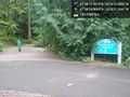
Trailhead @47.5714,-122.1059
Trail intersection @47.5699,-122.1059

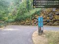
Geohasher @47.5702,-122.1066

Test photo @47.5703,-122.1066


