Difference between revisions of "2022-09-03 58 5"
From Geohashing
(→Tracklog) |
m (Categories) |
||
| (4 intermediate revisions by one other user not shown) | |||
| Line 26: | Line 26: | ||
== Expedition == | == Expedition == | ||
<!-- how it all turned out. your narrative goes here. --> | <!-- how it all turned out. your narrative goes here. --> | ||
| + | |||
| + | This was a short trip, the hash was less than 300 meters from a decent car park. As several times before, I also came this time to a cow pasture, wet and dirty. It was a bit difficult to go to point zero because it was so wet, but I managed. | ||
== Tracklog == | == Tracklog == | ||
<!-- if your GPS device keeps a log, you may use Template:Tracklog, post a link here, or both --> | <!-- if your GPS device keeps a log, you may use Template:Tracklog, post a link here, or both --> | ||
| − | |||
| − | |||
== Photos == | == Photos == | ||
| Line 39: | Line 39: | ||
Image:2022-09-03_58_5_Pica42_1662205730940.jpg|Søredalen [https://openstreetmap.org/?mlat=58.82209180&mlon=5.84305900&zoom=16 @58.8221,5.8431] | Image:2022-09-03_58_5_Pica42_1662205730940.jpg|Søredalen [https://openstreetmap.org/?mlat=58.82209180&mlon=5.84305900&zoom=16 @58.8221,5.8431] | ||
| − | Image:20220903 58 5 01.jpg|thumb|View | + | Image:20220903 58 5 01.jpg|thumb|View near the hash, on the way back to the car. |
</gallery> | </gallery> | ||
| Line 52: | Line 52: | ||
[[Category:Coordinates reached]] | [[Category:Coordinates reached]] | ||
{{location|NO|11}} | {{location|NO|11}} | ||
| − | |||
__NOTOC__ | __NOTOC__ | ||
| − | |||
| − | |||
| − | |||
| − | |||
| − | |||
| − | |||
| − | |||
| − | |||
| − | |||
| − | |||
| − | |||
| − | |||
| − | |||
| − | |||
| − | |||
| − | |||
| − | |||
| − | |||
| − | |||
| − | |||
| − | |||
| − | |||
| − | |||
| − | |||
| − | |||
| − | |||
| − | |||
| − | |||
| − | |||
| − | |||
| − | |||
| − | |||
| − | |||
| − | |||
| − | |||
| − | |||
| − | |||
| − | |||
| − | |||
| − | |||
| − | |||
Latest revision as of 18:34, 4 September 2022
| Sat 3 Sep 2022 in 58,5: 58.8220757, 5.8430522 geohashing.info google osm bing/os kml crox |
Location
Søredalen, Sandnes, Norway
Participants
Plans
Expedition
This was a short trip, the hash was less than 300 meters from a decent car park. As several times before, I also came this time to a cow pasture, wet and dirty. It was a bit difficult to go to point zero because it was so wet, but I managed.
Tracklog
Photos

Søredalen @58.8221,5.8431
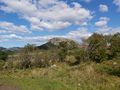
View near the hash, on the way back to the car.


Achievements
Pica42 earned the Land geohash achievement
|