Difference between revisions of "2022-09-23 47 -122"
([live picture]Hashpoint [https://openstreetmap.org/?mlat=47.63497397&mlon=-122.39289200&zoom=16 @47.6350,-122.3929]) |
|||
| Line 1: | Line 1: | ||
| − | + | {{meetup graticule | |
| − | |||
| − | |||
| − | |||
| − | |||
| − | |||
| − | |||
| − | |||
| − | |||
| lat=47 | | lat=47 | ||
| lon=-122 | | lon=-122 | ||
| date=2022-09-23 | | date=2022-09-23 | ||
| − | }} | + | | graticule_name=Seattle |
| + | | graticule_link=Seattle, Washington | ||
| + | }} | ||
| + | |||
== Location == | == Location == | ||
| − | + | Lower Magnolia, adjacent to a church | |
== Participants == | == Participants == | ||
| − | + | * [[User:Thomcat|Thomcat]] | |
| − | |||
== Plans == | == Plans == | ||
| − | + | Take plane, train, and automobile to reach geohash point | |
== Expedition == | == Expedition == | ||
| − | + | I started the expedition in Helsinki Finland, 7679 km away, presumably as the (extremely long-ranged) crow flies. An arc segment through the sphere would be an interesting route, though presumably quite warm. | |
| + | |||
| + | This is the end of a business trip, though I missed one hashpoint in Vantaa (not quite enough time in my day). Fortunately the Finn Air direct flight leaves late enough in the day that I have the Friday morning coordinates from Seattle. | ||
| + | |||
| + | The flight went well - I slept a little - and at the end I sat through an interview for Global Entry. No luggage to claim, which sped the process slightly. I then took light rail back through the city to Northgate (the current end of the line). | ||
| + | |||
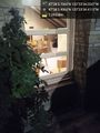
| + | From there, car to the geohashpoint, south and west of that location. Should have checked in from Northgate, alas. Drove to the proper street and spotted the church. One path led to a door in the corner of the building where I snapped the geohasher photo. Just 4m east, the other side of those large bushes, would put me on the spot. | ||
| + | |||
| + | I circled back to the sidewalk and snapped a photo of the front of the church and sign. This is my second (I think?) Holy Hash, the first one was at midnight in Spokane. | ||
| + | |||
| + | I approached the church windows and lost signal, repeating the process a few times. Triangulation and google aerial photo shows that I am on the spot; the wide GPS margin of error gives me some leeway. I did not chalk anything this time. | ||
| + | |||
| + | Having awoken for the day more than 26 hours earlier, I headed home to call it a night. | ||
== Tracklog == | == Tracklog == | ||
| Line 53: | Line 59: | ||
<!-- Add any achievement ribbons you earned below, or remove this section --> | <!-- Add any achievement ribbons you earned below, or remove this section --> | ||
| − | |||
| − | |||
| − | |||
| − | |||
| − | |||
| − | |||
| − | |||
| − | |||
| − | |||
| − | |||
| − | |||
| − | |||
| − | |||
| − | |||
| − | |||
[[Category:Expeditions]] | [[Category:Expeditions]] | ||
| − | |||
[[Category:Expeditions with photos]] | [[Category:Expeditions with photos]] | ||
| − | |||
| − | |||
| − | |||
| − | |||
| − | |||
[[Category:Coordinates reached]] | [[Category:Coordinates reached]] | ||
| − | + | {{location|US|WA|KN}} | |
| − | |||
| − | |||
| − | |||
| − | |||
| − | |||
| − | |||
| − | |||
| − | |||
| − | |||
| − | |||
| − | |||
| − | |||
| − | |||
| − | |||
| − | |||
| − | |||
| − | |||
Latest revision as of 14:36, 26 September 2022
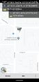
| Fri 23 Sep 2022 in Seattle: 47.6349185, -122.3928402 geohashing.info google osm bing/os kml crox |
Location
Lower Magnolia, adjacent to a church
Participants
Plans
Take plane, train, and automobile to reach geohash point
Expedition
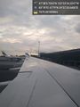
I started the expedition in Helsinki Finland, 7679 km away, presumably as the (extremely long-ranged) crow flies. An arc segment through the sphere would be an interesting route, though presumably quite warm.
This is the end of a business trip, though I missed one hashpoint in Vantaa (not quite enough time in my day). Fortunately the Finn Air direct flight leaves late enough in the day that I have the Friday morning coordinates from Seattle.
The flight went well - I slept a little - and at the end I sat through an interview for Global Entry. No luggage to claim, which sped the process slightly. I then took light rail back through the city to Northgate (the current end of the line).
From there, car to the geohashpoint, south and west of that location. Should have checked in from Northgate, alas. Drove to the proper street and spotted the church. One path led to a door in the corner of the building where I snapped the geohasher photo. Just 4m east, the other side of those large bushes, would put me on the spot.
I circled back to the sidewalk and snapped a photo of the front of the church and sign. This is my second (I think?) Holy Hash, the first one was at midnight in Spokane.
I approached the church windows and lost signal, repeating the process a few times. Triangulation and google aerial photo shows that I am on the spot; the wide GPS margin of error gives me some leeway. I did not chalk anything this time.
Having awoken for the day more than 26 hours earlier, I headed home to call it a night.
Tracklog
Photos
A long ways to travel... @60.3143,24.9599
FinnAir @60.3144,24.9599

Arrived
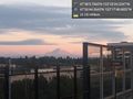
Light rail station & Mt. Rainier @47.4456,-122.2969

Geohasher @47.6349,-122.3929
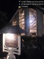
Holy ground @47.6350,-122.3929
Hashpoint @47.6350,-122.3929


