Difference between revisions of "2022-10-11 40 -77"
From Geohashing
([live picture]I don't think this is a safe space for deer. [https://openstreetmap.org/?mlat=40.05219722&mlon=-77.75936111&zoom=16 @40.0522,-77.7594]) |
m (Location) |
||
| (5 intermediate revisions by 2 users not shown) | |||
| Line 14: | Line 14: | ||
== Location == | == Location == | ||
<!-- where you've surveyed the hash to be --> | <!-- where you've surveyed the hash to be --> | ||
| + | This Geohash is located in a forest near Upper Strasburg. | ||
== Participants == | == Participants == | ||
<!-- who attended: If you link to your wiki user name in this section, your expedition will be picked up by the various statistics generated for geohashing. You may use three tildes ~ as a shortcut to automatically insert the user signature of the account you are editing with. | <!-- who attended: If you link to your wiki user name in this section, your expedition will be picked up by the various statistics generated for geohashing. You may use three tildes ~ as a shortcut to automatically insert the user signature of the account you are editing with. | ||
--> | --> | ||
| + | *[[User:OfficeLinebacker|OfficeLinebacker]] | ||
== Plans == | == Plans == | ||
<!-- what were the original plans --> | <!-- what were the original plans --> | ||
| + | *I am sorely in need of an adventure so I think I might try for this. -- [[User:OfficeLinebacker|OfficeLinebacker]] ([[User talk:OfficeLinebacker|talk]]) 10:23, 11 October 2022 (EDT) | ||
== Expedition == | == Expedition == | ||
<!-- how it all turned out. your narrative goes here. --> | <!-- how it all turned out. your narrative goes here. --> | ||
| + | *Am I logged in? -- [[User:OfficeLinebacker|OfficeLinebacker]] ([[User talk:OfficeLinebacker|talk]]) 10:24, 11 October 2022 (EDT) | ||
| − | + | *I can't tell if my posts are making it. -- [[User:OfficeLinebacker|OfficeLinebacker]] ([[User talk:OfficeLinebacker|talk]]) [https://openstreetmap.org/?mlat=40.05230180&mlon=-77.76141810&zoom=16 @40.0523,-77.7614] 12:47, 11 October 2022 (EDT) | |
| − | *I | ||
| − | |||
| − | |||
| − | |||
| − | |||
== Photos == | == Photos == | ||
| Line 40: | Line 39: | ||
Image:2022-10-11_40_-77_OfficeLinebacker_1665506322177.jpg|Here a lot of back country hiking but it turns out there are single track roads out this way and I'm able to follow some at least part of the way after parking my car. Risk plus nothing like a nice walk in the woods [https://openstreetmap.org/?mlat=40.05316389&mlon=-77.75674167&zoom=16 @40.0532,-77.7567] | Image:2022-10-11_40_-77_OfficeLinebacker_1665506322177.jpg|Here a lot of back country hiking but it turns out there are single track roads out this way and I'm able to follow some at least part of the way after parking my car. Risk plus nothing like a nice walk in the woods [https://openstreetmap.org/?mlat=40.05316389&mlon=-77.75674167&zoom=16 @40.0532,-77.7567] | ||
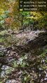
| − | Image:2022-10-11_40_- | + | Image:2022-10-11_40_-77_OfficeLinebacker_1665519384546.jpg|I don't think this is a safe space for deer. [https://openstreetmap.org/?mlat=40.05219722&mlon=-77.75936111&zoom=16 @40.0522,-77.7594] |
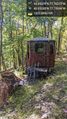
| − | Image:2022-10-11_40_- | + | Image:2022-10-11_40_-77_OfficeLinebacker_1665519384556.jpg|Not sure what to call it --- Rigatoni? [https://openstreetmap.org/?mlat=40.05278889&mlon=-77.75729722&zoom=16 @40.0528,-77.7573] |
| + | |||
| + | Image:2022-10-11_40_-77_OfficeLinebacker_1665519384568.jpg|Time to start climbing some rocks. [https://openstreetmap.org/?mlat=40.05173333&mlon=-77.76042778&zoom=16 @40.0517,-77.7604] | ||
| + | |||
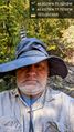
| + | Image:2022-10-11_40_-77_OfficeLinebacker_1665519384577.jpg|This is the silliest grin I could muster. I had to face the sun and it was blinding me. [https://openstreetmap.org/?mlat=40.05227500&mlon=-77.76141667&zoom=16 @40.0523,-77.7614] | ||
</gallery> | </gallery> | ||
| Line 50: | Line 53: | ||
__NOTOC__ | __NOTOC__ | ||
| − | |||
| − | |||
| − | |||
| − | |||
| − | |||
| − | |||
| − | |||
| − | |||
| − | |||
| − | |||
| − | |||
| − | |||
| − | |||
| − | |||
[[Category:Expeditions]] | [[Category:Expeditions]] | ||
| − | |||
[[Category:Expeditions with photos]] | [[Category:Expeditions with photos]] | ||
| − | |||
| − | |||
| − | |||
| − | |||
| − | |||
| − | |||
| − | |||
| − | -- | + | <!-- Guess. If this turns out to be incorrect, change the categories. --> |
[[Category:Coordinates not reached]] | [[Category:Coordinates not reached]] | ||
| − | |||
| − | |||
[[Category:Not reached - Mother Nature]] | [[Category:Not reached - Mother Nature]] | ||
| − | + | {{location|US|PA|FR}} | |
| − | |||
| − | |||
| − | |||
| − | |||
| − | |||
| − | |||
| − | |||
| − | |||
| − | |||
| − | |||
Latest revision as of 19:42, 28 November 2022
| Tue 11 Oct 2022 in 40,-77: 40.0537930, -77.7631196 geohashing.info google osm bing/os kml crox |
Location
This Geohash is located in a forest near Upper Strasburg.
Participants
Plans
- I am sorely in need of an adventure so I think I might try for this. -- OfficeLinebacker (talk) 10:23, 11 October 2022 (EDT)
Expedition
- Am I logged in? -- OfficeLinebacker (talk) 10:24, 11 October 2022 (EDT)
- I can't tell if my posts are making it. -- OfficeLinebacker (talk) @40.0523,-77.7614 12:47, 11 October 2022 (EDT)
Photos
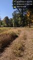
Here a lot of back country hiking but it turns out there are single track roads out this way and I'm able to follow some at least part of the way after parking my car. Risk plus nothing like a nice walk in the woods @40.0532,-77.7567
I don't think this is a safe space for deer. @40.0522,-77.7594
Not sure what to call it --- Rigatoni? @40.0528,-77.7573
Time to start climbing some rocks. @40.0517,-77.7604
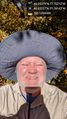
This is the silliest grin I could muster. I had to face the sun and it was blinding me. @40.0523,-77.7614


