Difference between revisions of "2022-10-26 62 29"
(Created page with "{{subst:expedition}}") |
m (Location) |
||
| (3 intermediate revisions by one other user not shown) | |||
| Line 1: | Line 1: | ||
| − | + | {{meetup graticule | |
| − | |||
| − | |||
| − | |||
| − | |||
| − | |||
| − | |||
| − | |||
| − | |||
| lat={{#explode:{{SUBPAGENAME}}| |1}} | | lat={{#explode:{{SUBPAGENAME}}| |1}} | ||
| lon={{#explode:{{SUBPAGENAME}}| |2}} | | lon={{#explode:{{SUBPAGENAME}}| |2}} | ||
| date={{#explode:{{SUBPAGENAME}}| |0}} | | date={{#explode:{{SUBPAGENAME}}| |0}} | ||
| − | }} | + | }} |
== Location == | == Location == | ||
| − | + | In a forest in Reijola, Pyhäselkä. | |
| + | |||
| + | The point on a topographic map: {{MapSiteLink | lat = 62.5344251 | lon = 29.8418547 | title = Geohash+2022-10-26+62+29}} | ||
== Participants == | == Participants == | ||
| − | + | * [[User:Kripakko|Kripakko]] | |
| − | + | ||
| + | == Expedition == | ||
| + | Finally, a hashpoint in an accessible enough place on a time when I could actually go geohashing. | ||
| + | I could cycle here after work and reach the point before sunset at 17:12 so I would be able to take pictures. | ||
| + | The weather would be pretty nice: about 3 °C, cloudy and very humid, something between mist and rain. | ||
| + | |||
| + | So I left from work after 4 pm. I made my way though the suburbs to the old highway which led to Reijola. | ||
| + | There I parked the bicycle at a bus stop and needed to walk only 80 metres to the hashpoint. | ||
| + | Surprisingly, there was a wide trail leading in the right direction, and the hashpoint happened to lie right on the trail. | ||
| + | It was nothing very special though, just some plain old dried and forested bog. | ||
| + | I took some pictures and began the journey back home. | ||
| − | + | On the way back I quickly visited a grocery store. | |
| − | + | I considered sending a [[hashcard]], but apparently the store only sold Father's Day cards (In Finland, Father's Day is in November), Christmas cards and general greeting cards, so I did not get one. | |
| + | After half past five, it started to get seriously dark, but the roads were all lit, so it was no problem. | ||
| + | I was back at home at about quarter past six. | ||
| − | + | According to the GPS receiver, the distance of the trip (from workplace to hashpoint to home) was 25.0 km, | |
| − | + | of which I cycled 24.7 km and walked 0.3 km. | |
== Tracklog == | == Tracklog == | ||
| − | + | {{Tracklog |2022-10-26 62 29 tracklog.gpx}} | |
== Photos == | == Photos == | ||
| − | |||
| − | |||
| − | |||
<gallery perrow="5"> | <gallery perrow="5"> | ||
| + | Image:2022-10-26_62_29_01-river1.jpg | View from Suvantosilta bridge, overlooking the rivershores. | ||
| + | Image:2022-10-26_62_29_02-road1.jpg | The old highway leading to Reijola. | ||
| + | Image:2022-10-26_62_29_03-road2.jpg | Where I parked the bicycle, 70 metres to go as the crow flies. | ||
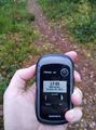
| + | Image:2022-10-26_62_29_04-gpsr1.jpg | Proof of location. | ||
| + | Image:2022-10-26_62_29_05-gpsr2.jpg | Proof of date and time. | ||
| + | Image:2022-10-26_62_29_06-selfie.jpg | Stupid Grin™ at the hashpoint. | ||
| + | Image:2022-10-26_62_29_07-forest.jpg | Another view of the forest, looking at the opposite direction from the previous picture. | ||
| + | Image:2022-10-26_62_29_08-reijola.jpg | The tiny central business district of Reijola, including a pizza-kebab restaurant, a pub, a hairdresser, a pharmacy and a veterinarian. | ||
| + | Image:2022-10-26_62_29_09-road3.jpg | Cycling back to Joensuu again. The name of the road is literally "The old highway". | ||
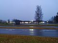
| + | Image:2022-10-26_62_29_10-river2.jpg | View from Pekkala bridge. It is getting too dark for photographing with a crappy phone camera. | ||
</gallery> | </gallery> | ||
== Achievements == | == Achievements == | ||
{{#vardefine:ribbonwidth|100%}} | {{#vardefine:ribbonwidth|100%}} | ||
| − | + | {{land geohash | name = Kripakko | latitude = 62 | longitude = 29 | date = 2022-10-26}} | |
| + | {{bicycle geohash | name = Kripakko | latitude = 62 | longitude = 29 | date = 2022-10-26 | distance = 24.7 km | bothways = true}} | ||
__NOTOC__ | __NOTOC__ | ||
| − | |||
| − | |||
| − | |||
| − | |||
| − | |||
| − | |||
| − | |||
| − | |||
| − | |||
| − | |||
| − | |||
| − | |||
| − | |||
[[Category:Expeditions]] | [[Category:Expeditions]] | ||
| − | |||
[[Category:Expeditions with photos]] | [[Category:Expeditions with photos]] | ||
| − | |||
| − | |||
| − | |||
| − | |||
| − | |||
[[Category:Coordinates reached]] | [[Category:Coordinates reached]] | ||
| − | + | {{location|FI|13}} | |
| − | |||
| − | |||
| − | |||
| − | |||
| − | |||
| − | |||
| − | |||
| − | |||
| − | |||
| − | |||
| − | |||
| − | |||
| − | |||
| − | |||
| − | |||
| − | |||
| − | |||
Latest revision as of 18:42, 26 October 2022
| Wed 26 Oct 2022 in 62,29: 62.5344251, 29.8418547 geohashing.info google osm bing/os kml crox |
Location
In a forest in Reijola, Pyhäselkä.
The point on a topographic map: [1]
Participants
Expedition
Finally, a hashpoint in an accessible enough place on a time when I could actually go geohashing. I could cycle here after work and reach the point before sunset at 17:12 so I would be able to take pictures. The weather would be pretty nice: about 3 °C, cloudy and very humid, something between mist and rain.
So I left from work after 4 pm. I made my way though the suburbs to the old highway which led to Reijola. There I parked the bicycle at a bus stop and needed to walk only 80 metres to the hashpoint. Surprisingly, there was a wide trail leading in the right direction, and the hashpoint happened to lie right on the trail. It was nothing very special though, just some plain old dried and forested bog. I took some pictures and began the journey back home.
On the way back I quickly visited a grocery store. I considered sending a hashcard, but apparently the store only sold Father's Day cards (In Finland, Father's Day is in November), Christmas cards and general greeting cards, so I did not get one. After half past five, it started to get seriously dark, but the roads were all lit, so it was no problem. I was back at home at about quarter past six.
According to the GPS receiver, the distance of the trip (from workplace to hashpoint to home) was 25.0 km, of which I cycled 24.7 km and walked 0.3 km.
Tracklog
Photos
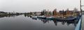
View from Suvantosilta bridge, overlooking the rivershores.
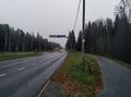
The old highway leading to Reijola.
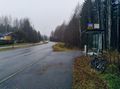
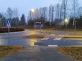
Where I parked the bicycle, 70 metres to go as the crow flies.
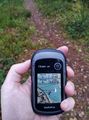
Proof of location.
Proof of date and time.
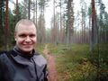
Stupid Grin™ at the hashpoint.
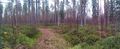
Another view of the forest, looking at the opposite direction from the previous picture.
The tiny central business district of Reijola, including a pizza-kebab restaurant, a pub, a hairdresser, a pharmacy and a veterinarian.
Cycling back to Joensuu again. The name of the road is literally "The old highway".
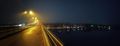
View from Pekkala bridge. It is getting too dark for photographing with a crappy phone camera.


Achievements
Kripakko earned the Land geohash achievement
|
Kripakko earned the Bicycle geohash achievement
|