Difference between revisions of "2022-11-02 62 29"
(Created page with "{{subst:expedition}}") |
m |
||
| (11 intermediate revisions by the same user not shown) | |||
| Line 1: | Line 1: | ||
| − | + | {{meetup graticule | |
| − | |||
| − | |||
| − | |||
| − | |||
| − | |||
| − | |||
| − | |||
| − | |||
| lat={{#explode:{{SUBPAGENAME}}| |1}} | | lat={{#explode:{{SUBPAGENAME}}| |1}} | ||
| lon={{#explode:{{SUBPAGENAME}}| |2}} | | lon={{#explode:{{SUBPAGENAME}}| |2}} | ||
| date={{#explode:{{SUBPAGENAME}}| |0}} | | date={{#explode:{{SUBPAGENAME}}| |0}} | ||
| − | }} | + | }} |
== Location == | == Location == | ||
| − | + | In a forest near Lehmo, Kontiolahti. | |
| + | |||
| + | The point on a topographic map: {{MapSiteLink | lat = 62.6594386 | lon = 29.8326221 | title = Geohash+2022-11-02+62+29}} | ||
== Participants == | == Participants == | ||
| − | + | * [[User:Kripakko|Kripakko]] | |
| − | |||
== Plans == | == Plans == | ||
| − | + | About 4.8 kilometres from my home, I should be able to [[Walk geohash|walk]] there along a fairly straight route. | |
| + | A [[Juggernaut achievement]] is definitely possible: I have planned a route which would have a deviation of about 1/25 from the straight line. | ||
| + | It is very physically demanding in some parts though, so I will either return along a longer easier route or catch a bus back to the town. | ||
| + | |||
| + | The weather should be no problem: it is expected to be dry and cloudy with a high temperature of 3 °C. | ||
| + | It has been raining today (2022-11-01), so some places may still be damp tomorrow. | ||
== Expedition == | == Expedition == | ||
| − | + | I took the liberty to come home from work after lunch and leave for the geohash during the afternoon, and I would work from home later in the evening once I was back. | |
| + | I wanted to have some daylight at the hashpoint, so I would need to reach it before sunset at 15:50. | ||
| + | I dressed up, took some useful stuff with me and left at about 14:15. | ||
| + | |||
| + | The Juggernaut route started from the footpath of my home street, and the straight line distance was 4778 metres. | ||
| + | I had calculated a starting point from which the maximum deviations to the left and to the right would be equal, | ||
| + | and the location would be refined later using the actual measured route. | ||
| + | Refinement moved it about 30 metres, and I took the possibility into account by starting the walk from far enough. | ||
| + | I would also have been able to complete the Juggernaut by using my home coordinates as the starting point, | ||
| + | and this point is within 1/20 of the distance (239 m) from the home coordinates, so it should be all right. | ||
| + | |||
| + | The route went through Rantakylä suburb to the jogging track, after which I had to get through a long stretch of forested bog with lots of ditches. | ||
| + | Some of the ditches were very wide and deep, up to 1.5 metres wide and deeper than the height of my boots. | ||
| + | Being easily able to do a two-metre long jump without speed, I could clear them all without getting wet. | ||
| + | Actually, I did get slightly wet because it had been raining until the forenoon and the vegetation was damp, but it was not too bad. | ||
| + | After ending up on a trail and a road, I had to go around Onkilampi pond, where I had the greatest deviation from the straight line to the left. | ||
| + | Then I followed Valimontie road for a short distance and climbed up to Lehmonharju ridge, going around a large gravel pit that I was not allowed to trespass on, | ||
| + | which in turn was the greatest deviation from the straight line to the right. | ||
| + | After making my way through the hills of Lehmonharju and another jogging track I finally arrived at Jokirannantie road, from where I just needed to follow Onnelantie road to the hashpoint. | ||
| + | The route was not particularly difficult to follow, but the terrain was very physically demanding in many places. | ||
| + | |||
| + | I arrived a the hashpoint just before four o'clock. | ||
| + | The sun had just set, but there was still enough daylight for taking a few pictures. | ||
| + | It got dark very quickly afterwards because the sky was overcast, so I got there just in time. | ||
| + | After only a quarter hour it was dark enough that I would have needed artificial light to move around in the forest. | ||
| + | I definitely did not want to return via the same route, so I walked to Nurmeksentie road which eventually led me back to the town. | ||
| + | I was back at home at about 17:15. | ||
| + | |||
| + | I wanted to do the trip as a non-intersecting loop for [[Tron achievement]]. | ||
| + | The home street was easy enough to do by returning on the opposite side of the starting footpath. | ||
| + | The shared tracklog is cut at the Juggernaut's starting point, but outside that it was trivial to walk back to the front door without crossing my previous track. | ||
| + | However, where I walked back and forth along Onnelantie road, while I walked on the right side both ways, the GPS signal jumped enough that the GPS track crossed itself. | ||
| + | I am not sure if this counts as a success, so I am going to Radio Yerevan it for now. | ||
| + | In hindsight, I should have done a larger loop in the forest to the east and returned using the road so that I would have avoided this issue altogether. | ||
| + | |||
| + | According to the GPS receiver, I walked 6.4 km to the geohash and 6.3 km back. | ||
| + | I was surprised to see that the way back was slightly shorter, but it makes sense because I had to do a lot of zig-zagging on the straighter route. | ||
| + | Also, the way there took an hour and 45 minutes, and the way back took only an hour and 15 minutes. | ||
| + | The difficult terrain definitely slowed me down, though fatigue did too towards the end. | ||
== Tracklog == | == Tracklog == | ||
| − | + | {{tracklog | 2022-11-02 62 29 tracklog.gpx}} | |
== Photos == | == Photos == | ||
| − | |||
| − | |||
| − | |||
<gallery perrow="5"> | <gallery perrow="5"> | ||
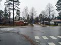
| + | Image:2022-11-02_62_29_01-road1.jpg | Rantakylänkatu street, walking to the north. | ||
| + | Image:2022-11-02_62_29_02-road2.jpg | End of Rantakylänkatu street, entering the woods. | ||
| + | Image:2022-11-02_62_29_03-bridge1.jpg | The skiing bridge over Koillisväylä road. | ||
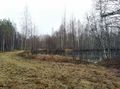
| + | Image:2022-11-02_62_29_04-pond1.jpg | One of the artificial ponds in Lehmonsuo. | ||
| + | Image:2022-11-02_62_29_05-ditch.jpg | One of the many ditches I encountered. This one is about a metre wide and who knows how deep. | ||
| + | Image:2022-11-02_62_29_06-bogflora.jpg | Some bog flora, including marsh Labrador tea (''Rhododendron tomentosum'') and bog bilberry (''Vaccinium uliginosum''). | ||
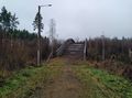
| + | Image:2022-11-02_62_29_07-bridge2.jpg | A convenient bridge built for the trail that I followed. | ||
| + | Image:2022-11-02_62_29_08-pond2.jpg | Onkilampi pond. The greatest deviation to the left was near the white rowing boat that you can see in the distance. | ||
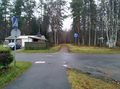
| + | Image:2022-11-02_62_29_09-road3.jpg | Valimontie road. | ||
| + | Image:2022-11-02_62_29_10-uphill.jpg | A steep uphill that I had to climb. The boulders look small in the photo, but they were surprisingly large, up to half a metre in diameter I'd say. | ||
| + | Image:2022-11-02_62_29_11-view.jpg | The view on top of the hill. You can see the pair of birches of the previous photo on the left, and here I am nearly at the level of their tops. | ||
| + | Image:2022-11-02_62_29_12-downhill.jpg | One of the downhills that I had to go down. I was moving from the photo's left to the right. | ||
| + | Image:2022-11-02_62_29_13-track1.jpg | The jogging track snaking between the hills of Lehmonharju. | ||
| + | Image:2022-11-02_62_29_14-track2.jpg | Another part of the jogging track, now in a more level forest. | ||
| + | Image:2022-11-02_62_29_15-road4.jpg | Jokirannantie road, only half a kilometre to go. There should have been power lines on this opening, but they have apparently been demolished recently. | ||
| + | Image:2022-11-02_62_29_16-gpsr1.jpg | Proof of location. | ||
| + | Image:2022-11-02_62_29_17-gpsr2.jpg | Proof of date and time. | ||
| + | Image:2022-11-02_62_29_18-selfie.jpg | Selfie at the hashpoint. | ||
| + | Image:2022-11-02_62_29_19-road5.jpg | Nurmeksentie road after dusk. | ||
| + | Image:2022-11-02_62_29_20-juggernaut.png | My route to the geohash plotted on a topographic map. The straight line distance was 4778 metres, and I deviated only at most 197 metres or 1/24.2 from it both to the left and to the right. | ||
</gallery> | </gallery> | ||
== Achievements == | == Achievements == | ||
{{#vardefine:ribbonwidth|100%}} | {{#vardefine:ribbonwidth|100%}} | ||
| − | + | ||
| + | {{land geohash | ||
| + | | latitude = 62 | ||
| + | | longitude = 29 | ||
| + | | date = 2022-11-02 | ||
| + | | name = Kripakko | ||
| + | }} | ||
| + | {{Walk geohash | ||
| + | | latitude = 62 | ||
| + | | longitude = 29 | ||
| + | | date = 2022-11-02 | ||
| + | | name = Kripakko | ||
| + | | distance = 12.7 km | ||
| + | }} | ||
| + | {{Juggernaut achievement | ||
| + | | latitude = 62 | ||
| + | | longitude = 29 | ||
| + | | date = 2022-11-02 | ||
| + | | deviation = 24 | ||
| + | | name = Kripakko | ||
| + | }} | ||
| + | {{Radio Yerevan | ||
| + | | achievement = [[Tron achievement]] | ||
| + | | detail = despite him never crossing his track, the GPS tracklog does cross itself. | ||
| + | | latitude = 62 | ||
| + | | longitude = 29 | ||
| + | | date = 2022-11-02 | ||
| + | | user = Kripakko | ||
| + | }} | ||
__NOTOC__ | __NOTOC__ | ||
| − | |||
| − | |||
| − | |||
| − | |||
| − | |||
| − | |||
| − | |||
| − | |||
| − | |||
| − | |||
| − | |||
| − | |||
| − | |||
[[Category:Expeditions]] | [[Category:Expeditions]] | ||
| − | |||
[[Category:Expeditions with photos]] | [[Category:Expeditions with photos]] | ||
| − | |||
| − | |||
| − | |||
| − | |||
| − | |||
[[Category:Coordinates reached]] | [[Category:Coordinates reached]] | ||
| − | + | {{location|FI|13}} | |
| − | |||
| − | |||
| − | |||
| − | |||
| − | |||
| − | |||
| − | |||
| − | |||
| − | |||
| − | |||
| − | |||
| − | |||
| − | |||
| − | |||
| − | |||
| − | |||
| − | |||
Revision as of 08:27, 4 November 2022
| Wed 2 Nov 2022 in 62,29: 62.6594386, 29.8326221 geohashing.info google osm bing/os kml crox |
Location
In a forest near Lehmo, Kontiolahti.
The point on a topographic map: [1]
Participants
Plans
About 4.8 kilometres from my home, I should be able to walk there along a fairly straight route. A Juggernaut achievement is definitely possible: I have planned a route which would have a deviation of about 1/25 from the straight line. It is very physically demanding in some parts though, so I will either return along a longer easier route or catch a bus back to the town.
The weather should be no problem: it is expected to be dry and cloudy with a high temperature of 3 °C. It has been raining today (2022-11-01), so some places may still be damp tomorrow.
Expedition
I took the liberty to come home from work after lunch and leave for the geohash during the afternoon, and I would work from home later in the evening once I was back. I wanted to have some daylight at the hashpoint, so I would need to reach it before sunset at 15:50. I dressed up, took some useful stuff with me and left at about 14:15.
The Juggernaut route started from the footpath of my home street, and the straight line distance was 4778 metres. I had calculated a starting point from which the maximum deviations to the left and to the right would be equal, and the location would be refined later using the actual measured route. Refinement moved it about 30 metres, and I took the possibility into account by starting the walk from far enough. I would also have been able to complete the Juggernaut by using my home coordinates as the starting point, and this point is within 1/20 of the distance (239 m) from the home coordinates, so it should be all right.
The route went through Rantakylä suburb to the jogging track, after which I had to get through a long stretch of forested bog with lots of ditches. Some of the ditches were very wide and deep, up to 1.5 metres wide and deeper than the height of my boots. Being easily able to do a two-metre long jump without speed, I could clear them all without getting wet. Actually, I did get slightly wet because it had been raining until the forenoon and the vegetation was damp, but it was not too bad. After ending up on a trail and a road, I had to go around Onkilampi pond, where I had the greatest deviation from the straight line to the left. Then I followed Valimontie road for a short distance and climbed up to Lehmonharju ridge, going around a large gravel pit that I was not allowed to trespass on, which in turn was the greatest deviation from the straight line to the right. After making my way through the hills of Lehmonharju and another jogging track I finally arrived at Jokirannantie road, from where I just needed to follow Onnelantie road to the hashpoint. The route was not particularly difficult to follow, but the terrain was very physically demanding in many places.
I arrived a the hashpoint just before four o'clock. The sun had just set, but there was still enough daylight for taking a few pictures. It got dark very quickly afterwards because the sky was overcast, so I got there just in time. After only a quarter hour it was dark enough that I would have needed artificial light to move around in the forest. I definitely did not want to return via the same route, so I walked to Nurmeksentie road which eventually led me back to the town. I was back at home at about 17:15.
I wanted to do the trip as a non-intersecting loop for Tron achievement. The home street was easy enough to do by returning on the opposite side of the starting footpath. The shared tracklog is cut at the Juggernaut's starting point, but outside that it was trivial to walk back to the front door without crossing my previous track. However, where I walked back and forth along Onnelantie road, while I walked on the right side both ways, the GPS signal jumped enough that the GPS track crossed itself. I am not sure if this counts as a success, so I am going to Radio Yerevan it for now. In hindsight, I should have done a larger loop in the forest to the east and returned using the road so that I would have avoided this issue altogether.
According to the GPS receiver, I walked 6.4 km to the geohash and 6.3 km back. I was surprised to see that the way back was slightly shorter, but it makes sense because I had to do a lot of zig-zagging on the straighter route. Also, the way there took an hour and 45 minutes, and the way back took only an hour and 15 minutes. The difficult terrain definitely slowed me down, though fatigue did too towards the end.
Tracklog
Photos
Rantakylänkatu street, walking to the north.
End of Rantakylänkatu street, entering the woods.
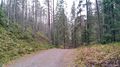
The skiing bridge over Koillisväylä road.
One of the artificial ponds in Lehmonsuo.
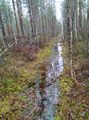
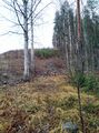
One of the many ditches I encountered. This one is about a metre wide and who knows how deep.
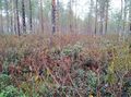
Some bog flora, including marsh Labrador tea (Rhododendron tomentosum) and bog bilberry (Vaccinium uliginosum).
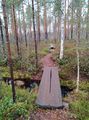
A convenient bridge built for the trail that I followed.
Onkilampi pond. The greatest deviation to the left was near the white rowing boat that you can see in the distance.
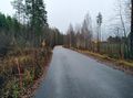
Valimontie road.
A steep uphill that I had to climb. The boulders look small in the photo, but they were surprisingly large, up to half a metre in diameter I'd say.
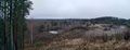
The view on top of the hill. You can see the pair of birches of the previous photo on the left, and here I am nearly at the level of their tops.
One of the downhills that I had to go down. I was moving from the photo's left to the right.
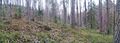
The jogging track snaking between the hills of Lehmonharju.
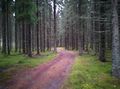
Another part of the jogging track, now in a more level forest.
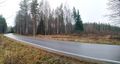
Jokirannantie road, only half a kilometre to go. There should have been power lines on this opening, but they have apparently been demolished recently.
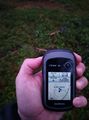
Proof of location.
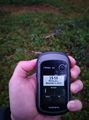
Proof of date and time.
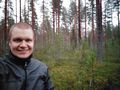
Selfie at the hashpoint.
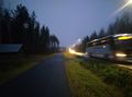
Nurmeksentie road after dusk.
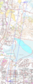
My route to the geohash plotted on a topographic map. The straight line distance was 4778 metres, and I deviated only at most 197 metres or 1/24.2 from it both to the left and to the right.


Achievements
Kripakko earned the Land geohash achievement
|
Kripakko earned the Walk geohash Achievement
|
Kripakko earned the Juggernaut achievement
|
Is it true that Kripakko earned the Tron achievement?
|