Difference between revisions of "2022-11-18 58 5"
From Geohashing
(→Participants) |
(→Achievements) |
||
| (8 intermediate revisions by 2 users not shown) | |||
| Line 20: | Line 20: | ||
--> | --> | ||
*[[User:Pica42|Pica42]] | *[[User:Pica42|Pica42]] | ||
| − | |||
| − | |||
| − | |||
== Expedition == | == Expedition == | ||
<!-- how it all turned out. your narrative goes here. --> | <!-- how it all turned out. your narrative goes here. --> | ||
| + | It was an early trip to Hundvåg, the sun had just risen and it was only 5 °C in the air. The hash was less than 100 meters from where I parked and there weren't many people out, so everything went well. | ||
== Tracklog == | == Tracklog == | ||
| Line 37: | Line 35: | ||
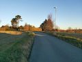
Image:2022-11-18_58_5_Pica42_1668759671322.jpg|Hundvåg [https://openstreetmap.org/?mlat=58.99870300&mlon=5.73114600&zoom=16 @58.9987,5.7311] | Image:2022-11-18_58_5_Pica42_1668759671322.jpg|Hundvåg [https://openstreetmap.org/?mlat=58.99870300&mlon=5.73114600&zoom=16 @58.9987,5.7311] | ||
| + | Image:20221118 57 5 W.jpg|thumb|View to the west from the hash. | ||
| + | Image:20221118 58 5 S.jpg|thumb|View to the south from the hash. | ||
| + | Image:20221118 58 5 E.jpg|thumb|View to the east from the hash. | ||
| + | Image:20221118 58 5 N.jpg|thumb|View to the north from the hash. | ||
</gallery> | </gallery> | ||
| Line 43: | Line 45: | ||
<!-- Add any achievement ribbons you earned below, or remove this section --> | <!-- Add any achievement ribbons you earned below, or remove this section --> | ||
| − | + | {{land geohash |name=[[User:Pica42|Pica42]] |date=2022-11-18 |latitude=58 |longitude=5 }} | |
| − | |||
| − | |||
| − | [[ | ||
| − | |||
| − | |||
| − | |||
| − | |||
| − | |||
| − | |||
| − | |||
| − | |||
| − | |||
| − | |||
| − | |||
[[Category:Expeditions]] | [[Category:Expeditions]] | ||
| − | |||
[[Category:Expeditions with photos]] | [[Category:Expeditions with photos]] | ||
| − | |||
| − | |||
| − | |||
| − | |||
| − | |||
[[Category:Coordinates reached]] | [[Category:Coordinates reached]] | ||
| + | {{location|NO|11}} | ||
| − | |||
| − | |||
| − | |||
| − | |||
| − | |||
| − | |||
| − | |||
| − | |||
| − | + | __NOTOC__ | |
| − | |||
| − | |||
| − | |||
| − | |||
| − | |||
| − | |||
Latest revision as of 12:23, 25 November 2022
| Fri 18 Nov 2022 in 58,5: 58.9987197, 5.7311135 geohashing.info google osm bing/os kml crox |
Location
Hundvåg, Stavanger, Norway
Participants
Expedition
It was an early trip to Hundvåg, the sun had just risen and it was only 5 °C in the air. The hash was less than 100 meters from where I parked and there weren't many people out, so everything went well.
Tracklog
Photos
Hundvåg @58.9987,5.7311
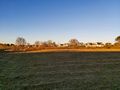
View to the west from the hash.
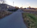
View to the south from the hash.
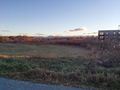
View to the east from the hash.
View to the north from the hash.


Achievements
Pica42 earned the Land geohash achievement
|