Difference between revisions of "2022-11-19 58 6"
From Geohashing
(→Location) |
(→Achievements) |
||
| (17 intermediate revisions by the same user not shown) | |||
| Line 1: | Line 1: | ||
<!-- If you did not specify these parameters in the template, please substitute appropriate values for IMAGE, LAT, LON, and DATE (YYYY-MM-DD format) | <!-- If you did not specify these parameters in the template, please substitute appropriate values for IMAGE, LAT, LON, and DATE (YYYY-MM-DD format) | ||
| − | [[Image: | + | |
| + | [[Image:20221119 104547.jpg|thumb|left]] | ||
| + | |||
Remove this section if you don't want an image at the top (left) of your report. You should remove the "Image:" or "File:" | Remove this section if you don't want an image at the top (left) of your report. You should remove the "Image:" or "File:" | ||
| Line 12: | Line 14: | ||
| date=2022-11-19 | | date=2022-11-19 | ||
}}<!-- edit as necessary --> | }}<!-- edit as necessary --> | ||
| + | [[Image:20221119 104547.jpg|thumb|left]] | ||
== Location == | == Location == | ||
<!-- where you've surveyed the hash to be --> | <!-- where you've surveyed the hash to be --> | ||
| Line 19: | Line 22: | ||
<!-- who attended: If you link to your wiki user name in this section, your expedition will be picked up by the various statistics generated for geohashing. You may use three tildes ~ as a shortcut to automatically insert the user signature of the account you are editing with. | <!-- who attended: If you link to your wiki user name in this section, your expedition will be picked up by the various statistics generated for geohashing. You may use three tildes ~ as a shortcut to automatically insert the user signature of the account you are editing with. | ||
--> | --> | ||
| + | *[[User:Pica42|Pica42]] | ||
== Plans == | == Plans == | ||
| Line 25: | Line 29: | ||
== Expedition == | == Expedition == | ||
<!-- how it all turned out. your narrative goes here. --> | <!-- how it all turned out. your narrative goes here. --> | ||
| + | |||
| + | Today I took another morning trip, this time to Egersund. It was easy to find the hash, even though it was a bit difficult terrain with a lot of junipers and some trees. | ||
== Tracklog == | == Tracklog == | ||
<!-- if your GPS device keeps a log, you may use Template:Tracklog, post a link here, or both --> | <!-- if your GPS device keeps a log, you may use Template:Tracklog, post a link here, or both --> | ||
| + | |||
| + | {{tracklog |Activity 10001183708.gpx}} | ||
== Photos == | == Photos == | ||
| Line 34: | Line 42: | ||
--> | --> | ||
<gallery perrow="5"> | <gallery perrow="5"> | ||
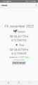
| + | Image:Screenshot 20221119-104306 Geohash Droid.jpg|thumb|Sletteidveien | ||
| + | Image:2022-11-19_58_6_Pica42_1668851994721.jpg|Bakkebø | ||
| + | Image:20221119 58 6 N.jpg|thumb|View to the north. | ||
| + | Image:20221119 58 6 SW.jpg|thumb|View to the southwest. | ||
| + | |||
| − | |||
</gallery> | </gallery> | ||
| Line 42: | Line 54: | ||
<!-- Add any achievement ribbons you earned below, or remove this section --> | <!-- Add any achievement ribbons you earned below, or remove this section --> | ||
| − | + | {{land geohash |name=[[User:Pica42|Pica42]] |date=2022-11-19 |latitude=58 |longitude=6 }} | |
| − | |||
| − | |||
| − | [[ | ||
| − | |||
| − | |||
| − | |||
| − | |||
| − | |||
| − | |||
| − | |||
| − | |||
| − | |||
| − | |||
| − | |||
[[Category:Expeditions]] | [[Category:Expeditions]] | ||
| − | |||
[[Category:Expeditions with photos]] | [[Category:Expeditions with photos]] | ||
| − | |||
| − | |||
| − | |||
| − | |||
| − | |||
[[Category:Coordinates reached]] | [[Category:Coordinates reached]] | ||
| + | {{location|NO|11}} | ||
| + | |||
| − | |||
| − | |||
| − | |||
| − | |||
| − | |||
| − | |||
| − | |||
| − | |||
| − | |||
| − | |||
| − | |||
| − | |||
| − | |||
| − | + | __NOTOC__ | |
Latest revision as of 10:02, 20 November 2022
| Sat 19 Nov 2022 in 58,6: 58.4739625, 6.0623131 geohashing.info google osm bing/os kml crox |

Location
Sletteidveien, Egersund, Norway
Participants
Plans
Expedition
Today I took another morning trip, this time to Egersund. It was easy to find the hash, even though it was a bit difficult terrain with a lot of junipers and some trees.
Tracklog
Photos
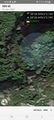
Sletteidveien
Bakkebø
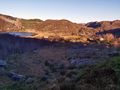
View to the north.
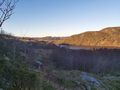
View to the southwest.


Achievements
Pica42 earned the Land geohash achievement
|