Difference between revisions of "2022-11-23 39 -108"
From Geohashing
Michael5000 (talk | contribs) (→Location) |
Michael5000 (talk | contribs) |
||
| Line 1: | Line 1: | ||
| − | + | {{meetup graticule | |
| − | |||
| − | |||
| − | |||
| − | |||
| − | |||
| − | |||
| − | |||
| − | |||
| lat={{#explode:{{SUBPAGENAME}}| |1}} | | lat={{#explode:{{SUBPAGENAME}}| |1}} | ||
| lon={{#explode:{{SUBPAGENAME}}| |2}} | | lon={{#explode:{{SUBPAGENAME}}| |2}} | ||
| Line 17: | Line 9: | ||
== Participants == | == Participants == | ||
| − | |||
| − | |||
| − | + | *[[user:Michael5000|Michael5000]] | |
| − | |||
== Expedition == | == Expedition == | ||
| − | |||
| − | + | This one was easily reached from the in-law's house. Sent out on a grocery run, I went to the City Market on the south end of town instead of the City Market on the north end of town, and swung by this hashpoint a few miles a way. It was on the right-of-way of a tiny little irrigation ditch through a residential neighborhood; I parked a few blocks away and took a short walk through. | |
| − | + | ||
== Photos == | == Photos == | ||
| − | + | ||
| − | |||
| − | |||
<gallery perrow="5"> | <gallery perrow="5"> | ||
| + | File:39 -108 2022-11-23 5.jpg|Base camp -- the in-laws' neighborhood | ||
| + | File:39 -108 2022-11-23 2.jpg|The general neighborhood | ||
| + | File:39 -108 2022-11-23 3.jpg|The hashpoint is over yonder by the little canal | ||
| + | File:39 -108 2022-11-23 4.jpg|A striking tree near the hashpoint | ||
| + | File:39 -108 2022-11-23 1.jpg|Behold, I made it! | ||
</gallery> | </gallery> | ||
| Line 41: | Line 32: | ||
__NOTOC__ | __NOTOC__ | ||
| − | |||
| − | |||
| − | |||
| − | |||
| − | |||
| − | |||
| − | |||
| − | |||
| − | |||
| − | |||
| − | |||
| − | |||
| − | |||
| − | |||
[[Category:Expeditions]] | [[Category:Expeditions]] | ||
| − | |||
[[Category:Expeditions with photos]] | [[Category:Expeditions with photos]] | ||
| − | |||
| − | |||
| − | |||
| − | |||
| − | |||
[[Category:Coordinates reached]] | [[Category:Coordinates reached]] | ||
| − | |||
| − | |||
| − | |||
| − | |||
| − | |||
| − | |||
| − | |||
| − | |||
| − | |||
| − | |||
| − | |||
| − | |||
| − | |||
| − | |||
| − | |||
| − | |||
| − | |||
| − | |||
Revision as of 20:31, 23 November 2022
| Wed 23 Nov 2022 in 39,-108: 39.0387431, -108.5532066 geohashing.info google osm bing/os kml crox |
Location
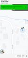
By a little canal on the south end of Grand Junction.
Participants
Expedition
This one was easily reached from the in-law's house. Sent out on a grocery run, I went to the City Market on the south end of town instead of the City Market on the north end of town, and swung by this hashpoint a few miles a way. It was on the right-of-way of a tiny little irrigation ditch through a residential neighborhood; I parked a few blocks away and took a short walk through.
Photos
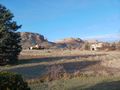
Base camp -- the in-laws' neighborhood
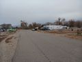
The general neighborhood
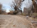
The hashpoint is over yonder by the little canal
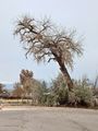
A striking tree near the hashpoint
Behold, I made it!


