Difference between revisions of "2022-11-24 58 5"
From Geohashing
(→Achievements) |
(→Achievements) |
||
| (3 intermediate revisions by the same user not shown) | |||
| Line 26: | Line 26: | ||
== Expedition == | == Expedition == | ||
<!-- how it all turned out. your narrative goes here. --> | <!-- how it all turned out. your narrative goes here. --> | ||
| + | This was the first hash I have found after sunset. I was going to a course in Stavanger, so it was a good idea to find the hash on the way to the course. | ||
== Tracklog == | == Tracklog == | ||
| Line 36: | Line 37: | ||
<gallery perrow="5"> | <gallery perrow="5"> | ||
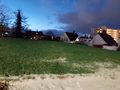
| − | Image:2022-11-24_58_5_Pica42_1669306195715.jpg| | + | Image:2022-11-24_58_5_Pica42_1669306195715.jpg|Storhaug [https://openstreetmap.org/?mlat=58.96896400&mlon=5.74267420&zoom=16 @58.9690,5.7427] |
Image:20221124 58 5 SW.jpg|thumb|View to the southwest. | Image:20221124 58 5 SW.jpg|thumb|View to the southwest. | ||
Image:20221124 58 5 E.jpg|thumb|View to the east. | Image:20221124 58 5 E.jpg|thumb|View to the east. | ||
| Line 53: | Line 54: | ||
{{location|NO|11}} | {{location|NO|11}} | ||
| − | + | {{Last man standing | |
| + | | latitude = 58 | ||
| + | | longitude = 5 | ||
| + | | date = 2022-11-24 | ||
| + | | gender = man | ||
| + | | name = [[User:Pica42|Pica42]] | ||
| + | }} | ||
__NOTOC__ | __NOTOC__ | ||
| − | |||
| − | |||
| − | |||
| − | |||
| − | |||
| − | |||
| − | |||
| − | |||
| − | |||
| − | |||
| − | |||
| − | |||
| − | |||
| − | |||
| − | |||
| − | |||
| − | |||
| − | |||
| − | |||
| − | |||
| − | |||
| − | |||
| − | |||
| − | |||
| − | |||
| − | |||
| − | |||
| − | |||
| − | |||
| − | |||
| − | |||
| − | |||
| − | |||
| − | |||
| − | |||
| − | |||
| − | |||
| − | |||
| − | |||
| − | |||
| − | |||
Latest revision as of 10:17, 28 November 2022
| Thu 24 Nov 2022 in 58,5: 58.9689553, 5.7427227 geohashing.info google osm bing/os kml crox |
Location
Storhaug, Stavanger, Norway
Participants
Plans
Expedition
This was the first hash I have found after sunset. I was going to a course in Stavanger, so it was a good idea to find the hash on the way to the course.
Tracklog
Photos
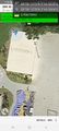
Storhaug @58.9690,5.7427
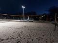
View to the southwest.
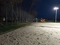
View to the east.
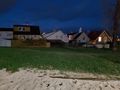
View to the north.
View to the west.


Achievements
Pica42 earned the Land geohash achievement
|
Pica42 earned the Last man standing achievement
|