Difference between revisions of "2022-12-06 47 -122"
([live picture]Near [https://openstreetmap.org/?mlat=47.67578440&mlon=-122.28876650&zoom=16 @47.6758,-122.2888]) |
Coyotebush (talk | contribs) |
||
| (6 intermediate revisions by 2 users not shown) | |||
| Line 1: | Line 1: | ||
| − | + | {{meetup graticule | |
| − | + | | lat=47 | |
| − | + | | lon=-122 | |
| − | + | | date=2022-12-06 | |
| − | + | | graticule_name=Seattle | |
| − | + | | graticule_link=Seattle, Washington | |
| − | + | }} | |
| − | |||
| − | |||
| − | | lat= | ||
| − | | lon= | ||
| − | | date= | ||
| − | }} | ||
== Location == | == Location == | ||
<!-- where you've surveyed the hash to be --> | <!-- where you've surveyed the hash to be --> | ||
| Line 17: | Line 11: | ||
== Participants == | == Participants == | ||
| − | |||
| − | |||
* [[User:Coyotebush|Coyotebush]] ([[User talk:Coyotebush|talk]]) | * [[User:Coyotebush|Coyotebush]] ([[User talk:Coyotebush|talk]]) | ||
| + | * [[User:Thomcat|Thomcat]] | ||
== Plans == | == Plans == | ||
| − | + | * Thomcat: Car. Stop by on the way to work. | |
| − | Bike. Time TBD. | + | * Coyotebush: Bike. Time TBD. |
== Expedition == | == Expedition == | ||
| − | + | === Thomcat === | |
| + | Seeing this was easier to achieve than inside a high school, I drove slightly out of my way to visit on the way to work. | ||
| + | |||
| + | Have driven on 65th many times to reach the baseball field in Magnuson Park. A little further east of here is the Wishing Meter, documented on a previous expedition. | ||
| + | |||
| + | Arriving at the site, phone GPS was not doing a good job of resolving. I walked up the alley a bit and waved the device in the air which didn't work either. **sigh** I did lean into the bush at the spot (per overhead) for the geohasher picture. The house was occupied and, being early in the morning, I did not wander into the yard for a different angle, although I did stand in the driveway at one point to try and get a better signal. | ||
| + | |||
| + | Calling it a success, I headed a little further east to a local market, hoping for a pastry, then headed off to work. | ||
| + | |||
| + | === coyotebush === | ||
| + | Apparently Thomcat was already en route by the time I woke up and created this expedition page. | ||
| + | |||
| + | I bike to this neighborhood a couple times a week - steep hills traveling east/west, or an easy climb from the Burke-Gilman Trail to the south. | ||
| + | |||
| + | Headed over around lunchtime and went right to the point. Seems like I got better GPS readings, and I just stayed on the sidewalk (which the bush indeed encroaches on). | ||
| + | |||
| + | Needed lunch and some groceries, so I too continued to the PCC before returning home. | ||
| − | |||
| − | |||
== Photos == | == Photos == | ||
| Line 38: | Line 45: | ||
Image:2022-12-06_47_-122_thomcat_1670344704829.jpg|Near [https://openstreetmap.org/?mlat=47.67578440&mlon=-122.28876650&zoom=16 @47.6758,-122.2888] | Image:2022-12-06_47_-122_thomcat_1670344704829.jpg|Near [https://openstreetmap.org/?mlat=47.67578440&mlon=-122.28876650&zoom=16 @47.6758,-122.2888] | ||
| + | |||
| + | Image:2022-12-06_47_-122_thomcat_1670344763499.jpg|Geohasher [https://openstreetmap.org/?mlat=47.67581000&mlon=-122.28886550&zoom=16 @47.6758,-122.2889] | ||
| + | |||
| + | Image:2022-12-06_47_-122_thomcat_1670344821768.jpg|Facing east [https://openstreetmap.org/?mlat=47.67580080&mlon=-122.28879240&zoom=16 @47.6758,-122.2888] | ||
| + | |||
| + | Image:2022-12-06_47_-122_thomcat_1670344946646.jpg|Nearby market [https://openstreetmap.org/?mlat=47.67596500&mlon=-122.28485440&zoom=16 @47.6760,-122.2849] | ||
| + | |||
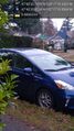
| + | Image:2022-12-06_47_-122_coyotebush_1670357915107.jpg|Second visitor [https://openstreetmap.org/?mlat=47.67575556&mlon=-122.28871389&zoom=16 @47.6758,-122.2887] | ||
| + | |||
| + | Image:2022-12-06_47_-122_coyotebush_1670362945999.jpg|closest screenshot | ||
</gallery> | </gallery> | ||
| Line 43: | Line 60: | ||
{{#vardefine:ribbonwidth|100%}} | {{#vardefine:ribbonwidth|100%}} | ||
<!-- Add any achievement ribbons you earned below, or remove this section --> | <!-- Add any achievement ribbons you earned below, or remove this section --> | ||
| + | {{bicycle geohash | ||
| + | |||
| + | | latitude = 47 | ||
| + | | longitude = -122 | ||
| + | | date = 2022-12-06 | ||
| + | | name = coyotebush | ||
| + | }} | ||
__NOTOC__ | __NOTOC__ | ||
| − | |||
| − | |||
| − | |||
| − | |||
| − | |||
| − | |||
| − | |||
| − | |||
| − | |||
| − | |||
| − | |||
| − | |||
| − | |||
| − | |||
[[Category:Expeditions]] | [[Category:Expeditions]] | ||
| − | |||
[[Category:Expeditions with photos]] | [[Category:Expeditions with photos]] | ||
| − | |||
| − | |||
| − | |||
| − | |||
| − | |||
[[Category:Coordinates reached]] | [[Category:Coordinates reached]] | ||
| − | + | {{location|US|WA|KN}} | |
| − | |||
| − | |||
| − | |||
| − | |||
| − | |||
| − | |||
| − | |||
| − | |||
| − | |||
| − | |||
| − | |||
| − | |||
| − | |||
| − | |||
| − | |||
| − | |||
| − | |||
Latest revision as of 04:52, 8 December 2022
| Tue 6 Dec 2022 in Seattle: 47.6757061, -122.2887321 geohashing.info google osm bing/os kml crox |
Location
South side of NE 65th St, between 36th and 37th Aves NE. Looks to be right on the (possibly overgrown) sidewalk.
Participants
Plans
- Thomcat: Car. Stop by on the way to work.
- Coyotebush: Bike. Time TBD.
Expedition
Thomcat
Seeing this was easier to achieve than inside a high school, I drove slightly out of my way to visit on the way to work.
Have driven on 65th many times to reach the baseball field in Magnuson Park. A little further east of here is the Wishing Meter, documented on a previous expedition.
Arriving at the site, phone GPS was not doing a good job of resolving. I walked up the alley a bit and waved the device in the air which didn't work either. **sigh** I did lean into the bush at the spot (per overhead) for the geohasher picture. The house was occupied and, being early in the morning, I did not wander into the yard for a different angle, although I did stand in the driveway at one point to try and get a better signal.
Calling it a success, I headed a little further east to a local market, hoping for a pastry, then headed off to work.
coyotebush
Apparently Thomcat was already en route by the time I woke up and created this expedition page.
I bike to this neighborhood a couple times a week - steep hills traveling east/west, or an easy climb from the Burke-Gilman Trail to the south.
Headed over around lunchtime and went right to the point. Seems like I got better GPS readings, and I just stayed on the sidewalk (which the bush indeed encroaches on).
Needed lunch and some groceries, so I too continued to the PCC before returning home.
Photos
Near @47.6758,-122.2888
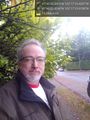
Geohasher @47.6758,-122.2889
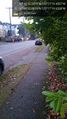
Facing east @47.6758,-122.2888
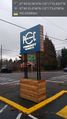
Nearby market @47.6760,-122.2849
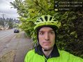
Second visitor @47.6758,-122.2887
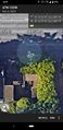
closest screenshot


Achievements
coyotebush earned the Bicycle geohash achievement
|