2022-12-30 47 -122
| Fri 30 Dec 2022 in Seattle: 47.6275231, -122.1238130 geohashing.info google osm bing/os kml crox |
Location
Sidewalk of NE 19th Place in the northeast Bellevue.
Participants
Plans
Visit mid-day, also explore trail one street west leading to Interlake HS baseball field.
Expedition
A little end-of-the-year geohash sounds like a pretty cool thing, and this one was more about exploring than meetups.
I've worked more than a few baseball games as the nearby field, and looking at the open streetmap, I see a path leading to the complex that I didn't know was there. It's a block away, but a worthy counterpoint to visiting the street hash - which is where I started.
I didn't park on the spot because I didn't want to block any driveways, and it seems like plenty of people were home on a Friday mid-day - perhaps the holiday observed? Coordinates drifted a bit, and I got a me photo fairly close. I'm certain I walked over the spot, pacing back and forth. I'm also certain any neighbors who watched me think I am with the water or sewer service, pacing from access cover to access cover.
That done, I looped around the block for said passageway. Quite narrow, and in hindsight, I now know why all the streets were marked with "no parking 7am to 3pm without resident permit" - it's excellent access to the school. I snapped a few photos, but decided not to walk to the field itself. It's been raining a lot recently, and the area around this field is a muddy mess in the rain - I've worked under those conditions.
Geohash done, exploration done, I returned across the floating bridge (paying the toll) and my final stop was a Spud, reopened now and a great post-hash nutrition point.
Tracklog
Photos
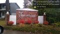
Fairmont @47.6255,-122.1242
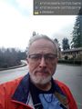
Geohasher @47.6275,-122.1238
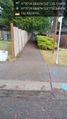
Pass through @47.6275,-122.1257

Pass through @47.6275,-122.1257
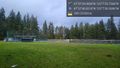
High School fields @47.6280,-122.1251


