Difference between revisions of "2023-01-15 47 9"
(→Plans) |
m (Location) |
||
| (7 intermediate revisions by 2 users not shown) | |||
| Line 1: | Line 1: | ||
| − | + | {{meetup graticule | |
| − | |||
| − | |||
| − | |||
| − | |||
| − | |||
| − | |||
| − | |||
| − | |||
| lat=47 | | lat=47 | ||
| lon=9 | | lon=9 | ||
| Line 28: | Line 20: | ||
== Expedition == | == Expedition == | ||
<!-- how it all turned out. your narrative goes here. --> | <!-- how it all turned out. your narrative goes here. --> | ||
| − | + | I woke up early and had breakfast, if you like details of the breakfast check my instagram. | |
| − | + | I started the car, it was not a problem. | |
| − | + | I drove to the point following traffic rules. | |
| + | Last few meters I needed to walk, but it was an easy walk. | ||
| + | In the point I looked around, the view is pretty, see picture below. | ||
| + | When I was contemplating the view something shiny caught my eye. | ||
| + | I looked down and in the point there was 2 coins! | ||
| + | The scientists are still investigating if those were gold or chocolate and the historians are investigating if they were really on site or in my pocket. My best guess is that we will never know the truth. | ||
== Photos == | == Photos == | ||
| Line 37: | Line 34: | ||
--> | --> | ||
<gallery perrow="5"> | <gallery perrow="5"> | ||
| + | Image:2023-01-15 47 9 The view.jpg | The view | ||
| + | Image:2023-01-15 47 9 The coins.jpg | The coins | ||
| + | Image:Proof 20130115 47 9.jpg | The proof [Sorry pros, I didn´t know I could add the point with the app at the time] | ||
</gallery> | </gallery> | ||
| Line 44: | Line 44: | ||
__NOTOC__ | __NOTOC__ | ||
| − | |||
| − | |||
| − | |||
| − | |||
| − | |||
| − | |||
| − | |||
| − | |||
| − | |||
| − | |||
| − | |||
| − | |||
| − | |||
| − | |||
[[Category:Expeditions]] | [[Category:Expeditions]] | ||
| − | |||
[[Category:Expeditions with photos]] | [[Category:Expeditions with photos]] | ||
| − | |||
| − | |||
| − | |||
| − | |||
| − | |||
[[Category:Coordinates reached]] | [[Category:Coordinates reached]] | ||
| − | + | {{location|DE|BW|RV}} | |
| − | |||
| − | |||
| − | |||
| − | |||
| − | |||
| − | |||
| − | |||
| − | |||
| − | |||
| − | |||
| − | |||
| − | |||
| − | |||
| − | |||
| − | |||
| − | |||
| − | |||
Latest revision as of 12:42, 21 January 2023
| Sun 15 Jan 2023 in 47,9: 47.7524537, 9.9651944 geohashing.info google osm bing/os kml crox |
Location
This was in the middle of a nice field, I think good for agriculture. If we can trust Google maps I believe there´s a music festival in this place called AAARGH, will try to come back to check
Participants
Plans
The day before I saw this point was not far away so I decided to drive there, not so much magic in the planning phase.
Expedition
I woke up early and had breakfast, if you like details of the breakfast check my instagram. I started the car, it was not a problem. I drove to the point following traffic rules. Last few meters I needed to walk, but it was an easy walk. In the point I looked around, the view is pretty, see picture below. When I was contemplating the view something shiny caught my eye. I looked down and in the point there was 2 coins! The scientists are still investigating if those were gold or chocolate and the historians are investigating if they were really on site or in my pocket. My best guess is that we will never know the truth.
Photos
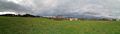
The view
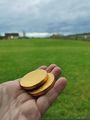
The coins
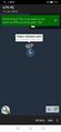
The proof [Sorry pros, I didn´t know I could add the point with the app at the time]

