Difference between revisions of "2023-01-19 1 103"
From Geohashing
DangerAspect (talk | contribs) (An expedition message sent via Geohash Droid for Android.) |
m (Location) |
||
| (4 intermediate revisions by 2 users not shown) | |||
| Line 14: | Line 14: | ||
== Location == | == Location == | ||
<!-- where you've surveyed the hash to be --> | <!-- where you've surveyed the hash to be --> | ||
| + | Grassy slope near Dhoby Ghaut/Fort Canning Park, between Canning Rise and Canning Walk. | ||
== Participants == | == Participants == | ||
<!-- who attended: If you link to your wiki user name in this section, your expedition will be picked up by the various statistics generated for geohashing. You may use three tildes ~ as a shortcut to automatically insert the user signature of the account you are editing with. | <!-- who attended: If you link to your wiki user name in this section, your expedition will be picked up by the various statistics generated for geohashing. You may use three tildes ~ as a shortcut to automatically insert the user signature of the account you are editing with. | ||
--> | --> | ||
| − | + | * [[User:DangerAspect|DangerAspect]] ([[User talk:DangerAspect|talk]]) | |
| − | |||
| − | |||
== Expedition == | == Expedition == | ||
<!-- how it all turned out. your narrative goes here. --> | <!-- how it all turned out. your narrative goes here. --> | ||
| − | + | Surprisingly accessible! Got a notification for a nearby Geohash, went to Dhoby Ghaut via public transport, and walked the rest of the way. | |
| − | |||
| − | |||
== Photos == | == Photos == | ||
| Line 33: | Line 30: | ||
--> | --> | ||
<gallery perrow="5"> | <gallery perrow="5"> | ||
| + | |||
| + | Image:2023-01-19_1_103_DangerAspect_1674125365713.jpg|This haspoint comes with a celebratory tunnel of lights! [https://openstreetmap.org/?mlat=1.29710920&mlon=103.84679550&zoom=16 @1.2971,103.8468] | ||
</gallery> | </gallery> | ||
== Achievements == | == Achievements == | ||
| + | <!-- Add any achievement ribbons you earned below, or remove this section --> | ||
{{#vardefine:ribbonwidth|100%}} | {{#vardefine:ribbonwidth|100%}} | ||
| − | + | {{Land geohash | latitude = 1 | longitude = 103 | date = 2023-01-19 | name = DangerAspect }} | |
| + | {{Public transport geohash | latitude = 1 | longitude = 103 | date = 2023-01-19 | busline = North-South Line | name = DangerAspect }} | ||
__NOTOC__ | __NOTOC__ | ||
| − | |||
| − | |||
| − | |||
| − | |||
| − | |||
| − | |||
| − | |||
| − | |||
| − | |||
| − | |||
| − | |||
| − | |||
| − | |||
| − | |||
[[Category:Expeditions]] | [[Category:Expeditions]] | ||
| − | |||
[[Category:Expeditions with photos]] | [[Category:Expeditions with photos]] | ||
| − | |||
| − | |||
| − | |||
| − | |||
| − | |||
[[Category:Coordinates reached]] | [[Category:Coordinates reached]] | ||
| − | + | {{location|SG|CS}} | |
| − | |||
| − | |||
| − | |||
| − | |||
| − | |||
| − | |||
| − | |||
| − | |||
| − | |||
| − | |||
| − | |||
| − | |||
| − | |||
| − | |||
| − | |||
| − | |||
| − | |||
Latest revision as of 19:42, 28 January 2023
| Thu 19 Jan 2023 in 1,103: 1.2971337, 103.8467990 geohashing.info google osm bing/os kml crox |
Location
Grassy slope near Dhoby Ghaut/Fort Canning Park, between Canning Rise and Canning Walk.
Participants
Expedition
Surprisingly accessible! Got a notification for a nearby Geohash, went to Dhoby Ghaut via public transport, and walked the rest of the way.
Photos
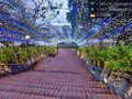
This haspoint comes with a celebratory tunnel of lights! @1.2971,103.8468

Achievements
DangerAspect earned the Land geohash achievement
|
DangerAspect earned the Public transport geohash achievement
|