Difference between revisions of "2023-02-23 -37 144"
([live picture]GPS) |
|||
| Line 1: | Line 1: | ||
| − | + | {{meetup graticule | |
| − | |||
| − | |||
| − | |||
| − | |||
| − | |||
| − | |||
| − | |||
| − | |||
| lat=-37 | | lat=-37 | ||
| lon=144 | | lon=144 | ||
| date=2023-02-23 | | date=2023-02-23 | ||
| − | }} | + | }} |
== Location == | == Location == | ||
| − | + | On the grassy side of the road where you'd expect a footpath to be, on Winifred St in Williamstown | |
== Participants == | == Participants == | ||
| − | + | [[User:Lachie|Lachie]] | |
| − | + | [[user:Johnwrw|John]] | |
== Plans == | == Plans == | ||
| Line 23: | Line 15: | ||
== Expedition == | == Expedition == | ||
| − | + | ===Expedition 1=== | |
| + | |||
| + | ===Expedition 2=== | ||
| + | When I awoke around 8, I looked at my phone, and saw that Lachie had already reached today's point as it was just down in Williamstown. I decided that I wanted to go too, and to also break my personal record from [[2022-02-11_-37_145|last February]] of 15.18km for a walk/run geohash. It was a similar distance away (11km), but this time I wouldn't chicken out and use trains on the way home, I would make the whole journey on foot. | ||
| + | |||
| + | I set off after 10, and jogged to the point with occasional walking breaks (to keep my HR from getting too high), while listening to a podcast. It all passed very smoothly. I reached the point after just over an hour and snapped the requisite selfie, and took the requisite screenshot. | ||
| + | I had thought of continuing to run on my way home, but my shoulder was starting to get tired and sore, so it was to be just walking for the return journey. I decided that I would take the slightly more scenic route on the way home, and headed east to the coast, whereupon I could follow the coast for a bit. | ||
| + | |||
| + | I was rewarded for this choice, by spotting a Pelican on the way. I did have to deal with a significant headwind though on the downside. | ||
| + | |||
| + | My feet were starting to get sore and blistery by the time I was getting towards the 15km mark, but I didn't have much choice, so I ploughed on. I stopped to get some liquorish from the Smithfield Rd IGA when I was almost home, and eventually reached home at about half past one, having done 23.3km in total. | ||
== Tracklog == | == Tracklog == | ||
| − | + | ||
== Photos == | == Photos == | ||
| Line 45: | Line 47: | ||
== Achievements == | == Achievements == | ||
{{#vardefine:ribbonwidth|100%}} | {{#vardefine:ribbonwidth|100%}} | ||
| − | + | {{Walk geohash | |
| + | |||
| + | | latitude = -37 | ||
| + | | longitude = 144 | ||
| + | | date = 2023-02-23 | ||
| + | | name = [[User:johnwrw|John]] | ||
| + | | distance = 23.3 kms | ||
| + | | image = | ||
| + | |||
| + | }} | ||
__NOTOC__ | __NOTOC__ | ||
| − | |||
| − | |||
| − | |||
| − | |||
| − | |||
| − | |||
| − | |||
| − | |||
| − | |||
| − | + | ||
[[Category:Expeditions]] | [[Category:Expeditions]] | ||
| − | + | ||
[[Category:Expeditions with photos]] | [[Category:Expeditions with photos]] | ||
| − | + | ||
| − | |||
| − | |||
| − | |||
| − | |||
[[Category:Coordinates reached]] | [[Category:Coordinates reached]] | ||
| − | |||
| − | |||
| − | |||
| − | |||
| − | |||
| − | |||
| − | |||
| − | |||
| − | |||
| − | |||
| − | |||
| − | |||
| − | |||
| − | |||
| − | |||
| − | |||
| − | |||
| − | |||
Revision as of 06:00, 23 February 2023
| Thu 23 Feb 2023 in -37,144: -37.8603301, 144.8871427 geohashing.info google osm bing/os kml crox |
Location
On the grassy side of the road where you'd expect a footpath to be, on Winifred St in Williamstown
Participants
Plans
Expedition
Expedition 1
Expedition 2
When I awoke around 8, I looked at my phone, and saw that Lachie had already reached today's point as it was just down in Williamstown. I decided that I wanted to go too, and to also break my personal record from last February of 15.18km for a walk/run geohash. It was a similar distance away (11km), but this time I wouldn't chicken out and use trains on the way home, I would make the whole journey on foot.
I set off after 10, and jogged to the point with occasional walking breaks (to keep my HR from getting too high), while listening to a podcast. It all passed very smoothly. I reached the point after just over an hour and snapped the requisite selfie, and took the requisite screenshot.
I had thought of continuing to run on my way home, but my shoulder was starting to get tired and sore, so it was to be just walking for the return journey. I decided that I would take the slightly more scenic route on the way home, and headed east to the coast, whereupon I could follow the coast for a bit.
I was rewarded for this choice, by spotting a Pelican on the way. I did have to deal with a significant headwind though on the downside.
My feet were starting to get sore and blistery by the time I was getting towards the 15km mark, but I didn't have much choice, so I ploughed on. I stopped to get some liquorish from the Smithfield Rd IGA when I was almost home, and eventually reached home at about half past one, having done 23.3km in total.
Tracklog
Photos

Made it
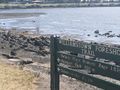
Pelican
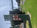
Curious what the giant eye represents
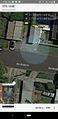
GPS


Achievements
John earned the Walk geohash Achievement
|