Difference between revisions of "2023-02-26 -37 145"
Felix Dance (talk | contribs) ([live picture]First obstacle) |
m (Location) |
||
| (14 intermediate revisions by 2 users not shown) | |||
| Line 1: | Line 1: | ||
| − | + | [[Image:{{{image|2023-02-26_-37_145_Felix Dance_1677453751233.jpg}}}|thumb|left]] | |
| − | + | {{meetup graticule | |
| − | |||
| − | |||
| − | |||
| − | |||
| − | |||
| − | |||
| lat=-37 | | lat=-37 | ||
| lon=145 | | lon=145 | ||
| date=2023-02-26 | | date=2023-02-26 | ||
| − | }} | + | }} |
| + | |||
== Location == | == Location == | ||
| − | + | In a field within a labyrinth of housing estate construction sites, in Wollert. | |
== Participants == | == Participants == | ||
| − | + | * [[User:Felix Dance|Felix Dance]] | |
| − | -- | + | |
| + | == Expedition == | ||
| + | I initially resisted this hash since I had a few things on, but once I realised our group's consecutive geohashing streak was imperiled, I shifted some things around and made sure I found the time to get out there. | ||
| + | |||
| + | Straight after my and my partner's birth class, I jumped on my bike, rode to Moonee Ponds Station and took the train north to Craigieburn. From here, I took the long, boring Craigieburn Rd east into the tailwind. | ||
| + | |||
| + | Soon, I arrived at some new housing developments, and Google directed me through a maze of half-constructed streets and desolate, liminal spaces, the old having been destroyed but the new waiting to be born - a place, as Gramsci would say, of monsters. | ||
| + | |||
| + | One of these streets Google directed me along was completely under construction, complete with a cyclone fence and angry, construction-y signs. Of course, I clambered around the poorly-linked fence panels and rode on it anyway, doing the same at the opposing side to pass through. This is where I started recording my track log below. | ||
| + | |||
| + | I then travelled east again, but this time along a restricted gravel road, rubbish-strewn on both sides. | ||
| + | |||
| + | And this is where I encountered my second obstacle - yet another uncompleted housing development that I needed to sneak through. This one was open to local traffic, though, which I guess is me. | ||
| − | + | After a short overshoot, I was next to the hash. I locked my bike, donned high-vis to pretend to be a government inspector of some sort, and climbed the low fence into an overgrown paddock. I was careful to watch for snakes. They'd love this place. | |
| − | |||
| − | + | Soon I was confident I would reach the hash. The metres ticked down from 200 to zero and I celebrated my success in the long grass by taking photos and observing my surroundings. | |
| − | + | ||
| + | A fox ran out from the hashpoint and over a small knoll. A pile of rocks faced me from the north. A rusty wind pump spun listlessly in the breeze, each rotation creaking at me like it would in a horror movie. | ||
| + | |||
| + | I turned around and returned to my bike. From here I retraced my route and made the train with 10 minutes to spare. An uneventful trip took me home. | ||
== Tracklog == | == Tracklog == | ||
| − | + | {{ Tracklog | 2023-02-26 -37 145 Wollert_geohash.gpx }} | |
== Photos == | == Photos == | ||
| − | |||
| − | |||
| − | |||
<gallery perrow="5"> | <gallery perrow="5"> | ||
| − | Image:2023-02-26_- | + | Image:2023-02-26_-37_145_Felix Dance_1677387028620.jpg|First obstacle |
| − | Image:2023-02-26_- | + | Image:2023-02-26_-37_145_Felix Dance_1677387054280.jpg|Deserted road |
| − | Image:2023-02-26_-37_145_Felix | + | Image:2023-02-26_-37_145_Felix Dance_1677387068398.jpg|Me riding |
| − | |||
| − | + | Image:2023-02-26_-37_145_Felix Dance_1677453751199.jpg|2nd obstacle | |
| − | |||
| − | |||
| − | + | Image:2023-02-26_-37_145_Felix Dance_1677453751233.jpg|Me at the hash | |
| − | |||
| − | |||
| − | |||
| − | + | Image:2023-02-26_-37_145_Felix Dance_1677453751253.jpg|Hash basalt | |
| − | + | Image:2023-02-26_-37_145_Felix Dance_1677453751263.jpg|GPS proof | |
| − | < | + | </gallery> |
| − | |||
| − | |||
| − | + | == Achievements == | |
| + | {{Bicycle geohash|latitude=-37|longitude=145|date=2023-02-26|name=[[User:Felix Dance|Felix Dance]]|distance=22km}} | ||
| − | |||
[[Category:Expeditions]] | [[Category:Expeditions]] | ||
| − | |||
[[Category:Expeditions with photos]] | [[Category:Expeditions with photos]] | ||
| − | |||
| − | |||
| − | |||
| − | |||
| − | |||
[[Category:Coordinates reached]] | [[Category:Coordinates reached]] | ||
| − | + | {{location|AU|VIC|WS}} | |
| − | |||
| − | |||
| − | |||
| − | |||
| − | |||
| − | |||
| − | |||
| − | |||
| − | |||
| − | |||
| − | |||
| − | |||
| − | |||
| − | |||
| − | |||
| − | |||
| − | |||
Latest revision as of 16:44, 7 March 2023

| Sun 26 Feb 2023 in -37,145: -37.5828367, 145.0235380 geohashing.info google osm bing/os kml crox |
Location
In a field within a labyrinth of housing estate construction sites, in Wollert.
Participants
Expedition
I initially resisted this hash since I had a few things on, but once I realised our group's consecutive geohashing streak was imperiled, I shifted some things around and made sure I found the time to get out there.
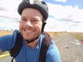
Straight after my and my partner's birth class, I jumped on my bike, rode to Moonee Ponds Station and took the train north to Craigieburn. From here, I took the long, boring Craigieburn Rd east into the tailwind.
Soon, I arrived at some new housing developments, and Google directed me through a maze of half-constructed streets and desolate, liminal spaces, the old having been destroyed but the new waiting to be born - a place, as Gramsci would say, of monsters.
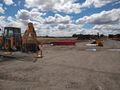
One of these streets Google directed me along was completely under construction, complete with a cyclone fence and angry, construction-y signs. Of course, I clambered around the poorly-linked fence panels and rode on it anyway, doing the same at the opposing side to pass through. This is where I started recording my track log below.
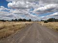
I then travelled east again, but this time along a restricted gravel road, rubbish-strewn on both sides.
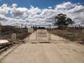
And this is where I encountered my second obstacle - yet another uncompleted housing development that I needed to sneak through. This one was open to local traffic, though, which I guess is me.
After a short overshoot, I was next to the hash. I locked my bike, donned high-vis to pretend to be a government inspector of some sort, and climbed the low fence into an overgrown paddock. I was careful to watch for snakes. They'd love this place.
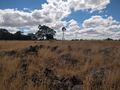
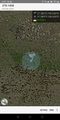
Soon I was confident I would reach the hash. The metres ticked down from 200 to zero and I celebrated my success in the long grass by taking photos and observing my surroundings.
A fox ran out from the hashpoint and over a small knoll. A pile of rocks faced me from the north. A rusty wind pump spun listlessly in the breeze, each rotation creaking at me like it would in a horror movie.
I turned around and returned to my bike. From here I retraced my route and made the train with 10 minutes to spare. An uneventful trip took me home.
Tracklog
Photos
First obstacle
Deserted road
Me riding
2nd obstacle
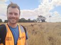
Me at the hash
Hash basalt
GPS proof


Achievements
Felix Dance earned the Bicycle geohash achievement
|