Difference between revisions of "2023-03-12 47 -122"
Michael5000 (talk | contribs) (Created page with "{{subst:Expedition}}") |
Heatherbee (talk | contribs) (→Expedition) |
||
| (7 intermediate revisions by 3 users not shown) | |||
| Line 13: | Line 13: | ||
}}<!-- edit as necessary --> | }}<!-- edit as necessary --> | ||
== Location == | == Location == | ||
| − | + | On a street in Northwest Olympia. | |
== Participants == | == Participants == | ||
| − | + | *[[user:Michael5000|Michael5000]] | |
| − | + | *[[User:Heatherbee|Heatherbee]] | |
| − | == | + | == Expedition == |
| − | + | Michael5000 -- that's me -- had noticed that there was an accessible hashpoint in Olympia, but that's a couple hours away. But then Heatherbee, who lives in Olympia, got in touch and there was some stuff to talk about and she was all like "do you have time for a call?" and I was all like "tell you what, let's do lunch tomorrow!" | |
| − | + | So I drove up to Olympia and went for a run on one of their trails, and then we went downtown for Thai food that somehow ended up being Indian food, and very tasty. At some point I revealed to Heatherbee that she was going geohashing, which obviously must have been very exciting for her. So, after lunch we drove out to the northwest for a few predictable episodes where I trusted my memory of the map more than the actual knowledge of the local person sitting next to me and stranded us on dead ends. | |
| − | |||
| − | + | Eventually, we got to the general area of the hashpoint. It's the kind of residential neighborhood that puts up ambiguously worded signs to discourage you from using the public roads, but we parked a few blocks off and shambled down to the hashpoint. The neighborhood slopes steeply down to an arm of Puget Sound. Kinda pretty. | |
| − | |||
== Photos == | == Photos == | ||
| − | |||
| − | |||
| − | |||
<gallery perrow="5"> | <gallery perrow="5"> | ||
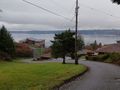
| + | File:2023-03-12 47 -122 3.jpg|The hashpoint is kind of down around that curve. | ||
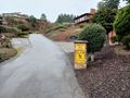
| + | File:2023-03-12 47 -122 2.jpg|Just off the right side of this little road. | ||
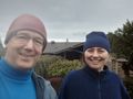
| + | File:2023-03-12 47 -122 1.jpg|Here we are! | ||
| + | File:2023-03-12 47 -122 4.jpg|Ta da! | ||
</gallery> | </gallery> | ||
== Achievements == | == Achievements == | ||
{{#vardefine:ribbonwidth|100%}} | {{#vardefine:ribbonwidth|100%}} | ||
| − | |||
| − | + | {{drag-along | |
| − | |||
| − | |||
| − | |||
| − | + | | latitude = 47 | |
| + | | longitude = -122 | ||
| + | | date = 2023-03-12 | ||
| + | | partner = Heather | ||
| + | | name = Michael5000 | ||
| + | | image = 2023-03-12 47 -122 1.jpg | ||
| − | + | }} | |
| − | + | * Heather's first Expedition ever. | |
| − | |||
| − | |||
| − | + | __NOTOC__ | |
| − | |||
| − | |||
[[Category:Expeditions]] | [[Category:Expeditions]] | ||
| − | |||
[[Category:Expeditions with photos]] | [[Category:Expeditions with photos]] | ||
| − | |||
| − | |||
| − | |||
| − | |||
| − | |||
[[Category:Coordinates reached]] | [[Category:Coordinates reached]] | ||
| − | + | {{location|US|WA|TH}} | |
| − | |||
| − | |||
| − | |||
| − | |||
| − | |||
| − | |||
| − | |||
| − | |||
| − | |||
| − | |||
| − | |||
| − | |||
| − | |||
| − | |||
| − | |||
| − | |||
| − | |||
Latest revision as of 16:39, 1 April 2023
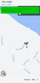
| Sun 12 Mar 2023 in 47,-122: 47.0772048, -122.9289026 geohashing.info google osm bing/os kml crox |
Location
On a street in Northwest Olympia.
Participants
Expedition
Michael5000 -- that's me -- had noticed that there was an accessible hashpoint in Olympia, but that's a couple hours away. But then Heatherbee, who lives in Olympia, got in touch and there was some stuff to talk about and she was all like "do you have time for a call?" and I was all like "tell you what, let's do lunch tomorrow!"
So I drove up to Olympia and went for a run on one of their trails, and then we went downtown for Thai food that somehow ended up being Indian food, and very tasty. At some point I revealed to Heatherbee that she was going geohashing, which obviously must have been very exciting for her. So, after lunch we drove out to the northwest for a few predictable episodes where I trusted my memory of the map more than the actual knowledge of the local person sitting next to me and stranded us on dead ends.
Eventually, we got to the general area of the hashpoint. It's the kind of residential neighborhood that puts up ambiguously worded signs to discourage you from using the public roads, but we parked a few blocks off and shambled down to the hashpoint. The neighborhood slopes steeply down to an arm of Puget Sound. Kinda pretty.
Photos
The hashpoint is kind of down around that curve.
Just off the right side of this little road.
Here we are!
Ta da!


Achievements
Michael5000 earned the Drag-along achievement
|
- Heather's first Expedition ever.