Difference between revisions of "2023-03-16 32 34"
Yerushalmi (talk | contribs) (→Location) |
m (Location) |
||
| (6 intermediate revisions by 2 users not shown) | |||
| Line 1: | Line 1: | ||
| − | + | {{meetup graticule | |
| − | |||
| − | |||
| − | |||
| − | |||
| − | |||
| − | |||
| − | |||
| − | |||
| lat=32 | | lat=32 | ||
| lon=34 | | lon=34 | ||
| Line 18: | Line 10: | ||
== Participants == | == Participants == | ||
| − | + | [[User:Yerushalmi|Yerushalmi]] ([[User talk:Yerushalmi|talk]]) | |
| − | |||
== Plans == | == Plans == | ||
| − | + | My usual train day plan: Take the uncomfortable train from Jerusalem to Paatei Modi'in, switch to the comfortable train, work from the train all day, get off at the station nearest the hashpoint, take the bus to the general hashpoint area, walk to the hashpoint, walk back to the bus stop, eat lunch somewhere near by, get back on the train, continue working. | |
== Expedition == | == Expedition == | ||
| − | + | Plan went off without a hitch. Got off at the Caeserea train station, took the 11 bus to the Pal Yam junction, walked to one of the several paths entering the field (there were no No Entry signs at that entrance - it's apparently not the dangerous part), walked south. | |
| − | + | I was leaving clear footprints in the soft, rich floodplain soil. Never saw ground like that in my life. | |
| − | + | ||
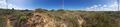
| + | The hashpoint was about 60 meters off the path in brambles. Long pants and boots to the rescue. Reached the hashpoint, took a screenshot of Geohash Droid, took a panorama photograph, walked back the way I came. | ||
| + | |||
| + | Took the bus afterwards to a local mall to eat <span style="text-decoration:line-through;">lunch</span> rubber at a McDonalds, then another bus back to the train, resumed working. | ||
== Photos == | == Photos == | ||
| Line 35: | Line 29: | ||
--> | --> | ||
<gallery perrow="5"> | <gallery perrow="5"> | ||
| + | Image:20230316_110412.jpg | Witty Comment | ||
| + | Image:Screenshot_20230316_110335_Geohash Droid.jpg | Another Witty Comment | ||
</gallery> | </gallery> | ||
| Line 42: | Line 38: | ||
__NOTOC__ | __NOTOC__ | ||
| − | |||
| − | |||
| − | |||
| − | |||
| − | |||
| − | |||
| − | |||
| − | |||
| − | |||
| − | |||
| − | |||
| − | |||
| − | |||
| − | |||
[[Category:Expeditions]] | [[Category:Expeditions]] | ||
| − | + | [[Category:Coordinates reached]] | |
[[Category:Expeditions with photos]] | [[Category:Expeditions with photos]] | ||
| − | + | {{location|IL|HA|HD}} | |
| − | |||
| − | |||
| − | |||
| − | |||
| − | |||
| − | |||
| − | |||
| − | |||
| − | |||
| − | |||
| − | |||
| − | |||
| − | |||
| − | |||
| − | |||
| − | |||
| − | |||
| − | |||
| − | |||
| − | |||
| − | |||
| − | |||
| − | |||
Latest revision as of 20:43, 23 April 2023
| Thu 16 Mar 2023 in 32,34: 32.4678330, 34.9217084 geohashing.info google osm bing/os kml crox |
Location
A field outside of Caesarea, Israel. Google Maps investigation show part or all of it to belong to the Water Authority, with No Trespassing signs. Amud Anan says the northern part of the field is often flooded due to collecting water from rivers to the NE, and that the southern part is often used by ruffians doing stunts with offroad vehicles.
Luckily the point is in the southern part!
Participants
Plans
My usual train day plan: Take the uncomfortable train from Jerusalem to Paatei Modi'in, switch to the comfortable train, work from the train all day, get off at the station nearest the hashpoint, take the bus to the general hashpoint area, walk to the hashpoint, walk back to the bus stop, eat lunch somewhere near by, get back on the train, continue working.
Expedition
Plan went off without a hitch. Got off at the Caeserea train station, took the 11 bus to the Pal Yam junction, walked to one of the several paths entering the field (there were no No Entry signs at that entrance - it's apparently not the dangerous part), walked south.
I was leaving clear footprints in the soft, rich floodplain soil. Never saw ground like that in my life.
The hashpoint was about 60 meters off the path in brambles. Long pants and boots to the rescue. Reached the hashpoint, took a screenshot of Geohash Droid, took a panorama photograph, walked back the way I came.
Took the bus afterwards to a local mall to eat lunch rubber at a McDonalds, then another bus back to the train, resumed working.
Photos
Witty Comment

Another Witty Comment
