Difference between revisions of "2023-04-15 56 -3"
From Geohashing
(create) |
m (Location) |
||
| (11 intermediate revisions by one other user not shown) | |||
| Line 14: | Line 14: | ||
== Location == | == Location == | ||
<!-- where you've surveyed the hash to be --> | <!-- where you've surveyed the hash to be --> | ||
| + | Near Cowdenbeath | ||
== Participants == | == Participants == | ||
| − | + | [[User:jsk|jsk]] | |
| − | |||
== Plans == | == Plans == | ||
<!-- what were the original plans --> | <!-- what were the original plans --> | ||
| − | + | It's close to the train line. I could take the train to Cowdenbeath or Lochgelly on Saturday and run 4km out and back. | |
== Expedition == | == Expedition == | ||
<!-- how it all turned out. your narrative goes here. --> | <!-- how it all turned out. your narrative goes here. --> | ||
| + | Although I initially believed I would be reflowering the graticule after 10 years 13 days of inactivity, there was [[2016-05-25_56_-3|another successful expedition]] in 2016. | ||
== Tracklog == | == Tracklog == | ||
| − | < | + | |
| + | <gallery> | ||
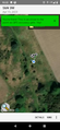
| + | File:cowdenbeath-geohashdroid2.png | geohash droid proof | ||
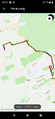
| + | File:cowdenbeath-garmin.png.png | garmin run from train station to hash | ||
| + | </gallery> | ||
== Photos == | == Photos == | ||
| Line 33: | Line 38: | ||
--> | --> | ||
<gallery perrow="5"> | <gallery perrow="5"> | ||
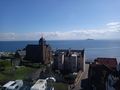
| + | cowdenbeath1.jpg | Seeing the coast from the train | ||
| + | inverkeithing.jpg | 10 minutes in Inverkeithing | ||
| + | cowdenbeath5.jpg | The landscape | ||
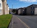
| + | cowdenbeath3.jpg | The spot is by the small tree | ||
| + | fencefungus.jpg | Spiky fence post fungus. | ||
| + | cowdenbeath4.jpg | View of Cowdenbeath from warmemorial | ||
</gallery> | </gallery> | ||
== Achievements == | == Achievements == | ||
{{#vardefine:ribbonwidth|100%}} | {{#vardefine:ribbonwidth|100%}} | ||
| − | + | {{land geohash | |
| + | |||
| + | | latitude = 56 | ||
| + | | longitude = -3 | ||
| + | | date = 2023-04-15 | ||
| + | | name = jsk | ||
| + | |||
| + | }} | ||
| + | |||
| + | {{Minesweeper geohash | ||
| + | |||
| + | | graticule = Edinburgh, United Kingdom | ||
| + | | ranknumber = 2 | ||
| + | | ne = true | ||
| + | | n = true | ||
| + | | name = jsk | ||
| + | |||
| + | }} | ||
__NOTOC__ | __NOTOC__ | ||
<!-- =============== USEFUL CATEGORIES FOLLOW ================ | <!-- =============== USEFUL CATEGORIES FOLLOW ================ | ||
Delete the next line ONLY if you have chosen the appropriate categories below. If you are unsure, don't worry. People will read your report and help you with the classification. --> | Delete the next line ONLY if you have chosen the appropriate categories below. If you are unsure, don't worry. People will read your report and help you with the classification. --> | ||
| − | |||
| − | |||
| − | |||
| − | |||
| − | |||
| − | |||
| − | |||
| − | |||
| − | |||
| − | |||
| − | |||
[[Category:Expeditions]] | [[Category:Expeditions]] | ||
| − | |||
[[Category:Expeditions with photos]] | [[Category:Expeditions with photos]] | ||
| − | + | ||
| − | |||
| − | |||
| − | |||
[[Category:Coordinates reached]] | [[Category:Coordinates reached]] | ||
| − | + | {{location|GB|SCT|FIF}} | |
| − | |||
| − | |||
| − | |||
| − | |||
| − | |||
| − | |||
| − | |||
| − | |||
| − | |||
| − | |||
| − | |||
| − | |||
| − | |||
| − | |||
| − | |||
| − | |||
| − | |||
Latest revision as of 11:42, 21 April 2023
| Sat 15 Apr 2023 in 56,-3: 56.1250593, -3.3806833 geohashing.info google osm bing/os kml crox |
Location
Near Cowdenbeath
Participants
Plans
It's close to the train line. I could take the train to Cowdenbeath or Lochgelly on Saturday and run 4km out and back.
Expedition
Although I initially believed I would be reflowering the graticule after 10 years 13 days of inactivity, there was another successful expedition in 2016.
Tracklog
geohash droid proof
garmin run from train station to hash


Photos
Seeing the coast from the train
10 minutes in Inverkeithing
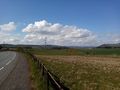
The landscape

The spot is by the small tree
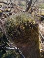
Spiky fence post fungus.
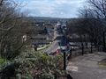
View of Cowdenbeath from warmemorial


Achievements
jsk earned the Land geohash achievement
|
jsk achieved level 2 of the Minesweeper Geohash achievement
|