Difference between revisions of "2023-04-22 48 7"
(→Location) |
(Coordinates reached) |
||
| Line 5: | Line 5: | ||
}} | }} | ||
== Location == | == Location == | ||
| − | + | Next to a mountain bike trail in [[wikipedia:Barr, Bas-Rhin|Barr]]. | |
== Participants == | == Participants == | ||
* [[User:Baarde|Baarde]] | * [[User:Baarde|Baarde]] | ||
| + | * a mountain biker | ||
== Plans == | == Plans == | ||
[[User:Baarde|Baarde]] will cycle from Sélestat to the geohash. He should be there at 16:00 o'clock. | [[User:Baarde|Baarde]] will cycle from Sélestat to the geohash. He should be there at 16:00 o'clock. | ||
| + | |||
| + | == Expedition == | ||
| + | The road from Sélestat to Baar was very unexceptional. I took the EuroVelo 5, a cycle route that goes through a series of wine villages at the foot of the Vosges mountains. Once in Baar, I turned West and started the climb toward Mont Sainte-Odile. Shortly after the end of the town, I exited the road, took a forest path and left my bicycle at the bottom of a steep hill. | ||
| + | |||
| + | On reaching the ridge of the hill, I noticed a mountain bike trail that was heading toward the road with a much gentler slope and fewer trees than the path I had improvised to get up there. I also met a young mountain biker who was descending the trail at considerable speed. We exchanged two words (''Bonjour'', twice) before he disappeared behind a bend. The coordinates were located only a few meters from the trail. So, using [[wikipedia:Uncertainty principle|Heisenberg's uncertainty principle]], we will assume he did reach the coordinates. | ||
| + | |||
| + | I arrived at 15:55. I waited a few minutes until [[Saturday meetup]]'s official time, recorded proof, then left. It started raining on the way back and I was slightly damp by the time I reached home. Still, it was a very nice expedition. | ||
| + | |||
| + | == Photos == | ||
| + | <gallery> | ||
| + | File:2023-04-22 48 7 01.jpg | Cycling to Baarr | ||
| + | File:2023-04-22 48 7 02.jpg | In Barr | ||
| + | File:2023-04-22 48 7 03.jpg | Below the geohash | ||
| + | File:2023-04-22 48 7 04.jpg | Surroundings (North) | ||
| + | File:2023-04-22 48 7 05.jpg | Surroundings (South-East) | ||
| + | File:2023-04-22 48 7 06.jpg | Surroundings (South-West) | ||
| + | File:2023-04-22 48 7 07.jpg | Stupid grin | ||
| + | File:2023-04-22 48 7 08.png | Coordinates reached | ||
| + | </gallery> | ||
| + | |||
| + | == Achievements == | ||
| + | {{#vardefine:ribbonwidth|100%}} | ||
| + | {{land geohash | ||
| + | | latitude = 48 | ||
| + | | longitude = 7 | ||
| + | | date = 2023-04-22 | ||
| + | | name = [[User:Baarde|Baarde]] and a mountain biker (probably) | ||
| + | }} | ||
| + | {{bicycle geohash | ||
| + | | latitude = 48 | ||
| + | | longitude = 7 | ||
| + | | date = 2023-04-22 | ||
| + | | name = [[User:Baarde|Baarde]] and a mountain biker (probably) | ||
| + | | distance = 56 km and an unknown distance | ||
| + | | bothways = true | ||
| + | }} | ||
| + | {{xkcd centurion | ||
| + | | name = [[User:Baarde|Baarde]] | ||
| + | | count = 11 | ||
| + | }} | ||
__NOTOC__ | __NOTOC__ | ||
[[Category:Expeditions]] | [[Category:Expeditions]] | ||
| + | [[Category:Expeditions with photos]] | ||
| + | [[Category:Coordinates reached]] | ||
{{location|FR|67}} | {{location|FR|67}} | ||
Latest revision as of 17:40, 23 April 2023
| Sat 22 Apr 2023 in 48,7: 48.4116799, 7.4024735 geohashing.info google osm bing/os kml crox |
Location
Next to a mountain bike trail in Barr.
Participants
- Baarde
- a mountain biker
Plans
Baarde will cycle from Sélestat to the geohash. He should be there at 16:00 o'clock.
Expedition
The road from Sélestat to Baar was very unexceptional. I took the EuroVelo 5, a cycle route that goes through a series of wine villages at the foot of the Vosges mountains. Once in Baar, I turned West and started the climb toward Mont Sainte-Odile. Shortly after the end of the town, I exited the road, took a forest path and left my bicycle at the bottom of a steep hill.
On reaching the ridge of the hill, I noticed a mountain bike trail that was heading toward the road with a much gentler slope and fewer trees than the path I had improvised to get up there. I also met a young mountain biker who was descending the trail at considerable speed. We exchanged two words (Bonjour, twice) before he disappeared behind a bend. The coordinates were located only a few meters from the trail. So, using Heisenberg's uncertainty principle, we will assume he did reach the coordinates.
I arrived at 15:55. I waited a few minutes until Saturday meetup's official time, recorded proof, then left. It started raining on the way back and I was slightly damp by the time I reached home. Still, it was a very nice expedition.
Photos
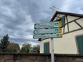
Cycling to Baarr
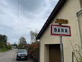
In Barr
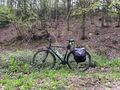
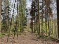
Below the geohash
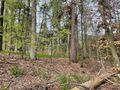
Surroundings (North)
Surroundings (South-East)
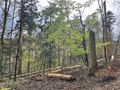
Surroundings (South-West)
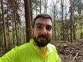
Stupid grin
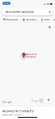
Coordinates reached


Achievements
Baarde and a mountain biker (probably) earned the Land geohash achievement
|
Baarde and a mountain biker (probably) earned the Bicycle geohash achievement
|
Baarde earned the xkcd Decurion achievement
|