Difference between revisions of "2023-04-28 -37 145"
(→Location) |
m (Location) |
||
| (2 intermediate revisions by 2 users not shown) | |||
| Line 1: | Line 1: | ||
| − | + | {{meetup graticule | |
| − | |||
| − | |||
| − | |||
| − | |||
| − | |||
| − | |||
| − | |||
| − | |||
| lat=-37 | | lat=-37 | ||
| lon=145 | | lon=145 | ||
| date=2023-04-28 | | date=2023-04-28 | ||
| − | }} | + | }} |
== Location == | == Location == | ||
| − | |||
Under some large power lines near Target Road, in upper Templestowe. | Under some large power lines near Target Road, in upper Templestowe. | ||
== Participants == | == Participants == | ||
| − | + | *[[User:Thomasha|Tom]] | |
| − | |||
| − | [[User:Thomasha|Tom]] | ||
== Plans == | == Plans == | ||
| − | I was informed by Felix that there was a convenient | + | Early in the morning I was informed by Felix that there was a convenient hash in the north east of Melbourne. This was perfect as my son was at child care and I had the day off work. So I got the required chores done, had lunch, then headed off on the gravel bike. |
| − | |||
== Expedition == | == Expedition == | ||
| − | |||
I'm fortunate enough to live near the Yarra, so the trip consisted of riding to the upper end of the Main Yarra Trail, at least until it becomes inaccessible near Mullum Mullum Creek. I followed the Mullum Mullum Creek Trail for a short distance then used satellite images to find a route through to Target Rd. After choosing my spot, I stumbled across some MTB jumps in some open forest and instantly regretted my bike choice. Getting through to Target Rd took minimal effort and after a few hundred metres of very undulating dirt road, all that was left was to choose where to jump the cyclone fence. I chose the more conservative option of walking down the hill 70m to a lower locked gate as this was my first hash since turning forty:) | I'm fortunate enough to live near the Yarra, so the trip consisted of riding to the upper end of the Main Yarra Trail, at least until it becomes inaccessible near Mullum Mullum Creek. I followed the Mullum Mullum Creek Trail for a short distance then used satellite images to find a route through to Target Rd. After choosing my spot, I stumbled across some MTB jumps in some open forest and instantly regretted my bike choice. Getting through to Target Rd took minimal effort and after a few hundred metres of very undulating dirt road, all that was left was to choose where to jump the cyclone fence. I chose the more conservative option of walking down the hill 70m to a lower locked gate as this was my first hash since turning forty:) | ||
On the return trip I found an even easier short cut to the Mullum Mullum Creek, but it wasn't enough to get me home before the rain. Still, a wonderful way to spend an overcast Melbourne autumnal afternoon. | On the return trip I found an even easier short cut to the Mullum Mullum Creek, but it wasn't enough to get me home before the rain. Still, a wonderful way to spend an overcast Melbourne autumnal afternoon. | ||
| − | |||
| − | |||
| − | |||
== Photos == | == Photos == | ||
| − | |||
| − | |||
| − | |||
<gallery perrow="5"> | <gallery perrow="5"> | ||
| − | |||
Image:2023-04-28_-37_145_lachie_1682722796845.jpg|Proof! | Image:2023-04-28_-37_145_lachie_1682722796845.jpg|Proof! | ||
| − | |||
Image:2023-04-28_-37_145_lachie_1682722892833.jpg|View from the hash. How's the serenity? | Image:2023-04-28_-37_145_lachie_1682722892833.jpg|View from the hash. How's the serenity? | ||
| − | |||
Image:2023-04-28_-37_145_lachie_1682722949886.jpg|Gate | Image:2023-04-28_-37_145_lachie_1682722949886.jpg|Gate | ||
| − | |||
Image:2023-04-28_-37_145_lachie_1682722969569.jpg|Target Road | Image:2023-04-28_-37_145_lachie_1682722969569.jpg|Target Road | ||
</gallery> | </gallery> | ||
| Line 53: | Line 30: | ||
__NOTOC__ | __NOTOC__ | ||
| − | |||
| − | |||
| − | |||
| − | |||
| − | |||
| − | |||
| − | |||
| − | |||
| − | |||
| − | |||
| − | |||
| − | |||
| − | |||
| − | |||
[[Category:Expeditions]] | [[Category:Expeditions]] | ||
| − | |||
[[Category:Expeditions with photos]] | [[Category:Expeditions with photos]] | ||
| − | |||
| − | |||
| − | |||
| − | |||
| − | |||
[[Category:Coordinates reached]] | [[Category:Coordinates reached]] | ||
| − | + | {{location|AU|VIC|MN}} | |
| − | |||
| − | |||
| − | |||
| − | |||
| − | |||
| − | |||
| − | |||
| − | |||
| − | |||
| − | |||
| − | |||
| − | |||
| − | |||
| − | |||
| − | |||
| − | |||
| − | |||
Latest revision as of 18:44, 10 May 2023
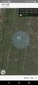
| Fri 28 Apr 2023 in -37,145: -37.7424100, 145.1772494 geohashing.info google osm bing/os kml crox |
Location
Under some large power lines near Target Road, in upper Templestowe.
Participants
Plans
Early in the morning I was informed by Felix that there was a convenient hash in the north east of Melbourne. This was perfect as my son was at child care and I had the day off work. So I got the required chores done, had lunch, then headed off on the gravel bike.
Expedition
I'm fortunate enough to live near the Yarra, so the trip consisted of riding to the upper end of the Main Yarra Trail, at least until it becomes inaccessible near Mullum Mullum Creek. I followed the Mullum Mullum Creek Trail for a short distance then used satellite images to find a route through to Target Rd. After choosing my spot, I stumbled across some MTB jumps in some open forest and instantly regretted my bike choice. Getting through to Target Rd took minimal effort and after a few hundred metres of very undulating dirt road, all that was left was to choose where to jump the cyclone fence. I chose the more conservative option of walking down the hill 70m to a lower locked gate as this was my first hash since turning forty:) On the return trip I found an even easier short cut to the Mullum Mullum Creek, but it wasn't enough to get me home before the rain. Still, a wonderful way to spend an overcast Melbourne autumnal afternoon.
Photos
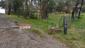
Proof!
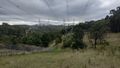
View from the hash. How's the serenity?
Gate
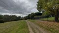
Target Road


