Difference between revisions of "2023-04-29 42 -117"
Michael5000 (talk | contribs) (→Location) |
m (per Renaming Proposal) |
||
| (10 intermediate revisions by 2 users not shown) | |||
| Line 13: | Line 13: | ||
}}<!-- edit as necessary --> | }}<!-- edit as necessary --> | ||
== Location == | == Location == | ||
| − | A few miles south of Jordan Valley. | + | A few miles south of the village of Jordan Valley. |
== Participants == | == Participants == | ||
*[[user:Michael5000|Michael5000]] | *[[user:Michael5000|Michael5000]] | ||
| − | == | + | == Expedition == |
| − | + | From [[2023-04-29 42 -118]], I continued on Oregon 78 to Burns Junction, which consists mostly of an abandoned gas station, then northwest through mighty Rome (a village of perhaps a dozen people), and eventually to the most urban and cosmopolitan place I'd seen in in 135 miles: Jordan Valley, Oregon, population 180. | |
| − | + | The hashpoint was south of town; Dinwitty Lane crossed some fields and then ran right through a ranching operation and over a little bridge; then, unsigned Sheep Spring Road split off and ran between fields and sagebrush for a while. When the road surface started to get a little iffy, I turned the truck around and pulled out the bicycle. | |
| − | + | ||
| + | The bicycle took me another 1.1 miles. By then, I was only a quarter mile out, so it was a shorter walk across sagebrush than either of the last two expeditions. | ||
| − | + | After the expedition, I stopped in Jordan Valley to have lunch and coffee at the Rockhouse Cafe, which is the traditional post-geohashing celebration for this area established by Eldin and Pojana after [[2013-03-03 43 -117]]. "Sugar, Sugar" (The Archies, 1969) was playing cheerfully on their stereo when I came in, which helped me avoid any unnecessary philosophical musings about the vastness of the Western landscape or the human experience of space. Good coffee, too. | |
| − | |||
== Photos == | == Photos == | ||
| − | |||
| − | |||
| − | |||
<gallery perrow="5"> | <gallery perrow="5"> | ||
| + | File:2023-04-29 42 -117 1.jpg|Parking the truck and launching the bike. | ||
| + | File:2023-04-29 42 -117 2.jpg|Sheep Spring Road. | ||
| + | File:2023-04-29 42 -117 3.jpg|The sun-bleached bones of less fortunate geohashers? | ||
| + | File:2023-04-29 42 -117 4.jpg|Boom. | ||
| + | File:2023-04-29 42 -117 5.jpg|Me, at the hashpoint. | ||
| + | File:2023-04-29 42 -117 6.jpg|Another view from a sagebrush hashpoint. | ||
| + | File:2023-04-29 42 -117 7.jpg|Some snowcapped mountains off in the distance. | ||
| + | File:2023-04-29 42 -117 8.jpg|Cows that I startled out of the road on the return ride. | ||
| + | File:2023-04-29 42 -117 9.jpg|The Rockhouse Cafe. | ||
</gallery> | </gallery> | ||
| Line 37: | Line 43: | ||
{{#vardefine:ribbonwidth|100%}} | {{#vardefine:ribbonwidth|100%}} | ||
| − | {{ | + | {{Graticule unlocked |
| latitude = 42 | | latitude = 42 | ||
| Line 88: | Line 94: | ||
__NOTOC__ | __NOTOC__ | ||
| − | |||
| − | |||
| − | |||
| − | |||
| − | |||
| − | |||
| − | |||
| − | |||
| − | |||
| − | |||
| − | |||
| − | |||
| − | |||
| − | |||
[[Category:Expeditions]] | [[Category:Expeditions]] | ||
| − | |||
[[Category:Expeditions with photos]] | [[Category:Expeditions with photos]] | ||
| − | |||
| − | |||
| − | |||
| − | |||
| − | |||
[[Category:Coordinates reached]] | [[Category:Coordinates reached]] | ||
| − | + | {{location|US|OR|ML}} | |
| − | |||
| − | |||
| − | |||
| − | |||
| − | |||
| − | |||
| − | |||
| − | |||
| − | |||
| − | |||
| − | |||
| − | |||
| − | |||
| − | |||
| − | |||
| − | |||
| − | |||
Latest revision as of 04:41, 20 March 2024
| Sat 29 Apr 2023 in 42,-117: 42.9242121, -117.0481861 geohashing.info google osm bing/os kml crox |
Location
A few miles south of the village of Jordan Valley.
Participants
Expedition
From 2023-04-29 42 -118, I continued on Oregon 78 to Burns Junction, which consists mostly of an abandoned gas station, then northwest through mighty Rome (a village of perhaps a dozen people), and eventually to the most urban and cosmopolitan place I'd seen in in 135 miles: Jordan Valley, Oregon, population 180.
The hashpoint was south of town; Dinwitty Lane crossed some fields and then ran right through a ranching operation and over a little bridge; then, unsigned Sheep Spring Road split off and ran between fields and sagebrush for a while. When the road surface started to get a little iffy, I turned the truck around and pulled out the bicycle.
The bicycle took me another 1.1 miles. By then, I was only a quarter mile out, so it was a shorter walk across sagebrush than either of the last two expeditions.
After the expedition, I stopped in Jordan Valley to have lunch and coffee at the Rockhouse Cafe, which is the traditional post-geohashing celebration for this area established by Eldin and Pojana after 2013-03-03 43 -117. "Sugar, Sugar" (The Archies, 1969) was playing cheerfully on their stereo when I came in, which helped me avoid any unnecessary philosophical musings about the vastness of the Western landscape or the human experience of space. Good coffee, too.
Photos
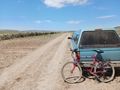
Parking the truck and launching the bike.
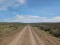
Sheep Spring Road.
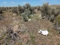
The sun-bleached bones of less fortunate geohashers?
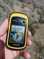
Boom.
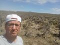
Me, at the hashpoint.
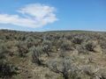
Another view from a sagebrush hashpoint.
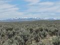
Some snowcapped mountains off in the distance.
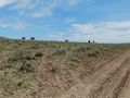
Cows that I startled out of the road on the return ride.
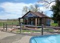
The Rockhouse Cafe.


Achievements
Michael5000 earned the Graticule Unlocked Achievement
|
Michael5000 earned the Multihash Achievement
|
Michael5000 earned the Consecutive geohash achievement
|
Michael5000 achieved level 5 of the Minesweeper Geohash achievement
|
Michael5000 achieved level 5 of the Minesweeper Geohash achievement
|