Difference between revisions of "2023-04-29 42 -118"
Michael5000 (talk | contribs) (→Achievements) |
m (per Renaming Proposal) |
||
| (9 intermediate revisions by 2 users not shown) | |||
| Line 13: | Line 13: | ||
}}<!-- edit as necessary --> | }}<!-- edit as necessary --> | ||
== Location == | == Location == | ||
| − | + | In sagebrush a mile and a half southwest from Highway 78. | |
== Participants == | == Participants == | ||
*[[user:Michael5000|Michael5000]] | *[[user:Michael5000|Michael5000]] | ||
| − | |||
| − | |||
== Expedition == | == Expedition == | ||
| − | + | There aren't many roads in the southeast corner of Oregon, and the terrain can be pretty stark, so it's a pretty challenging geohashing environment. On the plus side, though, it is almost entirely public land held by the Bureau of Land Management, so although the hashpoints aren't necessarily ''inviting'', they are usually legally accessible. | |
| − | + | So it was that I pulled over to the side of State Highway 78 and walked into the desert. It's hard not to feel conspicuous and self-conscious, since someone walking off across the sagebrush is easily the most noteworthy thing happening as far as the eye can see. Except, there's no eyes watching. Somebody drives by on Highway 78 every two or three minutes, maybe. | |
| − | + | ||
| + | The hashpoint was about a mile and a half from the road, generally upward, and there was some variation along the way. The sagebrush got denser or thinner, the soil rockier or smoother, cacti were present sometimes and not other times. But basically, it's a very big sagebrush desert, and there's a whole lot of sameness to it. I found a hashpoint out there. | ||
| + | |||
| + | Then I walked back the way I came, got to the truck, and continued on to [[2023-04-29 42 -117]]. | ||
== Photos == | == Photos == | ||
| − | |||
| − | |||
| − | |||
<gallery perrow="5"> | <gallery perrow="5"> | ||
| − | </gallery> | + | File:2023-04-29 42 -118 1.jpg|The truck at the side of Hwy 78. |
| + | File:2023-04-29 42 -118 2.jpg|The hashpoint is near the ridge at the horizon. | ||
| + | File:2023-04-29 42 -118 3.jpg|And there I was! | ||
| + | File:2023-04-29 42 -118 6.jpg|The hashpointsagebrush. | ||
| + | File:2023-04-29 42 -118 5.jpg|Looking to the northeast. | ||
| + | File:2023-04-29 42 -118 8.jpg|Looking south. | ||
| + | File:2023-04-29 42 -118 9.jpg|Looking northwest. | ||
| + | File:2023-04-29 42 -118 11.jpg|Me!</gallery> | ||
== Achievements == | == Achievements == | ||
{{#vardefine:ribbonwidth|100%}} | {{#vardefine:ribbonwidth|100%}} | ||
| − | {{ | + | {{Graticule unlocked |
| latitude = 42 | | latitude = 42 | ||
| Line 65: | Line 70: | ||
}} | }} | ||
| + | |||
| + | {{Minesweeper geohash | ||
| + | | graticule = [[Hines, Oregon]] | ||
| + | | ranknumber = 6 | ||
| + | | sw = true | ||
| + | | w = true | ||
| + | | nw = true | ||
| + | | ne = true | ||
| + | | e = true | ||
| + | | se = true | ||
| + | | name = [[User:Michael5000|Michael5000]] | ||
| + | }} | ||
__NOTOC__ | __NOTOC__ | ||
| − | |||
| − | |||
| − | |||
| − | |||
| − | |||
| − | |||
| − | |||
| − | |||
| − | |||
| − | |||
| − | |||
| − | |||
| − | |||
[[Category:Expeditions]] | [[Category:Expeditions]] | ||
| − | |||
[[Category:Expeditions with photos]] | [[Category:Expeditions with photos]] | ||
| − | |||
| − | |||
| − | |||
| − | |||
| − | |||
[[Category:Coordinates reached]] | [[Category:Coordinates reached]] | ||
| − | + | {{location|US|OR|ML}} | |
| − | |||
| − | |||
| − | |||
| − | |||
| − | |||
| − | |||
| − | |||
| − | |||
| − | |||
| − | |||
| − | |||
| − | |||
| − | |||
| − | |||
| − | |||
| − | |||
| − | |||
Latest revision as of 04:41, 20 March 2024
| Sat 29 Apr 2023 in 42,-118: 42.9242121, -118.0481861 geohashing.info google osm bing/os kml crox |
Location
In sagebrush a mile and a half southwest from Highway 78.
Participants
Expedition
There aren't many roads in the southeast corner of Oregon, and the terrain can be pretty stark, so it's a pretty challenging geohashing environment. On the plus side, though, it is almost entirely public land held by the Bureau of Land Management, so although the hashpoints aren't necessarily inviting, they are usually legally accessible.
So it was that I pulled over to the side of State Highway 78 and walked into the desert. It's hard not to feel conspicuous and self-conscious, since someone walking off across the sagebrush is easily the most noteworthy thing happening as far as the eye can see. Except, there's no eyes watching. Somebody drives by on Highway 78 every two or three minutes, maybe.
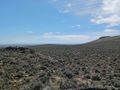
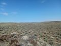
The hashpoint was about a mile and a half from the road, generally upward, and there was some variation along the way. The sagebrush got denser or thinner, the soil rockier or smoother, cacti were present sometimes and not other times. But basically, it's a very big sagebrush desert, and there's a whole lot of sameness to it. I found a hashpoint out there.
Then I walked back the way I came, got to the truck, and continued on to 2023-04-29 42 -117.
Photos
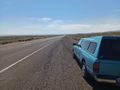
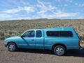
The truck at the side of Hwy 78.
The hashpoint is near the ridge at the horizon.
And there I was!
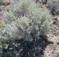
The hashpointsagebrush.
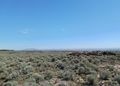
Looking to the northeast.
Looking south.
Looking northwest.
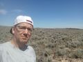
Me!


Achievements
Michael5000 earned the Graticule Unlocked Achievement
|
Michael5000 earned the Multihash Achievement
|
Michael5000 earned the Consecutive geohash achievement
|
Michael5000 achieved level 6 of the Minesweeper Geohash achievement
|