Difference between revisions of "2023-05-01 58 5"
From Geohashing
(An expedition message sent via Geohash Droid for Android.) |
(→Expedition) |
||
| (10 intermediate revisions by the same user not shown) | |||
| Line 12: | Line 12: | ||
| date=2023-05-01 | | date=2023-05-01 | ||
}}<!-- edit as necessary --> | }}<!-- edit as necessary --> | ||
| + | |||
| + | [[Image:20230501_58_5_Me.jpg|thumb|left]] | ||
== Location == | == Location == | ||
<!-- where you've surveyed the hash to be --> | <!-- where you've surveyed the hash to be --> | ||
| + | On a mountain pasture near Litla-Undheim, Time, Norway | ||
== Participants == | == Participants == | ||
<!-- who attended: If you link to your wiki user name in this section, your expedition will be picked up by the various statistics generated for geohashing. You may use three tildes ~ as a shortcut to automatically insert the user signature of the account you are editing with. | <!-- who attended: If you link to your wiki user name in this section, your expedition will be picked up by the various statistics generated for geohashing. You may use three tildes ~ as a shortcut to automatically insert the user signature of the account you are editing with. | ||
--> | --> | ||
| + | |||
| + | *[[User:Pica42|Pica42]] | ||
== Plans == | == Plans == | ||
| Line 24: | Line 29: | ||
== Expedition == | == Expedition == | ||
<!-- how it all turned out. your narrative goes here. --> | <!-- how it all turned out. your narrative goes here. --> | ||
| + | |||
| + | I had to wait until the afternoon before the rain stopped and the weather became suitable for a trip. On the way to the day's geohash, I found a small viper on the side of the road. Afterwards I went slightly the wrong way so I had to climb up a rock pile. The walk was only about 2 km round trip from where I parked. | ||
== Tracklog == | == Tracklog == | ||
| Line 33: | Line 40: | ||
--> | --> | ||
<gallery perrow="5"> | <gallery perrow="5"> | ||
| + | |||
| + | Image:2023-05-01_58_5_Pica42_1682947378262.jpg|Undheim | ||
| + | Image:20230501 58 5 East.jpg|thumb|View to the east. | ||
| + | Image:20230501 58 5 North west.jpg|thumb|View to the North West. | ||
| + | Image:20230501 58 5 North.jpg|thumb|View to the North. | ||
| + | Image:20230501 58 5 South West.jpg|thumb|View to the West. | ||
| + | Image:Orm.jpg|thumb|A hiking friend I met. | ||
</gallery> | </gallery> | ||
| Line 39: | Line 53: | ||
<!-- Add any achievement ribbons you earned below, or remove this section --> | <!-- Add any achievement ribbons you earned below, or remove this section --> | ||
| − | + | {{land geohash |name=[[User:Pica42|Pica42]] |date=2023-05-01 |latitude=58 |longitude=5 }} | |
| − | |||
| − | |||
| − | [[ | ||
| − | |||
| − | |||
| − | |||
| − | |||
| − | |||
| − | |||
| − | |||
| − | |||
| − | |||
| − | |||
| − | |||
[[Category:Expeditions]] | [[Category:Expeditions]] | ||
| − | |||
[[Category:Expeditions with photos]] | [[Category:Expeditions with photos]] | ||
| − | |||
| − | |||
| − | |||
| − | |||
| − | |||
[[Category:Coordinates reached]] | [[Category:Coordinates reached]] | ||
| + | {{location|NO|11}} | ||
| − | + | __NOTOC__ | |
| − | |||
| − | |||
| − | |||
| − | |||
| − | |||
| − | |||
| − | |||
| − | |||
| − | |||
| − | |||
| − | |||
| − | |||
| − | |||
| − | |||
| − | |||
| − | |||
Latest revision as of 16:28, 1 May 2023
| Mon 1 May 2023 in 58,5: 58.6960156, 5.7992520 geohashing.info google osm bing/os kml crox |

Location
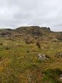
On a mountain pasture near Litla-Undheim, Time, Norway
Participants
Plans
Expedition
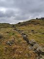
I had to wait until the afternoon before the rain stopped and the weather became suitable for a trip. On the way to the day's geohash, I found a small viper on the side of the road. Afterwards I went slightly the wrong way so I had to climb up a rock pile. The walk was only about 2 km round trip from where I parked.
Tracklog
Photos

Undheim
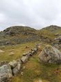
View to the east.
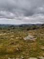
View to the North West.
View to the North.
View to the West.
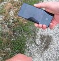
A hiking friend I met.


Achievements
Pica42 earned the Land geohash achievement
|