Difference between revisions of "2023-05-17 51 16"
(add OpenStreetMap achievement) |
(add missing minesweeper achievement) |
||
| (One intermediate revision by one other user not shown) | |||
| Line 35: | Line 35: | ||
{{bicycle geohash|date=2023-05-17|latitude=51|longitude=16|name=[[User:Piotrekoo|Piotrekoo]]|distance=44 km|bothways=true|image=2023-05-17 51 16 05 Hashbike.jpg}} | {{bicycle geohash|date=2023-05-17|latitude=51|longitude=16|name=[[User:Piotrekoo|Piotrekoo]]|distance=44 km|bothways=true|image=2023-05-17 51 16 05 Hashbike.jpg}} | ||
{{two to the N achievement|count=1|date=2023-05-17|latitude=51|longitude=16|name=[[User:Piotrekoo|Piotrekoo]]|reached=true}} | {{two to the N achievement|count=1|date=2023-05-17|latitude=51|longitude=16|name=[[User:Piotrekoo|Piotrekoo]]|reached=true}} | ||
| + | {{Minesweeper geohash|graticule=Wrocław East, Poland|ranknumber=1|w=true|name=[[User:Piotrekoo|Piotrekoo]]}} | ||
{{Minesweeper geohash|graticule=Wrocław West, Poland|ranknumber=1|e=true|name=[[User:Piotrekoo|Piotrekoo]]}} | {{Minesweeper geohash|graticule=Wrocław West, Poland|ranknumber=1|e=true|name=[[User:Piotrekoo|Piotrekoo]]}} | ||
{{OpenStreetMap achievement|latitude=51|longitude=16|date=2023-05-17|OSMlink=136230808|name=[[User:Piotrekoo|Piotrekoo]]}} | {{OpenStreetMap achievement|latitude=51|longitude=16|date=2023-05-17|OSMlink=136230808|name=[[User:Piotrekoo|Piotrekoo]]}} | ||
| Line 42: | Line 43: | ||
[[Category:Expeditions with photos]] | [[Category:Expeditions with photos]] | ||
{{location|PL|D|TR}} | {{location|PL|D|TR}} | ||
| − | {{user categories|user=Piotrekoo| | + | {{user categories|user=Piotrekoo|bike=44}} |
Latest revision as of 20:16, 27 June 2023
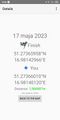
| Wed 17 May 2023 in 51,16: 51.2736596, 16.9814297 geohashing.info google osm bing/os kml crox |
Location
In a forest between Mienice and Golędzinów in the Trzebnickie Hills.
Participants
Expedition
After work, I went for a ride to reach the geohash. The route followed a bike path along the voivoideship road 359. In Wisznia Mała I turned left towards Piotrkowiczki and Mienice. There, I entered the hash-forest.
Finding the geohash position wasn't easy. The forest was dense, and even though GPS accuracy was okay, my position was constantly floating. I haven't seen any other person there. Calmness, beautiful tress, not to mention the smell. It was exceptional – pine trees, moist soil. It's not yet the time for blueberries, so I had a blackcurrant-flavoured energy gel.
After a short break, I hopped back on the bike and went towards Golędzinów. I found an unmapped path in the forest, so OpenStreetMap achievement, here I come. In Golędzinów I joined the voivoideship road 372 that took me back to Wrocław.
I prepared the route with the Tron achievement in mind, but I mixed up the turns and... well, maybe another time. When I get a gravel bike, I must return to that forest.
Photos
Proof
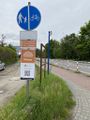
Beginning of the Lower Silesian Bicycle Land
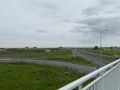
View from a bridge over the expressway S5
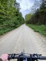
Gravel track
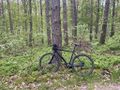
Hashbike at the geohash
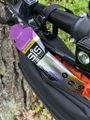
Treat time
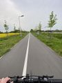
Motorway for bikes
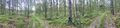
Panorama at the hashpoint


Tracklog
Achievements
Piotrekoo earned the Land geohash achievement
|
Piotrekoo earned the Bicycle geohash achievement
|

Piotrekoo achieved level 1 of the Minesweeper Geohash achievement
|
Piotrekoo achieved level 1 of the Minesweeper Geohash achievement
|
Piotrekoo earned the OpenStreetMap achievement
|
- Meetup on 2023-05-17
- Meetup in 51 16
- Expeditions with tracklogs
- Land geohash achievement
- Bicycle geohash achievement
- Two to the N achievement
- Minesweeper geohash achievement
- OpenStreetMap achievement
- Expeditions
- Coordinates reached
- Expeditions with photos
- Meetup in powiat trzebnicki
- Expeditions by Piotrekoo
- Piotrekoo's expeditions by bike